File:Mazowsze regiony Kondrackiego.png
Jump to navigation
Jump to search
Size of this preview: 624 × 599 pixels. Other resolutions: 250 × 240 pixels | 500 × 480 pixels | 800 × 768 pixels | 1,066 × 1,024 pixels | 1,439 × 1,382 pixels.
Original file (1,439 × 1,382 pixels, file size: 1.26 MB, MIME type: image/png)
Captions
Captions
Add a one-line explanation of what this file represents
Summary
[edit]
| Description |
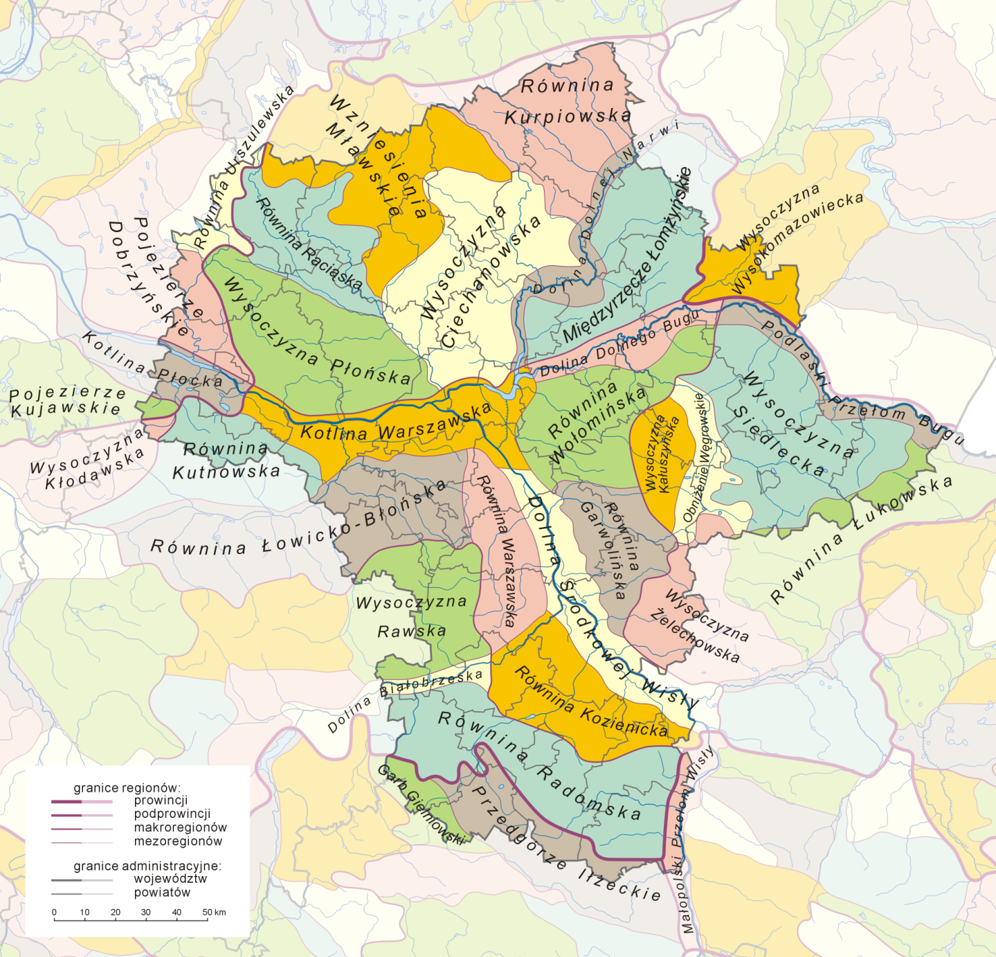
Polski: Mapa przedstawiająca mezoregiony fizycznogeograficzne województwa mazowieckiego |
| Source | Own work na podstawie: 1) granice mezoregionów: J. Kondracki, A. Richling Regiony Fizycznogeograficzne 1:1.500.000 [w:] Atlas Rzeczypospolitej Polskiej, Główny Geodeta Kraju, Warszawa 1994; 2) hydrografia: Atlas świata, Służba Topograficzna Wojska Polskiego, Warszawa 1962 z naniesionymi aktualizacjami z różnych źródeł; 3) podział administracyjny – Mapa Administracyjna Rzeczypospolitej Polskiej 1:500.000, Główny Geodeta Kraju, Warszawa 2003 z naniesionymi aktualizacjami |
| Author | Aotearoa |
Licensing
[edit]
I, the copyright holder of this work, hereby publish it under the following licenses:

|
Permission is granted to copy, distribute and/or modify this document under the terms of the GNU Free Documentation License, Version 1.2 or any later version published by the Free Software Foundation; with no Invariant Sections, no Front-Cover Texts, and no Back-Cover Texts. A copy of the license is included in the section entitled GNU Free Documentation License. |
| This file is licensed under the Creative Commons Attribution-Share Alike 3.0 Unported license. | ||
| ||
| This licensing tag was added to this file as part of the GFDL licensing update. |
You may select the license of your choice.
|
File history
Click on a date/time to view the file as it appeared at that time.
| Date/Time | Thumbnail | Dimensions | User | Comment | |
|---|---|---|---|---|---|
| current | 05:50, 12 May 2007 | | 1,439 × 1,382 (1.26 MB) | Aotearoa (talk | contribs) | |
| 10:34, 10 May 2007 |  | 1,439 × 1,385 (1.34 MB) | Aotearoa (talk | contribs) | ||
| 16:17, 8 May 2007 |  | 1,440 × 1,384 (1.29 MB) | Aotearoa (talk | contribs) | ||
| 05:00, 8 May 2007 |  | 1,439 × 1,384 (1.36 MB) | Aotearoa (talk | contribs) | ||
| 20:44, 6 May 2007 |  | 1,413 × 1,356 (689 KB) | Aotearoa (talk | contribs) | {{Information |Description=Regiony fizycznogeograficzne województwa mazowieckiego |Source=self-made |Date= |Author= Aotearoa }} |
You cannot overwrite this file.
File usage on Commons
The following page uses this file:
File usage on other wikis
The following other wikis use this file:
- Usage on pl.wikipedia.org
- Mapa
- Wikipedysta:Aotearoa/brudnopis
- Regionalizacja fizycznogeograficzna województwa mazowieckiego
- Wikipedia:Propozycje do Ilustracji na Medal/Mazowsze regiony Kondrackiego.png
- Wikiprojekt:Projekt Grafiki/Jak wykonać doskonałą mapę
- Dyskusja pliku:Mazowsze regiony Kondrackiego.png
- Dolina Dolnego Bugu
- Wikipedia:Ilustracje na Medal/rysunki i animacje
- Wikipedysta:Aotearoa/mapy
- Szablon:Ilustracja na medal/2011-09-12
- Szablon:Ilustracja na medal/2012-12-10
- Szablon:Ilustracja na medal/2013-11-07
- Wikipedysta:The Polish/Nieużywane szablony/Ilustracja na medal/1-500
- Wikipedysta:The Polish/Nieużywane szablony/Ilustracja na medal/501-1000
- Wikipedysta:The Polish/Nieużywane szablony/Ilustracja na medal/1001-1500
- Portal:Geografia/Zdjęcie/40
- Usage on pl.wikiquote.org