File:Mataram Baru 1830.png
Jump to navigation
Jump to search

Size of this preview: 604 × 599 pixels. Other resolutions: 242 × 240 pixels | 484 × 480 pixels | 774 × 768 pixels | 1,137 × 1,128 pixels.
Original file (1,137 × 1,128 pixels, file size: 54 KB, MIME type: image/png)
Captions
Captions
Add a one-line explanation of what this file represents
Summary[edit]
| Description |
Bahasa Indonesia: == Summary ==
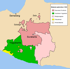
Peta Mataram Baru setelah Perang Diponegoro pada tahun 1830. Peta ini digambar oleh Meursault2004 alias Revo Arka Giri S. berdasarkan Robert Cribb, 2000, Historical Atlas of Indonesia halaman 114. LicensingKategori:Gambar peta |
| Date | 19 February 2006 (original upload date) |
| Source | Own work |
| Author | Meursault2004 at Indonesian Wikipedia |
Licensing[edit]
Meursault2004 at the Indonesian language Wikipedia, the copyright holder of this work, hereby publishes it under the following license:

|
Permission is granted to copy, distribute and/or modify this document under the terms of the GNU Free Documentation License, Version 1.2 or any later version published by the Free Software Foundation; with no Invariant Sections, no Front-Cover Texts, and no Back-Cover Texts. A copy of the license is included in the section entitled GNU Free Documentation License. |
| This file is licensed under the Creative Commons Attribution-Share Alike 3.0 Unported license. | ||
| Attribution: Meursault2004 at the Indonesian language Wikipedia | ||
| ||
| This licensing tag was added to this file as part of the GFDL licensing update. |
Original upload log[edit]
The original description page was here. All following user names refer to id.wikipedia.
| Date/Time | Dimensions | User | Comment |
|---|---|---|---|
| 2006-02-19 09:50 | 1137×1128× (55693 bytes) | Meursault2004 | Peta Mataram Baru setelah Perang Diponegoro pada tahun 1830. Peta ini digambar oleh ~~~ alias Revo Arka Giri S. berdasarkan Robert Cribb, 2000, Historical Atlas of Indonesia halaman 114. |
File history
Click on a date/time to view the file as it appeared at that time.
| Date/Time | Thumbnail | Dimensions | User | Comment | |
|---|---|---|---|---|---|
| current | 07:57, 19 May 2016 | | 1,137 × 1,128 (54 KB) | CommonSupporter (talk | contribs) | Transferred from id.wikipedia |
You cannot overwrite this file.
File usage on Commons
There are no pages that use this file.
File usage on other wikis
The following other wikis use this file:
- Usage on en.wikipedia.org
- Usage on es.wikipedia.org
- Usage on id.wikipedia.org
- Daerah Istimewa Yogyakarta
- Kesultanan Mataram
- Perang Diponegoro
- Sejarah Nusantara (1800–1942)
- Pengguna:Meursault2004/galeri foto
- Kesultanan Ngayogyakarta Hadiningrat
- Kadipatèn Mangkunagaran
- Kesunanan Surakarta Hadiningrat
- Kadipaten Pakualaman
- Vorstenlanden
- Portal:Surakarta
- Portal:Surakarta/Artikel pilihan/1
- Usage on jv.wikipedia.org
- Usage on ml.wikipedia.org
- Usage on ms.wikipedia.org
- Usage on mt.wikipedia.org
- Usage on www.wikidata.org