File:Massacre Canyon battlefield (1873), Nebraska. Pawnee reservation and relevant Indian territories.png
Jump to navigation
Jump to search
Size of this preview: 800 × 464 pixels. Other resolutions: 320 × 186 pixels | 640 × 371 pixels | 1,009 × 585 pixels.
Original file (1,009 × 585 pixels, file size: 282 KB, MIME type: image/png)
Captions
Captions
Add a one-line explanation of what this file represents
Summary
[edit],_Nebraska._Pawnee_reservation_and_relevant_Indian_territories.png&action=edit§ion=1)
| Description |
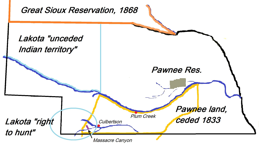
English: Map with Massacre Canyon battlefield (1873), Nebraska. Pawnee reservation and relevant Lakota territories. |
| Date | |
| Source | Own work |
| Author | Naawada2016 |
North America, U.S., Nebraska, Southern plains
Licensing
[edit],_Nebraska._Pawnee_reservation_and_relevant_Indian_territories.png&action=edit§ion=2)
I, the copyright holder of this work, hereby publish it under the following license:
This file is licensed under the Creative Commons Attribution-Share Alike 4.0 International license.
- You are free:
- to share – to copy, distribute and transmit the work
- to remix – to adapt the work
- Under the following conditions:
- attribution – You must give appropriate credit, provide a link to the license, and indicate if changes were made. You may do so in any reasonable manner, but not in any way that suggests the licensor endorses you or your use.
- share alike – If you remix, transform, or build upon the material, you must distribute your contributions under the same or compatible license as the original.
File history
Click on a date/time to view the file as it appeared at that time.
| Date/Time | Thumbnail | Dimensions | User | Comment | |
|---|---|---|---|---|---|
| current | 08:51, 21 July 2017 | | 1,009 × 585 (282 KB) | Naawada2016 (talk | contribs) | User created page with UploadWizard |
You cannot overwrite this file.
File usage on Commons
There are no pages that use this file.
File usage on other wikis
The following other wikis use this file:
- Usage on en.wikipedia.org
Metadata
,_Nebraska._Pawnee_reservation_and_relevant_Indian_territories.png&oldid=797006769)
Categories:
- Native American history of Nebraska
- Native American history of South Dakota
- Lakota people
- Massacres of Native Americans
- Pawnee maps
- Pawnee Reservation
- Massacre Canyon, Hitchcock County, Nebraska
- Sioux maps
- Battles in 1873
- Maps of the history of Nebraska
- Native American history of the 1830s
- Native American history of the 1860s
- Maps of Native American tribal territories