File:Maryland Campaign.png
Jump to navigation
Jump to search
Size of this preview: 531 × 600 pixels. Other resolutions: 212 × 240 pixels | 425 × 480 pixels | 680 × 768 pixels | 906 × 1,024 pixels | 1,601 × 1,809 pixels.
Original file (1,601 × 1,809 pixels, file size: 576 KB, MIME type: image/png)
Captions
Captions
Add a one-line explanation of what this file represents
Summary
[edit]
| Description |
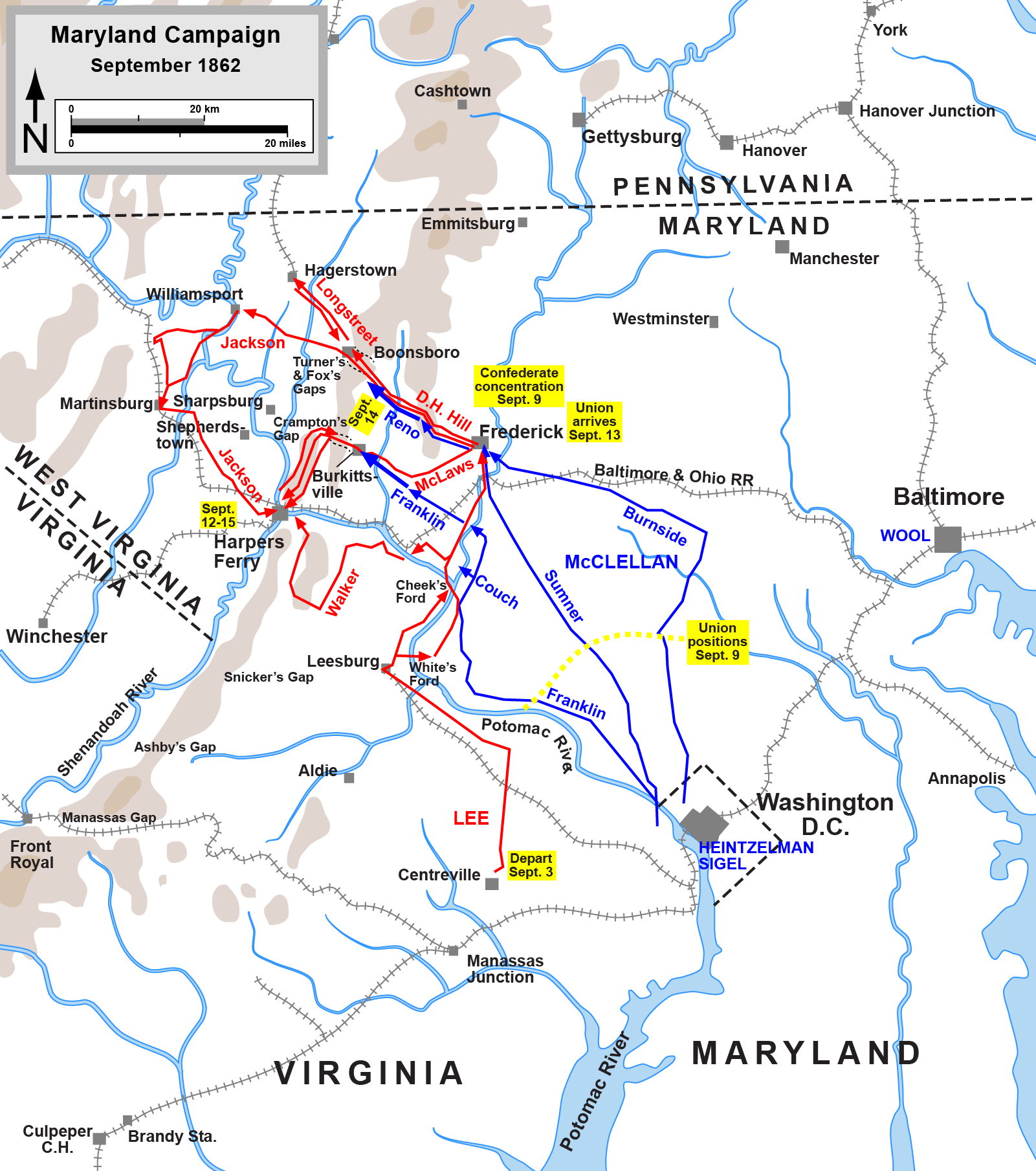
English: Map of the Maryland Campaign of the American Civil War, actions Sept. 3-15. Drawn by Hal Jespersen in Adobe Illustrator CS5. Graphic source file is available at http://www.posix.com/CWmaps/ |
| Date | (first version); 6 March 2011 (last version) |
| Source | http://www.posix.com/CWmaps/Maryland_Campaign.png |
| Author | Hal Jespersen at en.wikipedia |
| PNG development | This map was created with Adobe Illustrator. |
Licensing
[edit]
| This work has been released into the public domain by its author, Hal Jespersen. This applies worldwide. In some countries this may not be legally possible; if so: Hal Jespersen grants anyone the right to use this work for any purpose, without any conditions, unless such conditions are required by law.
|

|
File:Maryland Campaign a.svg is a vector version of this file. It should be used in place of this PNG file when not inferior.
File:Maryland Campaign.png → File:Maryland Campaign a.svg
For more information, see Help:SVG. |
 |
Original upload log
[edit]
(All user names refer to en.wikipedia)
- 2006-06-17 16:04 Hlj 1502×1700×8 (540349 bytes) Map of the [[Maryland Campaign]] of the [[American Civil War]], actions Sept. 3-15. Drawn by Hal Jespersen in Macromedia Freehand. Graphic source file is available at http://www.posix.com/CWmaps/
File history
Click on a date/time to view the file as it appeared at that time.
| Date/Time | Thumbnail | Dimensions | User | Comment | |
|---|---|---|---|---|---|
| current | 22:46, 29 March 2011 | | 1,601 × 1,809 (576 KB) | Hlj (talk | contribs) | Update to graphical format of rivers and roads. |
| 23:07, 6 March 2011 |  | 1,601 × 1,809 (450 KB) | Innotata (talk | contribs) | New version from enwiki, uploaded by original uploader. Upload summaries: "Fixed DC boundary. Adobe Illustrator source file at http://www.posix.com/CWmaps/"; "minor graphical changes to conform to style used by most ACW maps; added legend and scale." | |
| 02:09, 26 April 2007 |  | 1,502 × 1,700 (528 KB) | Qbek (talk | contribs) | {{Information |Description=Map of the en:Maryland Campaign of the en:American Civil War, actions Sept. 3-15. Drawn by Hal Jespersen in Macromedia Freehand. Graphic source file is available at http://www.posix.com/CWmaps/ |Source=Originally from |
You cannot overwrite this file.
File usage on Commons
The following page uses this file:
File usage on other wikis
The following other wikis use this file:
- Usage on azb.wikipedia.org
- Usage on cs.wikipedia.org
- Usage on da.wikipedia.org
- Usage on de.wikipedia.org
- Usage on es.wikipedia.org
- Usage on fa.wikipedia.org
- Usage on fr.wikipedia.org
- Usage on hu.wikipedia.org
- Usage on it.wikipedia.org
- Usage on ja.wikipedia.org
- Usage on ko.wikipedia.org
- Usage on la.wikipedia.org
- Usage on ms.wikipedia.org
- Usage on nl.wikipedia.org
- Usage on no.wikipedia.org
- Usage on pl.wikipedia.org
- Usage on pt.wikipedia.org
- Usage on ro.wikipedia.org
- Usage on sr.wikipedia.org
- Usage on vi.wikipedia.org
- Usage on zh.wikipedia.org