File:Mars moho topography (MOLA dataset).png
Jump to navigation
Jump to search

Size of this preview: 800 × 361 pixels. Other resolutions: 320 × 144 pixels | 640 × 289 pixels | 1,024 × 462 pixels | 1,280 × 578 pixels | 2,880 × 1,300 pixels.
Original file (2,880 × 1,300 pixels, file size: 1.74 MB, MIME type: image/png)
Captions
Captions
Add a one-line explanation of what this file represents
Summary[edit]
.png&action=edit§ion=1)
| Description |
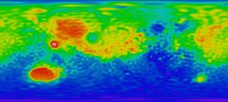
English: Mars Mantle (MOHO) Topography Map. Red means high area and blue means low area, which reveals that the crust in red area is relatively thin and the crust in blue area thick, taking surface topography into consideration.
|
| Date | |
| Source |
http://svs.gsfc.nasa.gov/stories/MOLA/ http://svs.gsfc.nasa.gov/vis/a000000/a001000/a001092/high_res_flat_moho.tif |
| Author |
NASA - Goddard Space Flight Center Scientific Visualization Studio Television Production NASA-TV/GSFC The MOLA Instrument and Science Team |
| Other versions |
.png) .png) |
Licensing[edit]
.png&action=edit§ion=2)
| This file is in the public domain in the United States because it was solely created by NASA. NASA copyright policy states that "NASA material is not protected by copyright unless noted". (See Template:PD-USGov, NASA copyright policy page or JPL Image Use Policy.) | ||
 |
Warnings:
|
File history
Click on a date/time to view the file as it appeared at that time.
| Date/Time | Thumbnail | Dimensions | User | Comment | |
|---|---|---|---|---|---|
| current | 05:20, 4 February 2010 | | 2,880 × 1,300 (1.74 MB) | Areong (talk | contribs) | {{Information |Description={{en|1=Mars Mantle (MOHO) Topography Map. Red means high area and blue means low area, which reveals that the crust in red area is relatively thin and the crust in blue area thick, taking surface topography into concern. It is |
You cannot overwrite this file.
File usage on Commons
The following 3 pages use this file:
File usage on other wikis
The following other wikis use this file:
- Usage on fr.wikipedia.org
- Usage on fr.wikibooks.org
- Usage on zh.wikipedia.org
.png&oldid=481676646)