File:Mappa ferr Palermo-Agrigento-Porto Empedocle.png
Jump to navigation
Jump to search

Size of this preview: 314 × 599 pixels. Other resolutions: 125 × 240 pixels | 251 × 480 pixels | 402 × 768 pixels | 536 × 1,024 pixels | 1,300 × 2,482 pixels.
Original file (1,300 × 2,482 pixels, file size: 364 KB, MIME type: image/png)
Captions
Captions
Add a one-line explanation of what this file represents
Summary
[edit]
| Description |
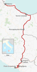
Deutsch: Karte der Palermo–Agrigento/Porto Empedocle
English: Outline map railway line Palermo–Agrigento/Porto Empedocle
Italiano: Mappa della ferrovia Palermo–Agrigento/Porto Empedocle |
| Source |
Own work, Hintergrund: OpenStreetMap LicensingI, the copyright holder of this work, hereby publish it under the following license: This file is licensed under the Creative Commons Attribution-Share Alike 4.0 International license.
|
| Author | Patrick1977 |
File history
Click on a date/time to view the file as it appeared at that time.
| Date/Time | Thumbnail | Dimensions | User | Comment | |
|---|---|---|---|---|---|
| current | 22:49, 27 December 2017 | | 1,300 × 2,482 (364 KB) | Patrick1977 (talk | contribs) | Größere Auflösung |
| 20:41, 26 December 2017 |  | 500 × 950 (91 KB) | Patrick1977 (talk | contribs) | Variante di Lercara | |
| 23:30, 3 January 2017 |  | 1,300 × 1,984 (273 KB) | Patrick1977 (talk | contribs) | Fehlerkorrektur in Karte | |
| 22:55, 3 January 2017 |  | 1,300 × 1,985 (285 KB) | Patrick1977 (talk | contribs) | Neutrassierung Roccapalumba–Castronovo 1/2017 Nuova tratta Roccapalumba - Castronovo | |
| 19:54, 15 July 2016 |  | 1,300 × 1,979 (292 KB) | Patrick1977 (talk | contribs) | Genauere Situation in Aragona | |
| 13:37, 5 June 2011 |  | 1,024 × 988 (141 KB) | Arbalete (talk | contribs) | {{Information |Description ={{it|1=Mappa della ferrovia Palermo-Agrigento-Porto Empedocle}} |Source ={{own}} |Author =Friedrichstrasse |Date =2011-06 |Permission = |other_versions = }} [[Category |
You cannot overwrite this file.
File usage on Commons
The following 15 pages use this file:
- User:Chumwa/OgreBot/Potential transport maps/2016 July 11-20
- User:Chumwa/OgreBot/Potential transport maps/2017 December 21-31
- User:Chumwa/OgreBot/Potential transport maps/2017 January 1-10
- User:Chumwa/OgreBot/Public transport information/2016 July 11-20
- User:Chumwa/OgreBot/Public transport information/2017 December 21-31
- User:Chumwa/OgreBot/Public transport information/2017 January 1-10
- User:Chumwa/OgreBot/Transport Maps/2016 July 11-20
- User:Chumwa/OgreBot/Transport Maps/2017 December 21-31
- User:Chumwa/OgreBot/Transport Maps/2017 January 1-10
- User:Chumwa/OgreBot/Travel and communication maps/2016 July 11-20
- User:Chumwa/OgreBot/Travel and communication maps/2017 December 21-31
- User:Chumwa/OgreBot/Travel and communication maps/2017 January 1-10
- User:Patrick1977
- Category:Agrigento Bassa–Porto Empedocle railway
- Category:Agrigento–Palermo railway
File usage on other wikis
The following other wikis use this file:
- Usage on de.wikipedia.org
- Usage on fr.wikipedia.org
- Usage on hu.wikipedia.org
- Usage on it.wikipedia.org
- Usage on it.wikivoyage.org
- Usage on lmo.wikipedia.org
- Usage on nl.wikivoyage.org
- Usage on www.wikidata.org