File:Mapa dos caminhos de ferro em Portugal 1895 - Rede do Minho.jpg
Jump to navigation
Jump to search
Size of this preview: 438 × 599 pixels. Other resolutions: 175 × 240 pixels | 512 × 700 pixels.
Original file (512 × 700 pixels, file size: 373 KB, MIME type: image/jpeg)
Captions
Captions
Add a one-line explanation of what this file represents
Summary[edit]
| Description |
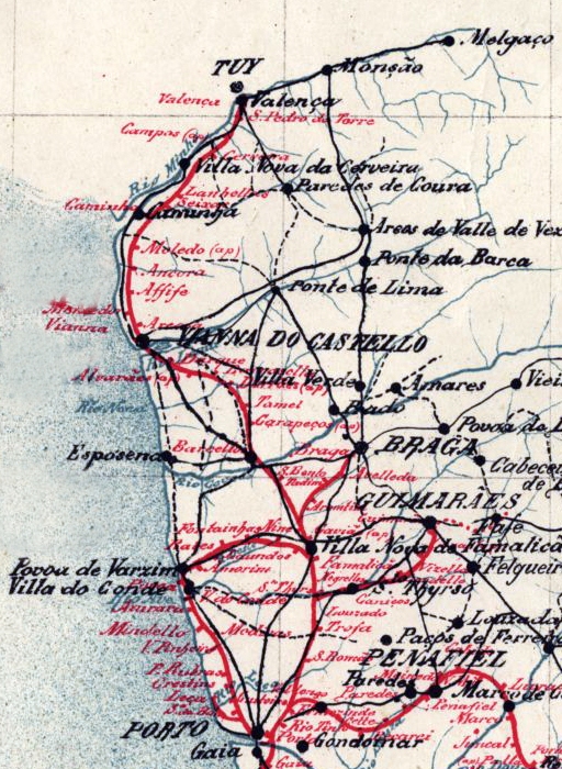
English: Map of the railway network at the Minho and Douro Litoral regions, in northen Portugal, in 1895. The main axis was the Linha do Minho (Minho Railway), in iberian gauge, connecting the city of Porto to the border town of Valença, with a spur to Braga. There was also a network of narrow gauge lines, connecting the city of Porto to Póvoa de Varzim, Guimarães and Famalicão. Português: Mapa da rede ferroviária nas antigas regiões portuguesas do Minho e Douro Litoral, em 1895. A espinha dorsal deste sistema era a Linha do Minho, de bitola ibérica, que ligava o Porto a Valença, com um ramal para Braga. Existia também uma rede ferroviária secundária, de bitola métrica, unindo o Porto a Guimarães, Póvoa de Varzim e Famalicão. |
| Date | (UTC) |
| Source |
This file was derived from: Mapa dos caminhos de ferro em Portugal 1895.jpg:  |
| Author |
|
| This is a retouched picture, which means that it has been digitally altered from its original version. Modifications: Isolated the Minho and Douro Litoral regions. The original can be viewed here: Mapa dos caminhos de ferro em Portugal 1895.jpg:
|
Licensing[edit]
|
This work is in the public domain in its country of origin and other countries and areas where the copyright term is the author's life plus 70 years or fewer. This work is in the public domain in the United States because it was published (or registered with the U.S. Copyright Office) before January 1, 1929. | |
| This file has been identified as being free of known restrictions under copyright law, including all related and neighboring rights. | |
Original upload log[edit]
This image is a derivative work of the following images:
- File:Mapa dos caminhos de ferro em Portugal 1895.jpg licensed with PD-old-70-expired
- 2015-08-30T17:29:23Z Polyethylen 2382x3892 (8926900 Bytes) User created page with UploadWizard
Uploaded with derivativeFX
File history
Click on a date/time to view the file as it appeared at that time.
| Date/Time | Thumbnail | Dimensions | User | Comment | |
|---|---|---|---|---|---|
| current | 13:33, 12 September 2020 | | 512 × 700 (373 KB) | Ajpvalente (talk | contribs) | == {{int:filedesc}} == {{Information |Description={{en|1=Map of the railway network at the Minho and Douro Litoral regions, in northen Portugal, in 1895. The main axis was the Linha do Minho (Minho Railway), in iberian gauge, connecting the city of Porto to the border town of Valença, with a spur to Braga. There was also a network of narrow gauge lines, connecting the city of Porto to Póvoa de Varzim, Guimarães and Famalicão.}}{{pt|1=Mapa da rede ferroviária nas antigas regiões portuguesas do... |
You cannot overwrite this file.
File usage on Commons
The following 3 pages use this file:
File usage on other wikis
The following other wikis use this file: