File:Mapa del Metro de Barcelona.jpg
Jump to navigation
Jump to search
Size of this preview: 800 × 534 pixels. Other resolutions: 320 × 213 pixels | 640 × 427 pixels | 1,024 × 683 pixels | 1,346 × 898 pixels.
Original file (1,346 × 898 pixels, file size: 500 KB, MIME type: image/jpeg)
Captions
Captions
Add a one-line explanation of what this file represents
Summary[edit]
| Description |
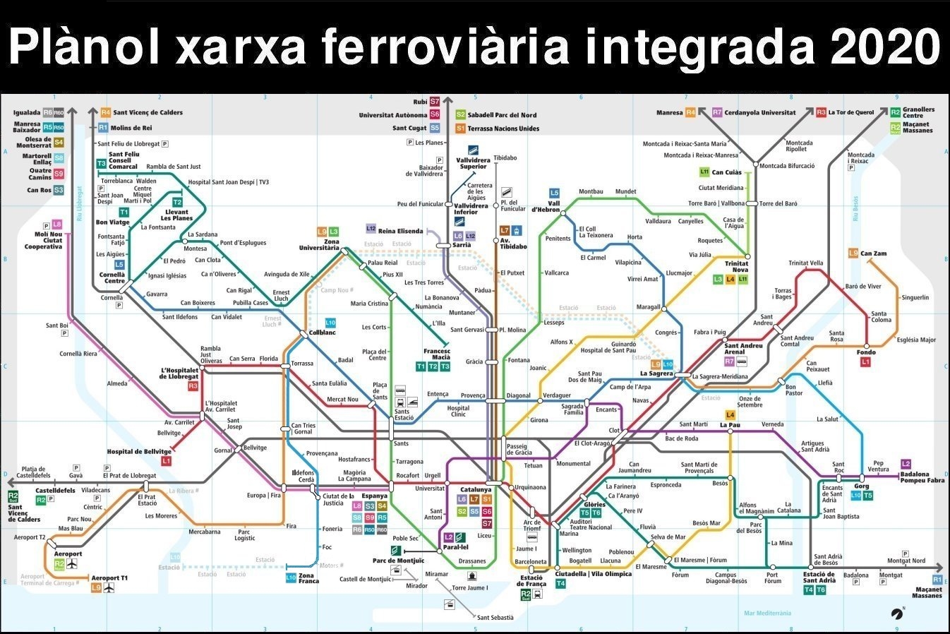
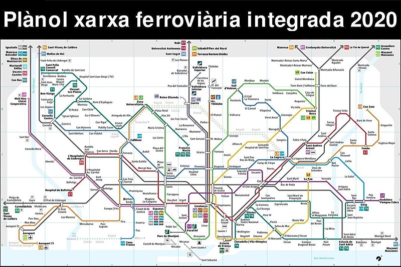
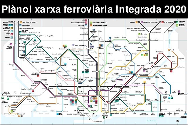
Català: Mapa del Metro de Barcelona i la resta de serveis ferroviaris de la primera corona de la Xarxa Ferroviària Integrada. |
| Date | |
| Source | Own work |
| Author | Josep Maria 15. |


Licensing[edit]
I, the copyright holder of this work, hereby publish it under the following license:
This file is licensed under the Creative Commons Attribution-Share Alike 3.0 Unported license.
- You are free:
- to share – to copy, distribute and transmit the work
- to remix – to adapt the work
- Under the following conditions:
- attribution – You must give appropriate credit, provide a link to the license, and indicate if changes were made. You may do so in any reasonable manner, but not in any way that suggests the licensor endorses you or your use.
- share alike – If you remix, transform, or build upon the material, you must distribute your contributions under the same or compatible license as the original.
File history
Click on a date/time to view the file as it appeared at that time.
| Date/Time | Thumbnail | Dimensions | User | Comment | |
|---|---|---|---|---|---|
| current | 02:00, 31 January 2020 | | 1,346 × 898 (500 KB) | Josep Maria Roca Peña (talk | contribs) | İnauguració de les dues noves estacions de ľL10 Sud: “Ciutat de la Justícia” (23 de novembre del 2019) i “Zona Franca” (1 de febrer del 2020). |
| 20:00, 2 March 2019 |  | 1,346 × 898 (250 KB) | Josep Maria Roca Peña (talk | contribs) | İnauguració de ľestació “Provençana” (L10 Sud). | |
| 20:48, 7 September 2018 |  | 1,346 × 898 (251 KB) | Josep Maria Roca Peña (talk | contribs) | Mapa del 2018 amb la inauguració de la línia 10 Sud que s’obre el dia 8 de setembre. | |
| 01:30, 7 December 2017 |  | 1,346 × 898 (572 KB) | Josep Maria Roca Peña (talk | contribs) | Petits canvis als logos dels tranvies. | |
| 01:02, 7 December 2017 |  | 1,346 × 898 (572 KB) | Josep Maria Roca Peña (talk | contribs) | Petits canvis. | |
| 00:30, 7 December 2017 |  | 1,346 × 898 (569 KB) | Josep Maria Roca Peña (talk | contribs) | Millor qualitat / Mejor calidad / Better quality | |
| 00:00, 15 September 2017 |  | 1,346 × 898 (508 KB) | Josep Maria Roca Peña (talk | contribs) | Un petit canvi ďordre. | |
| 20:32, 13 September 2017 |  | 1,346 × 898 (251 KB) | Josep Maria Roca Peña (talk | contribs) | Error a la destinació de la S7, sobrava “Sant Cugat - ”. | |
| 23:42, 31 July 2017 |  | 1,346 × 898 (252 KB) | Josep Maria Roca Peña (talk | contribs) | Mapa del 2017 amb les noves actualitzacions dels FGC. | |
| 10:55, 27 September 2016 |  | 2,725 × 2,020 (1.66 MB) | Josep Maria Roca Peña (talk | contribs) | Petits canvis. |
You cannot overwrite this file.
File usage on Commons
The following 40 pages use this file:
- User:Chumwa/OgreBot/Potential transport maps/2016 February 10-19
- User:Chumwa/OgreBot/Potential transport maps/2016 January 21-31
- User:Chumwa/OgreBot/Potential transport maps/2016 September 11-20
- User:Chumwa/OgreBot/Potential transport maps/2016 September 21-30
- User:Chumwa/OgreBot/Potential transport maps/2017 December 1-10
- User:Chumwa/OgreBot/Potential transport maps/2017 July 21-31
- User:Chumwa/OgreBot/Potential transport maps/2017 September 11-20
- User:Chumwa/OgreBot/Potential transport maps/2018 September 1-10
- User:Chumwa/OgreBot/Potential transport maps/2019 March 1-10
- User:Chumwa/OgreBot/Potential transport maps/2020 January 21-31
- User:Chumwa/OgreBot/Public transport information/2016 February 10-19
- User:Chumwa/OgreBot/Public transport information/2016 January 21-31
- User:Chumwa/OgreBot/Public transport information/2016 September 11-20
- User:Chumwa/OgreBot/Public transport information/2016 September 21-30
- User:Chumwa/OgreBot/Public transport information/2017 December 1-10
- User:Chumwa/OgreBot/Public transport information/2017 July 21-31
- User:Chumwa/OgreBot/Public transport information/2017 September 11-20
- User:Chumwa/OgreBot/Public transport information/2018 September 1-10
- User:Chumwa/OgreBot/Public transport information/2019 March 1-10
- User:Chumwa/OgreBot/Public transport information/2020 January 21-31
- User:Chumwa/OgreBot/Transport Maps/2016 February 10-19
- User:Chumwa/OgreBot/Transport Maps/2016 January 21-31
- User:Chumwa/OgreBot/Transport Maps/2016 September 11-20
- User:Chumwa/OgreBot/Transport Maps/2016 September 21-30
- User:Chumwa/OgreBot/Transport Maps/2017 December 1-10
- User:Chumwa/OgreBot/Transport Maps/2017 July 21-31
- User:Chumwa/OgreBot/Transport Maps/2017 September 11-20
- User:Chumwa/OgreBot/Transport Maps/2018 September 1-10
- User:Chumwa/OgreBot/Transport Maps/2019 March 1-10
- User:Chumwa/OgreBot/Transport Maps/2020 January 21-31
- User:Chumwa/OgreBot/Travel and communication maps/2016 February 10-19
- User:Chumwa/OgreBot/Travel and communication maps/2016 January 21-31
- User:Chumwa/OgreBot/Travel and communication maps/2016 September 11-20
- User:Chumwa/OgreBot/Travel and communication maps/2016 September 21-30
- User:Chumwa/OgreBot/Travel and communication maps/2017 December 1-10
- User:Chumwa/OgreBot/Travel and communication maps/2017 July 21-31
- User:Chumwa/OgreBot/Travel and communication maps/2017 September 11-20
- User:Chumwa/OgreBot/Travel and communication maps/2018 September 1-10
- User:Chumwa/OgreBot/Travel and communication maps/2019 March 1-10
- File:Red ferroviaria integrada.png (file redirect)
File usage on other wikis
The following other wikis use this file:
- Usage on ca.wikipedia.org
- Usage on eo.wikipedia.org
- Usage on hu.wikipedia.org
- Usage on it.wikivoyage.org
- Usage on nl.wikipedia.org