File:Mapa de la campiña de Guadalajara y Alcalá (Manuel de Navacerrada 13-04-1770) proyecto de canal de regadío.png
Jump to navigation
Jump to search

Size of this preview: 800 × 326 pixels. Other resolutions: 320 × 130 pixels | 640 × 260 pixels | 1,024 × 417 pixels | 1,280 × 521 pixels | 2,560 × 1,042 pixels | 5,303 × 2,158 pixels.
Original file (5,303 × 2,158 pixels, file size: 18.98 MB, MIME type: image/png)
Captions
Captions
Add a one-line explanation of what this file represents
Summary[edit]
_proyecto_de_canal_de_regad%C3%ADo.png&action=edit§ion=1)
| Description |
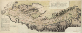
Español: Mapa de la campiña de Guadalajara y Alcalá como proyecto de canal de regadío desde el río Henares. El promotor inicial del proyecto fue Pedro Pablo Abarca de Bolea y Ximenez de Urrea (Conde de Aranda). Este canal se iniciaba en Humanes, en la confluencia de los ríos Sorbe y Henares, llegando hasta Paracuellos del Jarama para desembocar en el río Jarama. Posteriormente se acortó hasta el arroyo Torote, para al final alcanzar sólo hasta Meco, convirtiéndose en el actual Canal del Henares. Mapa de 72,8 x 177,5 cm, dibujado por Manuel de Navacerrada a escala ca. 1:36.000, y firmado el 13 de abril de 1770. Depositado en el Archivo General de Simancas: signatura: MPD, 22, 050 — nº de registro: AGS06258 |
| Date | |
| Source | Manuel de Navacerrada. Mapa de la Campiña de Guadalaxara y Alcalá que comprende desde la Junta de los Ríos Sorbe y Enares hasta la del Enares con Jarama demostrando el jiro de la línea de nivelación para una azequia de regadío executado con orden del Exmo. Sr. Conde de Aranda. Madrid, 13/04/1770. |
| Author | Manuel de Navacerrada |
| Permission (Reusing this file) |
PD-old-70-expired |
| Camera location | | View this and other nearby images on: OpenStreetMap |
|---|
_proyecto_de_canal_de_regad%C3%ADo.png¶ms=040.480118_N_-003.348301_E_globe:Earth_type:camera__&language=en)
Licensing[edit]
_proyecto_de_canal_de_regad%C3%ADo.png&action=edit§ion=2)
|
This work is in the public domain in its country of origin and other countries and areas where the copyright term is the author's life plus 70 years or fewer. This work is in the public domain in the United States because it was published (or registered with the U.S. Copyright Office) before January 1, 1929. | |
| This file has been identified as being free of known restrictions under copyright law, including all related and neighboring rights. | |
File history
Click on a date/time to view the file as it appeared at that time.
| Date/Time | Thumbnail | Dimensions | User | Comment | |
|---|---|---|---|---|---|
| current | 18:56, 30 December 2022 | 5,303 × 2,158 (18.98 MB) | Raimundo Pastor (talk | contribs) | Uploaded a work by Manuel de Navacerrada from [http://www.mcu.es/ccbae/es/consulta/registro.do?control=BAB20100059982 Manuel de Navacerrada. Mapa de la Campiña de Guadalaxara y Alcalá que comprende desde la Junta de los Ríos Sorbe y Enares hasta la del Enares con Jarama demostrando el jiro de la línea de nivelación para una azequia de regadío executado con orden del Exmo. Sr. Conde de Aranda. Madrid, 13/04/1770. with UploadWizard |
You cannot overwrite this file.
File usage on Commons
The following 2 pages use this file:
File usage on other wikis
The following other wikis use this file:
- Usage on es.wikipedia.org
Metadata
_proyecto_de_canal_de_regadío.png&oldid=819786068)
Categories:
- Manuel de Navacerrada
- 1770 maps of Spain
- 1770 in art
- 1770 documents
- Topographic maps of Spain
- Maps of Castilla la Nueva
- Spanish-language maps
- PNG maps of Alcalá de Henares
- Campiña de Guadalajara
- Henares river in the province of Guadalajara
- History of the province of Guadalajara
- Comarca de Alcalá
- Henares River in the Community of Madrid
- Coppices in Spain
- Documents in the Archivo General de Simancas
- Documents in Spanish
- Spanish-language manuscripts
- PNG paintings
- Canal del Henares
- Conde de Aranda
- 1770 in Alcalá de Henares