File:Mapa de la Argentina - 1869.jpg
Jump to navigation
Jump to search

Size of this preview: 472 × 599 pixels. Other resolutions: 189 × 240 pixels | 378 × 480 pixels | 756 × 960 pixels.
Original file (756 × 960 pixels, file size: 210 KB, MIME type: image/jpeg)
Captions
Captions
Add a one-line explanation of what this file represents
Summary
[edit]
| Description |
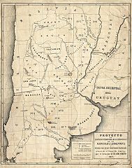
Español: Mapa de la República Argentina: Limitación territorial de las provincias y demarcación de los territorrios nacionales presentado al Congreso por el senador Nicasio Oroño. Año 1869.
Mapoteca II - 8. |
| Date | circa 1869 |
| Source | Archivo General de la Nación Argentina - Mapoteca II -8. |
| Author | Nicasio Oroño (1825-1904) |
Licensing
[edit]
|
This work is in the public domain in its country of origin and other countries and areas where the copyright term is the author's life plus 100 years or fewer. This work is in the public domain in the United States because it was published (or registered with the U.S. Copyright Office) before January 1, 1929. | |
| This file has been identified as being free of known restrictions under copyright law, including all related and neighboring rights. | |
File history
Click on a date/time to view the file as it appeared at that time.
| Date/Time | Thumbnail | Dimensions | User | Comment | |
|---|---|---|---|---|---|
| current | 16:45, 4 October 2015 | | 756 × 960 (210 KB) | Cacen Gymraeg (talk | contribs) | User created page with UploadWizard |
You cannot overwrite this file.
File usage on Commons
There are no pages that use this file.