File:Mapa Vicariato Apostolico de Tierradentro.svg

Original file (SVG file, nominally 549 × 538 pixels, file size: 226 KB)
Captions
Captions
| DescriptionMapa Vicariato Apostolico de Tierradentro.svg |
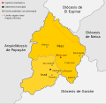
Español: Mapa del Vicariato Apostólico de Tierradentro. Colombia.
El Vicariato de Tierradentro (Cauca), está situado en el departamento del Cauca, con los límites del Departamento de Huila, sobre el flanco derecho de la Cordillera Central. Tiene una extensión de 2.085 kilómetros cuadrados. Está conformado por el municipio de Inzá, con una extensión de 801 Km² y el municipio de Páez (cuya cabecera municipal es Belalcázar) con una extensión de 1.284 Km². NOTA: El mapa del vicariato de Tierradentro esta basado en los mapas municipales de Páez e Inzá, pues los mapas departamentales oficiales como los del Instituto Geográfico Agustín Codazzi -IGAC-, tienen serios errores limítrofes, tanto en los limites municipales como departamentales. |
| Date | |
| Source | Own work |
| Author | SajoR |
| Permission (Reusing this file) |
Trabajo propio, reconocimiento requerido, mantener licencia:(Creative Commons CC-BY-SA-2.5). Citar a Wikipedia ó a Wikimedia como fuente si la imagen es utilizada en otros medios que no sean de los proyectos de la familia Wikipedia. I, SajoR, the copyright holder of this work, hereby publishes it under the following license: This file is licensed under the Creative Commons Attribution-Share Alike 2.5 Generic license. Attribution: I, SajoR
|
File history
Click on a date/time to view the file as it appeared at that time.
| Date/Time | Thumbnail | Dimensions | User | Comment | |
|---|---|---|---|---|---|
| current | 23:20, 9 October 2012 |  | 549 × 538 (226 KB) | SajoR (talk | contribs) | agrego centros poblados con parroquia |
| 01:58, 17 May 2012 |  | 549 × 538 (205 KB) | SajoR (talk | contribs) | Ajustes varios | |
| 05:13, 30 December 2011 |  | 549 × 538 (217 KB) | SajoR (talk | contribs) | {{Information |Description ={{es|1=Mapa del Vicariato Apostólico de Tierradentro. Colombia.}} |Source ={{own}} |Author =SajoR |Date =2011-12-30 |Permission ='''Trabajo propio, reconocimiento requerido, mant |
You cannot overwrite this file.
File usage on Commons
The following page uses this file:
File usage on other wikis
The following other wikis use this file:
- Usage on de.wikipedia.org
- Usage on es.wikipedia.org
- Usage on fr.wikipedia.org
- Usage on it.wikipedia.org
- Usage on nl.wikipedia.org
- Usage on pl.wikipedia.org
- Usage on ru.wikipedia.org
Metadata
This file contains additional information such as Exif metadata which may have been added by the digital camera, scanner, or software program used to create or digitize it. If the file has been modified from its original state, some details such as the timestamp may not fully reflect those of the original file. The timestamp is only as accurate as the clock in the camera, and it may be completely wrong.
| Width | 548.9765 |
|---|---|
| Height | 537.60706 |