File:Mapa MPK Włocławek.png
Jump to navigation
Jump to search

Size of this preview: 509 × 600 pixels. Other resolutions: 204 × 240 pixels | 407 × 480 pixels | 652 × 768 pixels | 869 × 1,024 pixels | 1,739 × 2,048 pixels | 8,080 × 9,517 pixels.
Original file (8,080 × 9,517 pixels, file size: 5.71 MB, MIME type: image/png)
Captions
Captions
Add a one-line explanation of what this file represents
Summary[edit]
| Description |
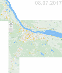
Polski: Plan miasta Włocławek z naniesionym układem tras komunikacyjnych MPK Włocławek, z wyjątkiem linii okresowych. Mapa aktualna na 08.07.2017. |
| Date | |
| Source | Own work |
| Author | Norbert Marszałek |
Licensing[edit]
I, the copyright holder of this work, hereby publish it under the following license:
This file is licensed under the Creative Commons Attribution-Share Alike 4.0 International license.
- You are free:
- to share – to copy, distribute and transmit the work
- to remix – to adapt the work
- Under the following conditions:
- attribution – You must give appropriate credit, provide a link to the license, and indicate if changes were made. You may do so in any reasonable manner, but not in any way that suggests the licensor endorses you or your use.
- share alike – If you remix, transform, or build upon the material, you must distribute your contributions under the same or compatible license as the original.
File history
Click on a date/time to view the file as it appeared at that time.
| Date/Time | Thumbnail | Dimensions | User | Comment | |
|---|---|---|---|---|---|
| current | 23:25, 7 July 2017 | | 8,080 × 9,517 (5.71 MB) | Nm91 (talk | contribs) | Poprawka błędu. |
| 23:10, 7 July 2017 |  | 8,080 × 9,517 (5.61 MB) | Nm91 (talk | contribs) | Aktualizacja związana ze zmianą tras (lub uruchomieniem) linii nr 2, 6, 14, 15. | |
| 22:50, 4 April 2017 |  | 8,080 × 9,517 (5.68 MB) | Nm91 (talk | contribs) | Aktualizacja związana ze zmianą tras linii nr 10, 20 i 23. | |
| 22:55, 9 March 2017 |  | 8,080 × 9,517 (5.68 MB) | Nm91 (talk | contribs) | Aktualizacja związana z likwidacją linii nr 5, zmianą tras linii nr 11, 13 i 17 oraz uzupełnieniem obrysów budynków. | |
| 17:40, 31 August 2016 |  | 8,080 × 9,517 (5.69 MB) | Nm91 (talk | contribs) | Aktualizacja związana ze zmianą trasy linii nr 3, 12 i 15. | |
| 23:50, 18 June 2016 |  | 8,080 × 9,517 (5.63 MB) | Nm91 (talk | contribs) | Uzupełnienie mapy o linie W1 i W2 oraz nowy fragment linii P. | |
| 23:50, 30 April 2016 |  | 8,080 × 9,517 (5.61 MB) | Nm91 (talk | contribs) | Uzupełnienie mapy o linie nr 3A, 3B, 16A, 16B i P. | |
| 19:50, 2 September 2015 |  | 8,080 × 9,517 (4.96 MB) | Nm91 (talk | contribs) | Aktualizacja związana ze zmianą trasy linii nr 2, 3, 4, 10, 12, 15, 19, 20 i powiększeniem obszaru mapy o końcowe fragmenty linii podmiejskich. | |
| 19:37, 5 July 2015 |  | 7,133 × 7,477 (4.55 MB) | Nm91 (talk | contribs) | Aktualizacja związana ze zmianą trasy linii nr 5. | |
| 19:57, 8 April 2015 |  | 7,133 × 7,477 (4.38 MB) | Nm91 (talk | contribs) | Aktualizacja związana z przywróceniem linii nr 5 i zlikwidowaniem linii T1 i T2. |
You cannot overwrite this file.
File usage on Commons
The following 32 pages use this file:
- User:Chumwa/OgreBot/Potential transport maps/2016 April 21-30
- User:Chumwa/OgreBot/Potential transport maps/2016 August 21-31
- User:Chumwa/OgreBot/Potential transport maps/2016 June 11-20
- User:Chumwa/OgreBot/Potential transport maps/2017 April 1-10
- User:Chumwa/OgreBot/Potential transport maps/2017 July 1-10
- User:Chumwa/OgreBot/Potential transport maps/2017 March 1-10
- User:Chumwa/OgreBot/Public transport information/2014 October 21-31
- User:Chumwa/OgreBot/Public transport information/2015 April 1-10
- User:Chumwa/OgreBot/Public transport information/2015 July 1-10
- User:Chumwa/OgreBot/Public transport information/2015 September 1-10
- User:Chumwa/OgreBot/Public transport information/2016 April 21-30
- User:Chumwa/OgreBot/Public transport information/2016 August 21-31
- User:Chumwa/OgreBot/Public transport information/2016 June 11-20
- User:Chumwa/OgreBot/Public transport information/2017 July 1-10
- User:Chumwa/OgreBot/Public transport information/2017 March 1-10
- User:Chumwa/OgreBot/Transport Maps/2014 October 21-31
- User:Chumwa/OgreBot/Transport Maps/2015 April 1-10
- User:Chumwa/OgreBot/Transport Maps/2015 July 1-10
- User:Chumwa/OgreBot/Transport Maps/2015 September 1-10
- User:Chumwa/OgreBot/Transport Maps/2016 April 21-30
- User:Chumwa/OgreBot/Transport Maps/2016 August 21-31
- User:Chumwa/OgreBot/Transport Maps/2016 June 11-20
- User:Chumwa/OgreBot/Transport Maps/2017 April 1-10
- User:Chumwa/OgreBot/Transport Maps/2017 July 1-10
- User:Chumwa/OgreBot/Transport Maps/2017 March 1-10
- User:Chumwa/OgreBot/Travel and communication maps/2016 April 21-30
- User:Chumwa/OgreBot/Travel and communication maps/2016 August 21-31
- User:Chumwa/OgreBot/Travel and communication maps/2016 June 11-20
- User:Chumwa/OgreBot/Travel and communication maps/2017 April 1-10
- User:Chumwa/OgreBot/Travel and communication maps/2017 July 1-10
- User:Chumwa/OgreBot/Travel and communication maps/2017 March 1-10
- File:Mapa MPK Włocławek 10.2014.png (file redirect)
File usage on other wikis
The following other wikis use this file:
- Usage on pl.wikipedia.org