File:Mapa LHS.png
Jump to navigation
Jump to search
No higher resolution available.
Mapa_LHS.png (600 × 351 pixels, file size: 244 KB, MIME type: image/png)
Captions
Captions
Add a one-line explanation of what this file represents
Summary[edit]
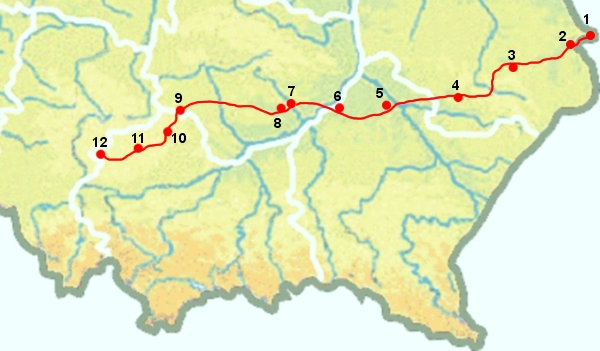
Map of LHS (Linia Hutnicza Szerokotorowa)
Author: Piotr Tysarczyk
Description
- Przejście graniczne Polski z Ukrainą w Gródku
- Hrubieszów
- Zamość
- Biłgoraj
- Nisko
- Wola Baranowska
- Staszów
- Grzybów
- Sędziszów
- Kępie
- Zarzecze
- Sławków
Licensing[edit]
This file is licensed under the Creative Commons Attribution-Share Alike 1.0 Generic license.
- You are free:
- to share – to copy, distribute and transmit the work
- to remix – to adapt the work
- Under the following conditions:
- attribution – You must give appropriate credit, provide a link to the license, and indicate if changes were made. You may do so in any reasonable manner, but not in any way that suggests the licensor endorses you or your use.
- share alike – If you alter, transform, or build upon this work, you must distribute the resulting work under the same license as the original.
File history
Click on a date/time to view the file as it appeared at that time.
| Date/Time | Thumbnail | Dimensions | User | Comment | |
|---|---|---|---|---|---|
| current | 14:58, 2 March 2006 | | 600 × 351 (244 KB) | Yuyudevil (talk | contribs) | optipng |
| 13:39, 2 March 2006 |  | 600 × 351 (618 KB) | Pitert (talk | contribs) | Map of LHS (Linia Hutnicza Szerokotorowa) Author: Piotr Tysarczyk Category:Maps of Poland |
You cannot overwrite this file.
File usage on Commons
The following page uses this file:
File usage on other wikis
The following other wikis use this file:
- Usage on cs.wikipedia.org
- Usage on de.wikipedia.org
- Usage on en.wikipedia.org
- Usage on es.wikipedia.org
- Usage on fr.wikipedia.org
- Usage on ja.wikipedia.org
- Usage on nl.wikipedia.org
- Usage on pl.wikipedia.org
- Usage on ru.wikipedia.org
- Usage on uk.wikipedia.org
- Usage on www.wikidata.org