File:Map showing countries President Uhuru Kenyatta of Kenya has visited.svg
Jump to navigation
Jump to search

Size of this PNG preview of this SVG file: 800 × 411 pixels. Other resolutions: 320 × 164 pixels | 640 × 329 pixels | 1,024 × 526 pixels | 1,280 × 657 pixels | 2,560 × 1,314 pixels | 863 × 443 pixels.
Original file (SVG file, nominally 863 × 443 pixels, file size: 1.55 MB)
Captions
Captions
Add a one-line explanation of what this file represents

Summary[edit]
| Description |
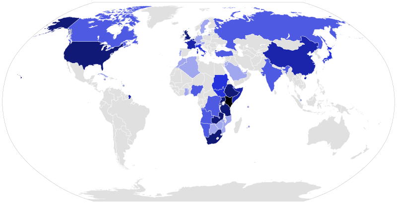
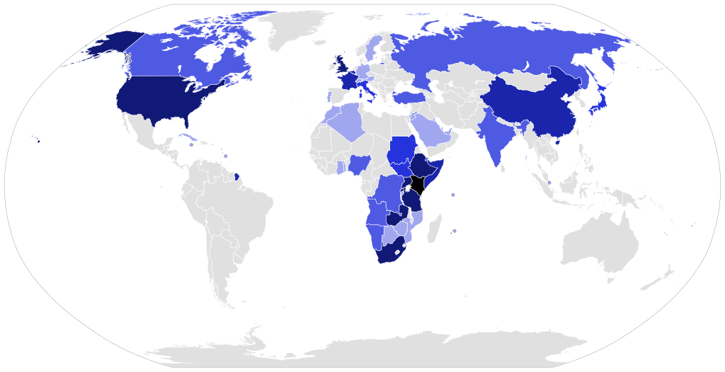
English: Map showing countries President Uhuru Kenyatta of Kenya has visited since his inauguration in 2013
1 Visit
2 Visits
3 Visits
4 Visits
5+ Visits
Kenya |
| Date | |
| Source | Own work |
| Author | Sputink |
Using BlankMap-World6.svg as a guide
Licensing[edit]
I, the copyright holder of this work, hereby publish it under the following license:
This file is licensed under the Creative Commons Attribution-Share Alike 4.0 International license.
- You are free:
- to share – to copy, distribute and transmit the work
- to remix – to adapt the work
- Under the following conditions:
- attribution – You must give appropriate credit, provide a link to the license, and indicate if changes were made. You may do so in any reasonable manner, but not in any way that suggests the licensor endorses you or your use.
- share alike – If you remix, transform, or build upon the material, you must distribute your contributions under the same or compatible license as the original.
File history
Click on a date/time to view the file as it appeared at that time.
| Date/Time | Thumbnail | Dimensions | User | Comment | |
|---|---|---|---|---|---|
| current | 22:28, 21 July 2022 | | 863 × 443 (1.55 MB) | Sputink (talk | contribs) | Added Trips from 2022 to July 21 |
| 00:02, 6 December 2021 |  | 863 × 443 (1.55 MB) | Sputink (talk | contribs) | Updated with 2021 changes, new Key | |
| 18:16, 20 July 2017 |  | 863 × 443 (1.55 MB) | Sputink (talk | contribs) | Updated to Late July 2017 | |
| 16:34, 1 March 2017 |  | 863 × 443 (1.55 MB) | Sputink (talk | contribs) | Added another Somalia visit | |
| 22:45, 10 January 2017 |  | 863 × 443 (1.55 MB) | Sputink (talk | contribs) | Added India 2017 visit | |
| 17:54, 24 November 2016 |  | 863 × 443 (1.55 MB) | Sputink (talk | contribs) | Added morocco visit | |
| 16:22, 31 October 2016 |  | 863 × 443 (1.55 MB) | Sputink (talk | contribs) | Added Sudan Visit | |
| 18:25, 14 October 2016 |  | 863 × 443 (1.55 MB) | Sputink (talk | contribs) | Added Togo Visit | |
| 16:14, 13 September 2016 |  | 863 × 443 (1.55 MB) | Sputink (talk | contribs) | Added Somalia Visit in September 2016 | |
| 10:00, 27 June 2016 |  | 863 × 443 (1.55 MB) | Sputink (talk | contribs) | Added Botswana June 27 Trip |
You cannot overwrite this file.
File usage on Commons
The following 2 pages use this file:
File usage on other wikis
The following other wikis use this file:
- Usage on en.wikipedia.org