File:Map of the city of Washington showing the progress of buildings up to October 1st 1873 LOC 87694487.jpg
Jump to navigation
Jump to search

Size of this preview: 685 × 600 pixels. Other resolutions: 274 × 240 pixels | 548 × 480 pixels | 877 × 768 pixels | 1,170 × 1,024 pixels | 2,339 × 2,048 pixels | 7,922 × 6,936 pixels.
Original file (7,922 × 6,936 pixels, file size: 7.13 MB, MIME type: image/jpeg)
Captions
Captions
Add a one-line explanation of what this file represents
Summary[edit]
| Description |
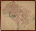
English: 15632D U.S. Copyright Office Also shows block numbers. "Equidistances 10 ft." "Entered according to Act of Congress in the year 1873 by J. Enthoffer in the Office of the Librarian of Congress at Washington." LC copy accompanied by information card dated 1973. 1 sheet ; 8 x 13 cm. LC copy 1 extensively annotated in ink and watercolor to show buildings and plan for Washington Monument grounds. LC copies 2, 3, and 4 variously annotated in pencil and ink to show additional buildings. LC copies variously faded, brittle, or torn. LC copies mounted on cloth backing. LC copy 1 edged with red cloth. Available also through the Library of Congress Web site as a raster image. 4 copies Vault DCP |
||
| Title | Map of the city of Washington showing the progress of buildings up to October 1st 1873 | ||
| Shelf ID | G3851.N23 1873 .E5 | ||
| Date | |||
| Source | https://www.loc.gov/item/87694487/ | ||
| Author | Enthoffer, J. (Joseph); Enthoffer, J. | ||
| Permission (Reusing this file) |
|
||
| Other versions |
|
||
| Location | United States · Washington D.C. · District Of Columbia · Washington | ||
| Part of | American Memory · Cities And Towns · Catalog · Geography And Map Division | ||
| Subject | Washington (D.C.) · Buildings · Maps, Topographic · Washington · United States · Maps · District Of Columbia · City Planning |

Licensing[edit]
|
This is a faithful photographic reproduction of a two-dimensional, public domain work of art. The work of art itself is in the public domain for the following reason:
The official position taken by the Wikimedia Foundation is that "faithful reproductions of two-dimensional public domain works of art are public domain".
This photographic reproduction is therefore also considered to be in the public domain in the United States. In other jurisdictions, re-use of this content may be restricted; see Reuse of PD-Art photographs for details. | ||||
File history
Click on a date/time to view the file as it appeared at that time.
| Date/Time | Thumbnail | Dimensions | User | Comment | |
|---|---|---|---|---|---|
| current | 15:59, 16 June 2018 | | 7,922 × 6,936 (7.13 MB) | Fæ (talk | contribs) | LOC Maps https://www.loc.gov/item/87694487/ #17597 |
You cannot overwrite this file.
File usage on Commons
The following page uses this file: