File:Map of the Routes of the Army of Africa - 1936 - He.png
Jump to navigation
Jump to search

Size of this preview: 494 × 599 pixels. Other resolutions: 198 × 240 pixels | 396 × 480 pixels | 633 × 768 pixels | 844 × 1,024 pixels | 1,383 × 1,678 pixels.
Original file (1,383 × 1,678 pixels, file size: 4.76 MB, MIME type: image/png)
Captions
Captions
Add a one-line explanation of what this file represents
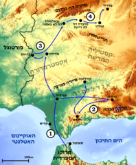
מתקפות לאומניות
![]() צבא אפריקה מוטס לסביליה (יולי-ספטמבר 1936)
צבא אפריקה מוטס לסביליה (יולי-ספטמבר 1936)
![]() הכוח העיקרי נע צפונה אל בדחוס ומרידה (אוגוסט 1936)
הכוח העיקרי נע צפונה אל בדחוס ומרידה (אוגוסט 1936)
![]() הכוח השני נע מערבה אל גרנדה (אוגוסט 1936)
הכוח השני נע מערבה אל גרנדה (אוגוסט 1936)
![]() הכוח העיקרי נע לכיוון צפון-מזרח אל מדריד דרך טולדו (ספטמבר-אוקטובר 1936)
הכוח העיקרי נע לכיוון צפון-מזרח אל מדריד דרך טולדו (ספטמבר-אוקטובר 1936)
Summary[edit]
| Description |
עברית: מפת התקדמות צבא אפריקה (1936) במלחמת האזרחים בספרד.
English: Hebrew map of the Routes of the Army of Africa (1936) in the Spanish Civil War. |
| Date | |
| Source | own work based on https://maps-for-free.com/ and File:1NumberOneInCircle whitebackground.png, File:2NumberTwoInCircle whitebackground.png, File:3NumberThreeInCircle whitebackground.png and File:4NumberFourInCircle whitebackground.png. |
| Author | Ariel196 |
Licensing[edit]
| This file is made available under the Creative Commons CC0 1.0 Universal Public Domain Dedication. | |
| The person who associated a work with this deed has dedicated the work to the public domain by waiving all of their rights to the work worldwide under copyright law, including all related and neighboring rights, to the extent allowed by law. You can copy, modify, distribute and perform the work, even for commercial purposes, all without asking permission.
|
File history
Click on a date/time to view the file as it appeared at that time.
| Date/Time | Thumbnail | Dimensions | User | Comment | |
|---|---|---|---|---|---|
| current | 18:14, 20 February 2020 | | 1,383 × 1,678 (4.76 MB) | Ariel196 (talk | contribs) | fixed Borders |
| 17:27, 20 February 2020 |  | 1,383 × 1,683 (4.76 MB) | Ariel196 (talk | contribs) | User created page with UploadWizard |
You cannot overwrite this file.
File usage on Commons
The following page uses this file:
File usage on other wikis
The following other wikis use this file:
- Usage on he.wikipedia.org