File:Map of the Kars-Akhalkalaki-Tbilisi-Baku railway.png
Jump to navigation
Jump to search

Size of this preview: 800 × 494 pixels. Other resolutions: 320 × 198 pixels | 640 × 395 pixels | 1,024 × 633 pixels | 1,280 × 791 pixels | 1,742 × 1,076 pixels.
Original file (1,742 × 1,076 pixels, file size: 2.34 MB, MIME type: image/png)
Captions
Captions
Add a one-line explanation of what this file represents
| Description |
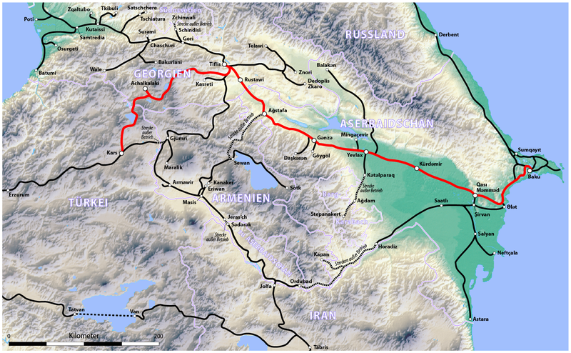
Deutsch: Karte der Bahnstrecke Kars–Achalkalaki–Tiflis–Baku (KATB)
English: Map of the Kars-Akhalkalaki-Tbilisi-Baku railway (KATB) |
||||||||||
| Date | see file history | ||||||||||
| Source |
own work, using the following files:
|
||||||||||
| Author | Maximilian Dörrbecker (Chumwa) | ||||||||||
| Permission (Reusing this file) |
I, the copyright holder of this work, hereby publish it under the following license: This file is licensed under the Creative Commons Attribution-Share Alike 2.5 Generic license.
|

File history
Click on a date/time to view the file as it appeared at that time.
| Date/Time | Thumbnail | Dimensions | User | Comment | |
|---|---|---|---|---|---|
| current | 06:02, 31 October 2017 | | 1,742 × 1,076 (2.34 MB) | Chumwa (talk | contribs) | |
| 09:41, 3 July 2011 |  | 1,742 × 1,076 (2.55 MB) | Chumwa (talk | contribs) | update | |
| 19:43, 25 May 2011 |  | 3,483 × 2,152 (5.47 MB) | Maphobbyist (talk | contribs) | Check | |
| 21:06, 23 May 2011 |  | 3,483 × 2,152 (5.47 MB) | Maphobbyist (talk | contribs) | The Azerbaijani Railways in the Azerbaijani exlave of Nakhchivan is still operational and is connected to Iran with daily services. It is operational almost the entire length of the railway track of Nakhchivan to the border towns from Sədərək in the no | |
| 17:06, 1 July 2009 |  | 3,483 × 2,152 (4.74 MB) | Chumwa (talk | contribs) | Nachitschwan → Berg-Karabach (danke an Oktopus3 für den Hinweis!) | |
| 05:51, 22 June 2009 |  | 3,483 × 2,152 (4.74 MB) | Chumwa (talk | contribs) | außer Betrieb befindliche Strecken überarbeitet | |
| 16:14, 21 June 2009 |  | 3,483 × 2,152 (4.7 MB) | Chumwa (talk | contribs) | diverse Anmerkungen von MBxd1 eingerbeitet, Nachitschewan eingezeichnet und dortige Strecken getilgt bzw. außer Dienst gestellt | |
| 12:36, 21 June 2009 |  | 1,742 × 1,076 (2.53 MB) | Chumwa (talk | contribs) | Bahnlinien nochmal anders dargestellt (danke an Lencer für den Vorschlag!) | |
| 10:33, 21 June 2009 |  | 1,742 × 1,076 (2.7 MB) | Chumwa (talk | contribs) | Hintergrundkarte bearbeitet, andere Streckendarstellung, tükische Bahnlinien überarbeitet | |
| 06:45, 21 June 2009 |  | 1,742 × 1,076 (2.67 MB) | Chumwa (talk | contribs) | Typos, Maßstabsleiste aus dem Rahmen direkt in die Karte gesetzt |
You cannot overwrite this file.
File usage on Commons
The following 7 pages use this file:
- User:Chumwa/Gallery
- User:Chumwa/OgreBot/Potential transport maps/2017 October 21-31
- User:Chumwa/OgreBot/Public transport information/2017 October 21-31
- User:Chumwa/OgreBot/Transport Maps/2017 October 21-31
- User:Chumwa/OgreBot/Travel and communication maps/2017 October 21-31
- User:Geagea/Israel/2017 October 31
- Category:Baku–Tbilisi–Kars railway
File usage on other wikis
The following other wikis use this file:
- Usage on ar.wikipedia.org
- Usage on de.wikipedia.org
- Usage on en.wikipedia.org
- Usage on kk.wikipedia.org
- Usage on ru.wikipedia.org
- Usage on tr.wikipedia.org
- Usage on www.wikidata.org