File:Map of the Imperial Circles (1512)-fr.svg
Jump to navigation
Jump to search

Size of this PNG preview of this SVG file: 610 × 599 pixels. Other resolutions: 244 × 240 pixels | 489 × 480 pixels | 782 × 768 pixels | 1,043 × 1,024 pixels | 2,085 × 2,048 pixels | 727 × 714 pixels.
Original file (SVG file, nominally 727 × 714 pixels, file size: 534 KB)
Captions
Captions
Add a one-line explanation of what this file represents
Summary
[edit]| Description |
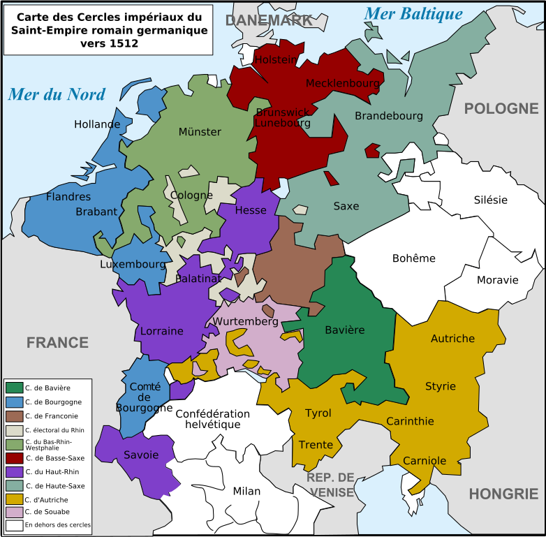
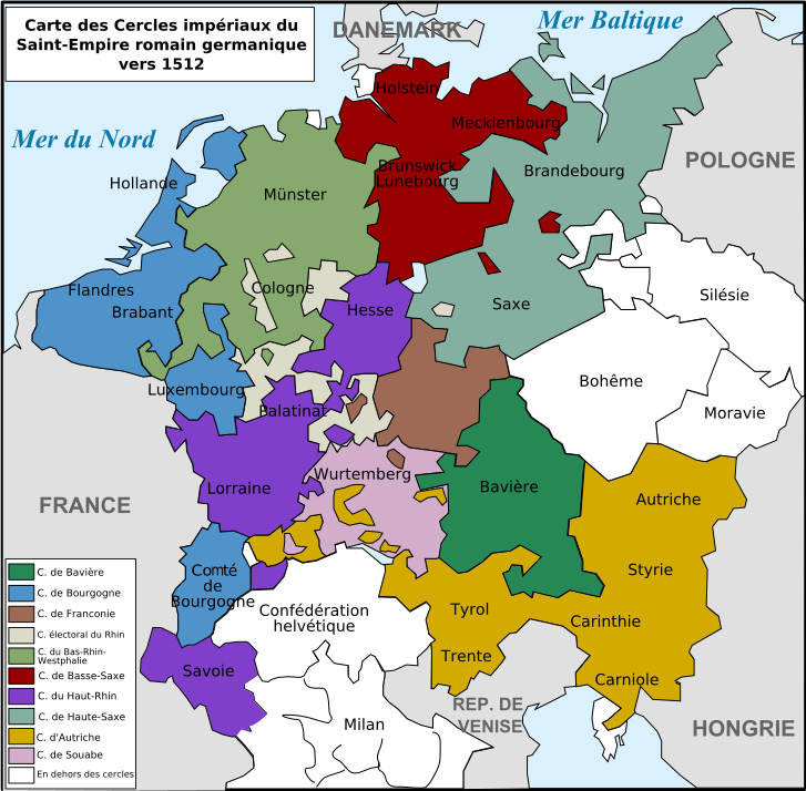
English: Map of the imperial circles of the Holy German Empire.
Français : Carte des cercles impériaux du Saint-Empire romain germanique au XVIe siècle.
Deutsch: Reichskreiseinteilung am Anfang des 16. Jahrhunderts. |
| Date | |
| Source | Own work |
| Author | Tinodela |
| Other versions |
[] 1512[edit]
1560[edit]
|
-bg.png)
-de.png)
-en.png)
-fr.svg)
.png)
-de.svg)
-en.svg)
-es.svg)
-la.svg)
-nl.svg)
-fr.svg&action=edit§ion=1)
Licensing
[edit]-fr.svg&action=edit§ion=2)
I, the copyright holder of this work, hereby publish it under the following licenses:

|
Permission is granted to copy, distribute and/or modify this document under the terms of the GNU Free Documentation License, Version 1.2 or any later version published by the Free Software Foundation; with no Invariant Sections, no Front-Cover Texts, and no Back-Cover Texts. A copy of the license is included in the section entitled GNU Free Documentation License. |
This file is licensed under the Creative Commons Attribution-Share Alike 3.0 Unported, 2.5 Generic, 2.0 Generic and 1.0 Generic license.
- You are free:
- to share – to copy, distribute and transmit the work
- to remix – to adapt the work
- Under the following conditions:
- attribution – You must give appropriate credit, provide a link to the license, and indicate if changes were made. You may do so in any reasonable manner, but not in any way that suggests the licensor endorses you or your use.
- share alike – If you remix, transform, or build upon the material, you must distribute your contributions under the same or compatible license as the original.
You may select the license of your choice.
File history
Click on a date/time to view the file as it appeared at that time.
| Date/Time | Thumbnail | Dimensions | User | Comment | |
|---|---|---|---|---|---|
| current | 14:56, 28 February 2020 | | 727 × 714 (534 KB) | 1Loupdesbois (talk | contribs) | Reverted to version as of 14:45, 28 February 2020 (UTC) |
| 14:56, 28 February 2020 |  | 727 × 714 (534 KB) | 1Loupdesbois (talk | contribs) | Correction de "Duché" de Bourgogne en Comté de Bourgogne. | |
| 14:45, 28 February 2020 |  | 727 × 714 (534 KB) | 1Loupdesbois (talk | contribs) | Correction du "Duché" de Bourgogne en Comté de Bourgogne. | |
| 22:19, 10 January 2014 |  | 727 × 714 (538 KB) | TKostolany (talk | contribs) | Savoie dans le haut-rhin | |
| 18:13, 22 August 2008 |  | 727 × 714 (538 KB) | Tinodela (talk | contribs) | {{Information |Description= |Source= |Date= |Author= |Permission= |other_versions= }} | |
| 18:09, 22 August 2008 |  | 727 × 714 (538 KB) | Tinodela (talk | contribs) | {{Information |Description= |Source= |Date= |Author= |Permission= |other_versions= }} | |
| 18:06, 22 August 2008 |  | 727 × 714 (538 KB) | Tinodela (talk | contribs) | {{Information |Description= |Source= |Date= |Author= |Permission= |other_versions= }} | |
| 18:04, 22 August 2008 |  | 727 × 714 (538 KB) | Tinodela (talk | contribs) | {{Information |Description={{en|1=Map of the imperial circles of the Holy German Empire.}} {{fr|1=Carte des cercles impériaux du Saint-Empire romain germanique au XVIe siècle.}} {{de|1=Reichskreiseinteilung am Anfang des 16. Jahrhunderts.}} |Source=trav |
You cannot overwrite this file.
File usage on Commons
The following 14 pages use this file:
- User:J budissin/Uploads/BiH/2020 February 20-29
- User:Magog the Ogre/Multilingual legend/2020 February 20-29
- File:Cerclesimperiaux.svg (file redirect)
- File:Map of the Imperial Circles (1512)-bg.png
- File:Map of the Imperial Circles (1512)-de.png
- File:Map of the Imperial Circles (1512)-en.png
- File:Map of the Imperial Circles (1512)-fr.svg
- File:Map of the Imperial Circles (1560)-de.svg
- File:Map of the Imperial Circles (1560)-en.svg
- File:Map of the Imperial Circles (1560)-es.svg
- File:Map of the Imperial Circles (1560)-la.svg
- File:Map of the Imperial Circles (1560)-nl.svg
- File:Német-római Birodalom körzetei (1512).png
- Template:Other versions/Map of the Imperial Circles
File usage on other wikis
The following other wikis use this file:
- Usage on ca.wikipedia.org
- Usage on fr.wikipedia.org
- 1512
- Saint-Empire romain germanique
- Histoire de l'Autriche
- Duché de Savoie
- Cercle de Bourgogne
- Cercle d'Autriche
- Cercle de Bavière
- Modèle:Palette Cercles impériaux
- Cercle du Bas-Rhin-Westphalie
- Cercle impérial
- Cercle de Franconie
- Cercle de Souabe
- Cercle électoral du Rhin
- Cercle de Basse-Saxe
- Cercle de Haute-Saxe
- Liste des territoires du Saint-Empire romain germanique
- Discussion:Liste des territoires du Saint-Empire romain germanique
- Cercle du Haut-Rhin
- Transaction d'Augsbourg
- Utilisateur:Fab5669/Essai/Essai 3
- Territoires du Saint-Empire romain germanique hors cercles impériaux
- Utilisateur:Mathious Ier/Histoire du Saint-Empire romain germanique
- Utilisateur:DreamcoatJoey/Brouillon/Liste Saint-Empire C-G
- Utilisateur:DreamcoatJoey/Brouillon/Liste Saint-Empire H-O
- Utilisateur:DreamcoatJoey/Brouillon/Liste Saint-Empire P-Z
- Liste des territoires du Saint-Empire (A)
- Utilisateur:DreamcoatJoey/Brouillon/Liste Saint-Empire (B)
- Liste des territoires du Saint-Empire (D)
- Liste des territoires du Saint-Empire (S)
- Liste des territoires du Saint-Empire (W)
- Liste des territoires du Saint-Empire (Z)
- Usage on oc.wikipedia.org
-fr.svg&oldid=638309594)