File:Map of the Far East and adjacent Pacific, recto.jpg
Jump to navigation
Jump to search

Size of this preview: 800 × 560 pixels. Other resolutions: 320 × 224 pixels | 640 × 448 pixels | 1,024 × 717 pixels | 1,280 × 896 pixels | 2,560 × 1,792 pixels | 4,701 × 3,290 pixels.
Original file (4,701 × 3,290 pixels, file size: 15.24 MB, MIME type: image/jpeg)
Captions
Captions
Add a one-line explanation of what this file represents
Summary[edit]
| Description |
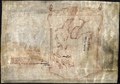
English: Map of the Far East and adjacent Pacific, recto. See also Did Marco Polo “Discover” America?, Smithsonian Magazine. 1 map : ms., vellum ; 22 x 19 cm., on sheet 29 x 41 cm. Call Number/Physical Location: G7800 .M3. Library of Congress Geography and Map Division Washington, D.C. 20540-4650 USA dcu
|
|||||||||||||||||||||||
| Date | 14th century | |||||||||||||||||||||||
| Source | https://www.loc.gov/item/2005633013/ [1], direct link | |||||||||||||||||||||||
| Author |
|
|||||||||||||||||||||||
| Other versions |
|
|||||||||||||||||||||||


Licensing[edit]
This media file is in the public domain in the United States. This applies to U.S. works where the copyright has expired, often because its first publication occurred prior to January 1, 1929, and if not then due to lack of notice or renewal. See this page for further explanation.
|
 | |
 |
This image might not be in the public domain outside of the United States; this especially applies in the countries and areas that do not apply the rule of the shorter term for US works, such as Canada, Mainland China (not Hong Kong or Macao), Germany, Mexico, and Switzerland. The creator and year of publication are essential information and must be provided. See Wikipedia:Public domain and Wikipedia:Copyrights for more details.
|
File history
Click on a date/time to view the file as it appeared at that time.
| Date/Time | Thumbnail | Dimensions | User | Comment | |
|---|---|---|---|---|---|
| current | 10:03, 11 July 2019 | | 4,701 × 3,290 (15.24 MB) | Yann (talk | contribs) | == {{int:filedesc}} == {{Information |Description={{en|Map of the Far East and adjacent Pacific, recto. See also [https://www.smithsonianmag.com/history/did-marco-polo-discover-america-180952765/ Did Marco Polo “Discover” America?], Smithsonian Magazine. 1 map : ms., vellum ; 22 x 19 cm., on sheet 29 x 41 cm. Call Number/Physical Location: G7800 .M3. Library of Congress Geography and Map Division Washington, D.C. 20540-4650 USA dcu * Library of Congress Control Number: 2005633013 * Languages:... |
You cannot overwrite this file.
File usage on Commons
The following 4 pages use this file: