File:Map of the Brazilian Empire WDL1035.png
Jump to navigation
Jump to search

Size of this preview: 590 × 599 pixels. Other resolutions: 236 × 240 pixels | 473 × 480 pixels | 827 × 840 pixels.
Original file (827 × 840 pixels, file size: 1.09 MB, MIME type: image/png)
Captions
Captions
Add a one-line explanation of what this file represents
Summary
[edit]
| Author |
Русский: Нимайер, Конрадо-Якоб-де (1788-1862)
Français : Niemeyer, Conrado Jacob de (1788-1862)
English: Niemeyer, Conrado Jacob de (1788-1862)
中文:尼迈耶, 康拉多·雅各布·德 (1788-1862)
Português: Niemeyer, Conrado Jacob de (1788-1862)
العربية: تورينهو, مونتيرو
Español: Niemeyer, Conrado Jacob de (1788-1862) |
| Title |
Русский: Карта Бразильской империи
Français : Carte de l'Empire brésilien
English: Map of the Brazilian Empire
中文:巴西帝国地图
Português: Mapa do Império Brasileiro
العربية: خريطة الإمبراطورية البرازيلية
Español: Mapa del Imperio brasileño |
| Description |
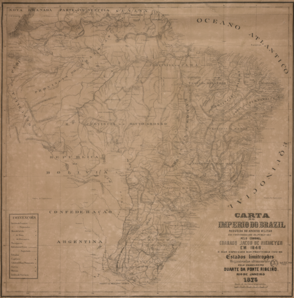
Русский: Данная подробная карта Императорской Бразилии была составлена Конрадо Жакобом Нимейером (1788-1862 гг.) по образцу более ранней карты, составленной Дуарте да Понте Рибейро, бароном Понте Рибейро (1795-1878 гг.). Начав свою карьеру в качестве врача, Понте Рибейро стал выдающимся дипломатом в ранний период независимости Бразилии и представлял свою страну в Португалии, Мексике, Перу, Боливии и Аргентине. Нимейер был инженером, наиболее известным благодаря строительству (за свой собственный счет) главной дороги, соединяющей различные районы Рио-де-Жанейро; в настоящее время эта дорога носит его имя.
Административно-территориальное деление; Границы; Бразилия -- История -- Империя, 1822-1889 гг. Français : Cette carte détaillée du Brésil impérial a été dressée par Niemeyer Conrado Jacob (1788-1862), d'après une carte précédente de Duarte da Ponte Ribeiro, baron de Ponte Ribeiro (1795-1878). Après avoir commencé sa carrière en tant que médecin, Ponte Ribeiro est devenu un haut diplomate pendant les premières années de l'indépendance du Brésil. Il a représenté son pays au Portugal, au Mexique, au Pérou, en Bolivie et en Argentine. Niemeyer était un ingénieur essentiellement connu pour la construction, à ses propres frais, d'une grande route reliant les différents quartiers de Rio de Janeiro ; cette route porte aujourd'hui son nom.
Divisions administratives et politiques; Frontières; Brésil -- Histoire -- Empire, 1822-1889 English: This detailed map of Imperial Brazil was drawn by Conrado Jacob Niemeyer (1788-1862) after an earlier map by Duarte da Ponte Ribeiro, the Baron of Ponte Ribeiro (1795-1878). After beginning his career as a doctor, Ponte Ribeiro became an important diplomat during the early years of Brazilian independence, representing his country in Portugal, Mexico, Peru, Bolivia, and Argentina. Niemeyer was an engineer best known for constructing, at his own expense, a major road connecting the different districts of Rio de Janeiro; this road now bears his name.
Administrative and political divisions; Borders; Brazil -- History -- Empire, 1822-1889 中文:这幅巴西帝国的详细地图出自康拉多·雅各布·尼迈耶(1788-1862 年),基于杜阿尔特·达·蓬特·里贝罗,蓬特·里贝罗男爵(1795-1878 年)的一幅早期地图制作而成。 蓬特·里贝罗在开始他的医生生涯之前,在巴西独立早期是一名重要的外交官,代表国家在葡萄牙、墨西哥、秘鲁、玻利维亚以及阿根廷处理事务。 尼迈耶是一名工程师,他以自费建造一条连接里约热内卢数个不同地区的干道而闻名于世,目前该道路已其姓名而命名。
行政与政治划分; 边界; 巴西-历史-帝国,1822 - 1889 年 Português: Este mapa detalhado do Brasil Imperial foi desenhado por Conrado Jacob Niemeyer (1788-1862) baseado em um mapa anterior de Duarte da Ponte Ribeiro, o Barão de Ponte Ribeiro (1795-1878). Após iniciar sua carreira como médico, Ponte Ribeiro tornou-se um importante diplomata durante os primeiros anos da Independência do Brasil, representando seu país em Portugal, México, Peru, Bolívia e Argentina. Niemeyer foi um engenheiro que ficou mais conhecido pela construção, às próprias custas, de uma das principais estradas que ligam os diversos bairros do Rio de Janeiro; esta estrada hoje leva seu nome.
Divisões políticas e administrativas; Fronteiras; Brasil - História - Império, 1822-1889 العربية: رسم هذه الخريطة المفصلة لامبراطورية البرازيل كونرادو يعقوب نيمير (1788-1862 ) استنادا إلى خريطة سابقة أعدها دوارتي دا بونتي ريبيرو، بارون بونتي ريبيرو (1795-1878). وكان بونتي ريبيرو قد بدأ حياته المهنية طبيًبا، إلا أنه أصبح دبلوماسيًا هامًا خلال السنوات الأولى من استقلال البرازيل، حيث مثل بلاده في البرتغال، والمكسيك ،وبيرو، وبوليفيا، والأرجنتين. وكان نيمير مهندساً، أفضل ما يُعرف به بناء طريق رئيسي يربط بين مناطق مختلفة في ريو دي جانيرو. وقد بنى هذا الطريق على نفقنه الخاصة؛ وهي تحمل اسمه الآن.
الأقسام الإدارية والسياسية; الحدود; البرازيل -- تاريخ -- الإمبراطورية، 1822-1889 Español: Este mapa detallado de Brasil Imperial fue dibujado por Conrado Jacob Niemeyer (1788-1862) basado en un mapa anterior de Duarte da Ponte Ribeiro, el Barón de Ponte Ribeiro (1795-1878). Después de comenzar su carrera como médico, Ponte Ribeiro se convirtió en un importante diplomático durante los primeros años de la independencia brasileña, y representó a su país en Portugal, México, Perú, Bolivia y Argentina. Niemeyer era un ingeniero más conocido por la construcción, a sus expensas, de una carretera principal que conectaba los diferentes barrios de Río de Janeiro; esta carretera ahora lleva su nombre.
Divisiones políticas y administrativas; Fronteras; Brasil - Historia - Imperio, 1822-1889 |
| Date | 1873 |
| Medium |
Русский: Карты
Français : Cartes
English: Maps
中文:地图
Português: Mapas
العربية: خرائط
Español: Mapas |
| Dimensions |
English: 1 map ; 64 x 63 centimeters |
| Collection |
Русский: Национальная библиотека Бразилии
Français : Bibliothèque nationale du Brésil
English: National Library of Brazil
中文:巴西国家图书馆
Português: Biblioteca Nacional do Brasil
العربية: مكتبة البرازيل الوطنية
Español: Biblioteca Nacional de Brasil |
| Place of creation |
Русский: Бразилия
Français : Brésil
English: Brazil
中文:巴西
Português: Brasil
العربية: البرازيل
Español: Brasil |
| Notes | Original language title: Carta do Império do Brasil |
| References | http://hdl.loc.gov/loc.wdl/brrjbn.1035 |
| Source/Photographer |
|
Licensing
[edit]
|
This is a faithful photographic reproduction of a two-dimensional, public domain work of art. The work of art itself is in the public domain for the following reason:
The official position taken by the Wikimedia Foundation is that "faithful reproductions of two-dimensional public domain works of art are public domain".
This photographic reproduction is therefore also considered to be in the public domain in the United States. In other jurisdictions, re-use of this content may be restricted; see Reuse of PD-Art photographs for details. | ||||
File history
Click on a date/time to view the file as it appeared at that time.
| Date/Time | Thumbnail | Dimensions | User | Comment | |
|---|---|---|---|---|---|
| current | 14:08, 18 April 2023 | | 827 × 840 (1.09 MB) | Enyavar (talk | contribs) | Cropped 20 % horizontally, 18 % vertically, rotated -0.4° using CropTool with precise mode. |
| 13:17, 10 March 2014 |  | 1,029 × 1,024 (1.61 MB) | Fæ (talk | contribs) | =={{int:filedesc}}== {{Artwork |artist = |author ={{ru|1=Нимайер, Конрадо-Якоб-де (1788-1862)}} {{fr|1=Niemeyer, Conrado Jacob de (1788-1862)}} {{en|1=Niemeyer, Conrado Jacob de (1788-1862)}} {{zh|1=尼迈耶, 康拉多·雅各布·... |
You cannot overwrite this file.
File usage on Commons
The following page uses this file: