File:Map of rail routes between Liverpool and Manchester in 1960.svg
Jump to navigation
Jump to search

Size of this PNG preview of this SVG file: 702 × 318 pixels. Other resolutions: 320 × 145 pixels | 640 × 290 pixels | 1,024 × 464 pixels | 1,280 × 580 pixels | 2,560 × 1,160 pixels.
Original file (SVG file, nominally 702 × 318 pixels, file size: 1.33 MB)
Captions
Captions
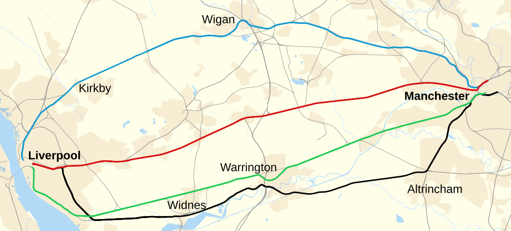
Map of rail routes between Liverpool and Manchester in 1960
Summary
[edit]
| Description |
English: Map showing railway routes in 1960 between Liverpool and Manchester in England. See Liverpool–Manchester lines.
Via Kirkby and Wigan (Route no longer direct; passengers must change at Kirkby.)
Northern route (Chat Moss)
Southern route (Cheshire Lines Committee) (Route within Liverpool now follows the black route.)
Via Ditton Junction (Tracks no longer exist between Warrington and Altrincham.)
Other lines |
| Date | |
| Source | Derived from https://www.openstreetmap.org/#map=9/53.8663/-2.3978 accessed 28 April 2021. |
| Author |
|
References
[edit]
- Ordnance Survey One Inch 7th series maps 1952–1961, accessed via National Library of Scotland website]
Licensing
[edit]
| This work contains information from OpenStreetMap, which is made available under the Open Database License (ODbL).
The ODbL does not require any particular license for maps produced from ODbL data. Prior to 1 August 2020, map tiles produced by the OpenStreetMap Foundation were licensed under the CC-BY-SA-2.0 license. Maps produced by other people may be subject to other licences. |
This file is licensed under the Creative Commons Attribution-Share Alike 4.0 International license.
Attribution: © OpenStreetMap contributors and Dr Greg
- You are free:
- to share – to copy, distribute and transmit the work
- to remix – to adapt the work
- Under the following conditions:
- attribution – You must give appropriate credit, provide a link to the license, and indicate if changes were made. You may do so in any reasonable manner, but not in any way that suggests the licensor endorses you or your use.
- share alike – If you remix, transform, or build upon the material, you must distribute your contributions under the same or compatible license as the original.
File history
Click on a date/time to view the file as it appeared at that time.
| Date/Time | Thumbnail | Dimensions | User | Comment | |
|---|---|---|---|---|---|
| current | 12:40, 27 June 2022 | | 702 × 318 (1.33 MB) | Dr Greg (talk | contribs) | more accurate locations for Liverpool terminii |
| 21:23, 25 June 2022 |  | 702 × 318 (1.33 MB) | Dr Greg (talk | contribs) | better location for Manchester Victoria | |
| 15:28, 25 June 2022 |  | 328 × 148 (1.33 MB) | Dr Greg (talk | contribs) | Uploaded a work by * OpenStreetMap: [http://www.openstreetmap.org/copyright OpenStreetMap contributors] * derivative work: Dr Greg from Derived from https://www.openstreetmap.org/#map=9/53.8663/-2.3978 accessed 28 April 2021. with UploadWizard |
You cannot overwrite this file.
File usage on Commons
The following 3 pages use this file:
File usage on other wikis
The following other wikis use this file:
- Usage on en.wikipedia.org
Metadata
Categories:
- Liverpool to Manchester Lines
- Rail transport maps of Merseyside
- Disused railway lines in Merseyside
- History of Merseyside
- Rail transport maps of Greater Manchester
- Disused railway lines in Greater Manchester
- History of Greater Manchester
- Rail transport maps of Cheshire
- OpenStreetMap maps of North West England
- Maps of the history of Lancashire