File:Map of part of the North West Territory including the Province of Manitoba.jpg

Original file (11,618 × 4,842 pixels, file size: 12.38 MB, MIME type: image/jpeg)
Captions
Captions
Summary[edit]
| Description |
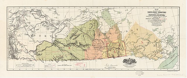
English: Map of part of the North West Territory including the Province of Manitoba exhibiting the several tracts of country ceded by the Indian Treaties 1, 2, 3 and 4: to accompany report of the Honble. the Minister of the Interior dated 20th January, 1875.
Ottawa: Department of the Interior, 1875 (20th Jan.). Physical description: 1 map : col. ; 33.6 x 91.3 cm. on sheet 40.8 x 98.6 cm. Language: English Scale: [ca. 1:2,217,600]. 1 inch = 35 miles Gives Indian populations under the four treaties and spatial references such as Mounted Police stations and Indian reserves. "Authorities: East of the 101st Meridian, from General Map of the Canadian Pacific Railway of 1874; West of the 101st Meridian from Captain Palliser's Map of B.N. America, 1860; Vicinity of 49th Parallel, Surveys of N.A. Boundary Commission of 1872-84." |
| Date | |
| Source | Peel's Prarie Provinces map collection http://peel.library.ualberta.ca/maps/M000461.html |
| Creator |
J. Johnston |
| Geotemporal data | |
| Scale | 1:2,217,600 |
| Georeferencing | If inappropriate please set warp_status = skip to hide. |
| Bibliographic data | |
| Language | English |
Licensing[edit]
This Canadian work is in the public domain in Canada because its copyright has expired due to one of the following:
it was not subject to Crown copyright, and
|
 |
File history
Click on a date/time to view the file as it appeared at that time.
| Date/Time | Thumbnail | Dimensions | User | Comment | |
|---|---|---|---|---|---|
| current | 19:48, 9 September 2020 | | 11,618 × 4,842 (12.38 MB) | Viola-Ness (talk | contribs) | Uploaded a work by J. Johnston from Peel's Prarie Provinces map collection http://peel.library.ualberta.ca/maps/M000461.html with UploadWizard |
You cannot overwrite this file.
File usage on Commons
There are no pages that use this file.