File:Map of Russia - Volga Federal District (2018 composition).svg
Jump to navigation
Jump to search

Size of this PNG preview of this SVG file: 800 × 462 pixels. Other resolutions: 320 × 185 pixels | 640 × 369 pixels | 1,024 × 591 pixels | 1,280 × 738 pixels | 2,560 × 1,477 pixels | 1,092 × 630 pixels.
Original file (SVG file, nominally 1,092 × 630 pixels, file size: 61 KB)
Captions
Captions
Add a one-line explanation of what this file represents
Summary
[edit].svg&action=edit§ion=1)
| Description |
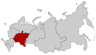
English: Map Russia highlighting the Volga Federal district as of 2018-11-03.. Español: Ubicación del Distrito Federal del Volga en la Federación Rusa Русский: Приволжский федеральный округ |
| Date | (UTC) |
| Source |
This file was derived from: |
| Author |
.svg)
| This is a retouched picture, which means that it has been digitally altered from its original version. Modifications: Far Eastern-Siberian border update as of November. The original can be viewed here: Map of Russia - Far Eastern Federal District (2018 composition).svg:
|
Licensing
[edit].svg&action=edit§ion=2)
This file is licensed under the Creative Commons Attribution-Share Alike 2.5 Generic license.
- You are free:
- to share – to copy, distribute and transmit the work
- to remix – to adapt the work
- Under the following conditions:
- attribution – You must give appropriate credit, provide a link to the license, and indicate if changes were made. You may do so in any reasonable manner, but not in any way that suggests the licensor endorses you or your use.
- share alike – If you remix, transform, or build upon the material, you must distribute your contributions under the same or compatible license as the original.
Original upload log
[edit].svg&action=edit§ion=3)
This image is a derivative work of the following images:
- File:Map of Russia - Volga Federal District.svg licensed with Cc-by-sa-2.5
- 2015-03-10T14:21:00Z Knyaz-1988 1092x630 (97490 Bytes) Reverted to version as of 22:11, 3 November 2014
- 2014-11-04T01:28:52Z Fry1989 1092x630 (121238 Bytes) NPOV issue.
- 2014-11-03T22:11:59Z Knyaz-1988 1092x630 (97490 Bytes) New version
- 2011-03-05T11:20:21Z SEVEREN 1092x630 (121238 Bytes) {{Information |Description ={{en|1=Map Russia highlighting the Volga [[:en:Federal districts of Russia|Federal districts]]}} {{es|1=Ubicación del Distrito Federal del Volga en la Federación Rusa}} {{ru|1=Приволжс
- 2010-01-21T22:28:52Z Denhud 1092x630 (122790 Bytes) On 2010-01-19 Southern Federal District split in two, with its former southern territories forming new North Caucasian Federal District.
- 2008-03-03T23:37:13Z Lokal Profil 1092x630 (114976 Bytes) {{Information |Description=Map Russia highlighting the Volga [[:en:Federal districts of Russia|Federal districts]]. |Source=Based on [[:Image:Map of Russian subjects, 2008-03-01.svg|Map of Russian subjects, 2008-03-01.svg]] b
- File:Map of Russia - Far Eastern Federal District (2018 composition).svg licensed with Cc-by-sa-2.5
- 2018-11-04T19:15:28Z Seryo93 1092x630 (62312 Bytes) == {{int:filedesc}} == {{Information |Description={{en|Map Russia highlighting the '''Far Eastern [[:en:Federal districts of Russia|Federal district]]''' as of 2018-11-03.}} {{es|Ubicación del Distrito Federal de Lejano Orie
Uploaded with derivativeFX
File history
Click on a date/time to view the file as it appeared at that time.
| Date/Time | Thumbnail | Dimensions | User | Comment | |
|---|---|---|---|---|---|
| current | 13:52, 2 December 2018 | | 1,092 × 630 (61 KB) | Seryo93 (talk | contribs) | == {{int:filedesc}} == {{Information |Description={{en|Map Russia highlighting the Volga Federal district as of 2018-11-03..}} {{es|Ubicación del Distrito Federal del Volga en la Federación Rusa}} {{Ru|Приволжский федеральный округ}} |Source={{Derived from|Map of Russia - Volga Federal District.svg|Map of Russia - Far Eastern Federal District (2018 composition).svg|display=50}} |Date=2018-12-02 13:51 (UTC) |Author= * [[:File:Map of Russia - Volga Federal Di... |
You cannot overwrite this file.
File usage on Commons
The following page uses this file:
File usage on other wikis
The following other wikis use this file:
- Usage on azb.wikipedia.org
- Usage on bn.wikipedia.org
- Usage on cs.wikipedia.org
- Usage on en.wikipedia.org
- Usage on en.wikinews.org
- Usage on fa.wikipedia.org
- Usage on fi.wikipedia.org
- Usage on frr.wikipedia.org
- Usage on fr.wikipedia.org
- Usage on lld.wikipedia.org
- Usage on lt.wikipedia.org
- Usage on lv.wikipedia.org
- Usage on no.wikipedia.org
- Usage on ru.wikipedia.org
- Usage on sl.wikipedia.org
- Usage on ta.wikipedia.org
- Usage on uz.wikipedia.org
- Usage on vi.wikipedia.org
- Usage on wuu.wikipedia.org
.svg&oldid=593355551)