File:Map of Port Pirie railways, stations and Coonamia stopping place.png

Original file (1,706 × 1,536 pixels, file size: 2.19 MB, MIME type: image/png)
Captions
Captions
Summary
[edit]
| Description |
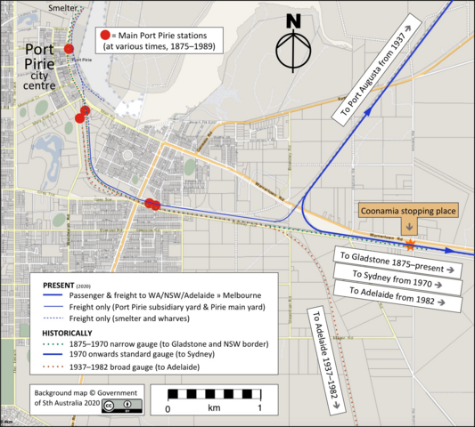
English: The map has been prepared to supplement the Wikipedia article on Coonamia railway station, illustrating the evolution of railway gauges in the city of Port Pirie and the resulting use of the "station" at Coonamia. |
| Date | |
| Source |
Background map: South Australian Property and Planning Atlas -- https://maps.sa.gov.au/SAPPA/ Railway lines, stations and annotations, SCHolar44. |
| Author | South Australian Government Department of Planning, Transport and Infrastructure GIS Office. |
| Camera location | | View this and other nearby images on: OpenStreetMap |
|---|
Copyright in the background map is owned by the South Australian Government, which is a participant in the Open Government Initiative, whereby public sector information is licensed under CC BY 4.0 International. This is confirmed on the Help menu of the Department of Planning, Transport and Infrastructure's LocationSAMapViewer website (https://location.sa.gov.au/viewer/). Additional work (railway lines, stations and annotations) are by SCHolar44, CC0.
Licensing
[edit]
- You are free:
- to share – to copy, distribute and transmit the work
- to remix – to adapt the work
- Under the following conditions:
- attribution – You must give appropriate credit, provide a link to the license, and indicate if changes were made. You may do so in any reasonable manner, but not in any way that suggests the licensor endorses you or your use.
File history
Click on a date/time to view the file as it appeared at that time.
| Date/Time | Thumbnail | Dimensions | User | Comment | |
|---|---|---|---|---|---|
| current | 03:45, 19 December 2019 | | 1,706 × 1,536 (2.19 MB) | SCHolar44 (talk | contribs) | User created page with UploadWizard |
You cannot overwrite this file.
File usage on Commons
There are no pages that use this file.
File usage on other wikis
The following other wikis use this file:
- Usage on en.wikipedia.org