File:Map of Ioannina prefecture.svg
Jump to navigation
Jump to search

Size of this PNG preview of this SVG file: 424 × 600 pixels. Other resolutions: 170 × 240 pixels | 339 × 480 pixels | 543 × 768 pixels | 724 × 1,024 pixels | 1,448 × 2,048 pixels | 744 × 1,052 pixels.
Original file (SVG file, nominally 744 × 1,052 pixels, file size: 938 KB)
Captions
Captions
Add a one-line explanation of what this file represents
| Description |
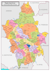
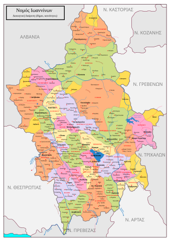
English: Map of Ioannina prefecture, Greece Ελληνικά: Χάρτης του Νομού Ιωαννίνων με κοινότητες, δήμους, έδρες δήμων, δημοτικά διαμερίσματα, οικισμούς, ποτάμια και βουνά. Φτιάχτηκε από εμένα τον ίδιο χειροποίητα στο inkscape. Στοιχεία συλλέχτηκαν από το υπουργείο εσωτερικών σχετικά με το πρόγραμμα "Ιωάννης Καποδίστριας", από τους χάρτες του Google αλλά και από δορυφορικές εικόνες του Google Earth. Τα στοιχεία μπήκαν χειροποίητα στο inkscape μιας και σχεδόν όλα τα στοιχεία που συλλέχτηκαν δεν ήταν σε ανυσματική μορφή αλλά σε bitmap. Δεν είναι χάρτης ακριβείας αλλά κατασκευάστηκε περισσότερο για εκπαιδευτικούς σκοπούς. |
| Date | |
| Source |
Own work; transferred from el.wikipedia; transferred to Commons by User:MARKELLOS using CommonsHelper. |
| Author | Leftezi |
| Permission (Reusing this file) |
CC-BY-SA-2.5 |
Licensing[edit]
This file is licensed under the Creative Commons Attribution-Share Alike 2.5 Generic license.
- You are free:
- to share – to copy, distribute and transmit the work
- to remix – to adapt the work
- Under the following conditions:
- attribution – You must give appropriate credit, provide a link to the license, and indicate if changes were made. You may do so in any reasonable manner, but not in any way that suggests the licensor endorses you or your use.
- share alike – If you remix, transform, or build upon the material, you must distribute your contributions under the same or compatible license as the original.
Original upload log[edit]
The original description page was here. All following user names refer to el.wikipedia.
- 2007-10-24 23:23 Leftezi 744×1052× (960714 bytes) {{Πληροφορίες εικόνας |Περιγραφή= |Πηγή= |Ημερομηνία= |Δημιουργός= |Άδεια χρήσης= }}
- 2007-10-24 23:20 Leftezi 744×1052× (984829 bytes) {{Πληροφορίες εικόνας |Περιγραφή= Χάρτης του Νομού Ιωαννίνων με κοινότητες, δήμους, έδρες δήμων, δημοτικά διαμερίσματα, οικισμούς, ποτάμια κ
- 2007-10-16 23:09 Leftezi 744×1052× (1456824 bytes) {{Πληροφορίες εικόνας |Περιγραφή= |Πηγή= |Ημερομηνία= |Δημιουργός= |Άδεια χρήσης= }}
- 2007-10-15 23:23 Leftezi 744×1052× (1456813 bytes) {{Πληροφορίες εικόνας |Περιγραφή= Χάρτης του Νομού Ιωαννίνων με κοινότητες, δήμους, έδρες δήμων, δημοτικά διαμερίσματα, οικισμούς, ποτάμια κ
- 2007-10-15 02:24 Leftezi 744×1052× (1464764 bytes) {{Πληροφορίες εικόνας |Περιγραφή= Χάρτης του Νομού Ιωαννίνων με κοινότητες, δήμους, έδρες δήμων, δημοτικά διαμερίσματα, οικισμούς, ποτάμια κ
File history
Click on a date/time to view the file as it appeared at that time.
| Date/Time | Thumbnail | Dimensions | User | Comment | |
|---|---|---|---|---|---|
| current | 15:41, 8 March 2010 | | 744 × 1,052 (938 KB) | File Upload Bot (Magnus Manske) (talk | contribs) | {{BotMoveToCommons|el.wikipedia|year={{subst:CURRENTYEAR}}|month={{subst:CURRENTMONTHNAME}}|day={{subst:CURRENTDAY}}}} {{Information |Description={{el|Χάρτης του Νομού Ιωαννίνων με κοινότητες, δήμους, έδρες � |
You cannot overwrite this file.
File usage on Commons
There are no pages that use this file.
File usage on other wikis
The following other wikis use this file:
- Usage on ja.wikipedia.org