File:Map of European states and nationalities in 1917 (without caption).jpg
Jump to navigation
Jump to search

Size of this preview: 692 × 600 pixels. Other resolutions: 277 × 240 pixels | 554 × 480 pixels | 887 × 768 pixels | 1,182 × 1,024 pixels | 1,878 × 1,627 pixels.
Original file (1,878 × 1,627 pixels, file size: 1.41 MB, MIME type: image/jpeg)
Captions
Captions
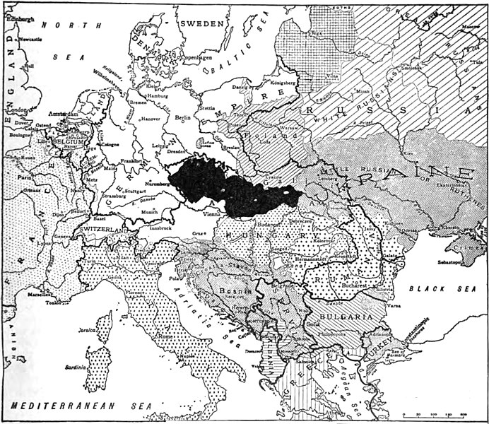
Map of boundaries between European states and nationalities, published in The Bohemian Review, vol. 1, no. 1 (1917)
Summary[edit]
| Description |
English: Map of boundaries between European states and nationalities, published in The Bohemian Review, vol. 1, no. 1 (1917), without caption
Čeština: Mapa hranic mezi evropskými státy a národnostmi, zveřejněná v The Bohemian Review, roč. 1., č. 1 (1917), bez popisku |
| Date | |
| Source | Extracted from The Bohemian Review, vol. 1, no. 1 (1917), page 9. |
| Author | Unknown author |
| Other versions |

.jpg&action=edit§ion=1)
Licensing[edit]
.jpg&action=edit§ion=2)
This work is in the public domain in the United States because it was published (or registered with the U.S. Copyright Office) before January 1, 1929.
Public domain works must be out of copyright in both the United States and in the source country of the work in order to be hosted on the Commons. If the work is not a U.S. work, the file must have an additional copyright tag indicating the copyright status in the source country.
Note: This tag should not be used for sound recordings. |
File history
Click on a date/time to view the file as it appeared at that time.
| Date/Time | Thumbnail | Dimensions | User | Comment | |
|---|---|---|---|---|---|
| current | 13:27, 30 October 2019 | | 1,878 × 1,627 (1.41 MB) | Jan.Kamenicek (talk | contribs) | User created page with UploadWizard |
You cannot overwrite this file.
File usage on Commons
The following page uses this file:
File usage on other wikis
The following other wikis use this file:
- Usage on en.wikisource.org
.jpg&oldid=670190213)