File:Map of Ancient Rome 271 AD heb.png
Jump to navigation
Jump to search

Size of this preview: 800 × 473 pixels. Other resolutions: 320 × 189 pixels | 640 × 379 pixels | 1,024 × 606 pixels | 1,280 × 757 pixels | 2,050 × 1,213 pixels.
Original file (2,050 × 1,213 pixels, file size: 320 KB, MIME type: image/png)
Captions
Captions
Add a one-line explanation of what this file represents
Summary[edit]
| Description |
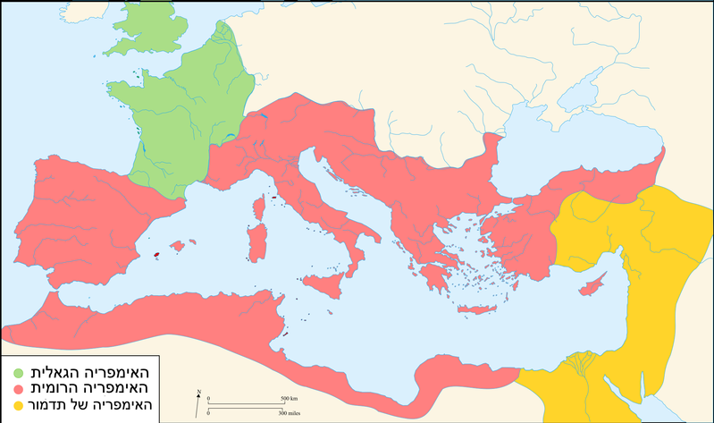
English: Map of the Roman Empire around the year of the consulship of Aurelianus and Bassus (271 AD), with the break away Gallic Empire in the West and the Palmyrene Empire in the East.
מפה של האימפריה הרומית בתחילת העשור השמיני של המאה השלישית |
| Date | |
| Source | File:Map_of_Ancient_Rome_271_AD.svg |
| Author | User:nettadi |
Licensing[edit]
This file is licensed under the Creative Commons Attribution-Share Alike 2.5 Generic license.
- You are free:
- to share – to copy, distribute and transmit the work
- to remix – to adapt the work
- Under the following conditions:
- attribution – You must give appropriate credit, provide a link to the license, and indicate if changes were made. You may do so in any reasonable manner, but not in any way that suggests the licensor endorses you or your use.
- share alike – If you remix, transform, or build upon the material, you must distribute your contributions under the same or compatible license as the original.
Original upload log[edit]
This image is a derivative work of the following images:
The original description page was here. All following user names refer to en.wikipedia.
- 2007-11-07 02:47 Justinian43 524×377×8 (26490 bytes) The Mediterranean by 271 A.D -The [[Roman Empire]]. -The breakaway [[Gallic Empire]]. -The breakaway [[Palmyrene Empire]].
- derivative work: Pomalee (talk)
other_versions=Derivative works of this file: Map of Ancient Rome 271 AD-sr.svg Permission= GNU Free Documentation License, Version 1.2, Creative Commons Attribution-ShareAlike license versions 3.0, 2.5, 2.0, and 1.0
- Romanworld271AD.jpg: User:Justinian43, uploaded by User:El_bes
| This is a retouched picture, which means that it has been digitally altered from its original version. Modifications: Used "Blank_map_of_South_Europe_and_North_Africa.svg" to refashion "Romanworld271.jpg". The original can be viewed here: Romanworld271AD.jpg:
|

|
Permission is granted to copy, distribute and/or modify this document under the terms of the GNU Free Documentation License, Version 1.2 or any later version published by the Free Software Foundation; with no Invariant Sections, no Front-Cover Texts, and no Back-Cover Texts. A copy of the license is included in the section entitled GNU Free Documentation License. |
| This file is licensed under the Creative Commons Attribution-Share Alike 3.0 Unported license. | ||
| ||
| This licensing tag was added to this file as part of the GFDL licensing update. |
- File:Blank_map_of_South_Europe_and_North_Africa.svg licensed with Cc-by-sa-2.5,2.0,1.0, GFDL
- 2007-08-09T20:26:49Z Historicair 2050x1213 (1260388 Bytes)
- 2007-08-09T16:12:00Z Historicair 2050x1213 (351130 Bytes) {{Improving}} {{Information |Description={{fr}}Carte vierge de l'Europe du Sud et du Bassin Méditerranée dans l'Antiquité {{en}}Blank map of South Europe and North Africa at Antic period |Source=Own work + [[Image:Blank map of South Europe and North Africa.svg]] by myself
- File:Romanworld271AD.jpg licensed with GFDL-en
- 2007-11-20T15:23:56Z El bes 524x377 (26490 Bytes) {{Information |Description= The Roman Empire around the year 271 AD, with the break awai Gallic Empire in the West |Source= http://en.wikipedia.org/wiki/Image:Romanworld271AD.JPG |Date= November 20th, 2007 |Author= [[http://e
File history
Click on a date/time to view the file as it appeared at that time.
| Date/Time | Thumbnail | Dimensions | User | Comment | |
|---|---|---|---|---|---|
| current | 15:04, 6 October 2017 | | 2,050 × 1,213 (320 KB) | Nettadi (talk | contribs) | User created page with UploadWizard |
You cannot overwrite this file.
File usage on Commons
The following 18 pages use this file:
- User:J budissin/Uploads/BiH/2017 October 1-10
- File:Carte empire Romain 271.svg
- File:Imperium Romanum 271.jpg
- File:Map of Ancient Rome 271 AD-ar.svg
- File:Map of Ancient Rome 271 AD-hu.svg
- File:Map of Ancient Rome 271 AD-id.svg
- File:Map of Ancient Rome 271 AD-pt.svg
- File:Map of Ancient Rome 271 AD-sr.svg
- File:Map of Ancient Rome 271 AD.svg
- File:Map of Ancient Rome 271 AD (hy).svg
- File:Map of Ancient Rome 271 AD ca.svg
- File:Map of Ancient Rome 271 AD fi.svg
- File:Map of Ancient Rome 271 AD hr.svg
- File:Map of Ancient Rome 271 AD la.svg
- File:Map of Ancient Rome 271 AD pl.svg
- File:Romanworld271AD-zh-classical.png
- File:Romanworld271AD.jpg
- Template:Other versions/Map of Ancient Rome 271 AD
.svg)
File usage on other wikis
The following other wikis use this file:
- Usage on he.wikipedia.org