File:Map of 2021 Cumbre Vieja eruption.png
From Wikimedia Commons, the free media repository
Jump to navigation
Jump to search

Size of this preview: 457 × 599 pixels. Other resolutions: 183 × 240 pixels | 366 × 480 pixels | 715 × 937 pixels.
Original file (715 × 937 pixels, file size: 596 KB, MIME type: image/png)
File information
Structured data
Captions
Captions
Add a one-line explanation of what this file represents
Summary[edit]
| DescriptionMap of 2021 Cumbre Vieja eruption.png |
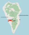
English: Map describing the 2021 Cumbre Vieja volcanic eruption, with location of the volcano shown together with the range of lava coverage (as of 23/11/2021), the capital city, airport and location of centres of destroyed localities of Todoque and La Laguna
Sources:
Polski: Mapa opisująca erupcję wulkanu Cumbre Vieja w 2021 roku, z lokalizacją wulkanu, zasięgiem pokrycia lawą (stan na 23.11.2021), stolicą, lotniskiem oraz zniszczonymi miejscowościami
|
| Date | |
| Source | Own work |
| Author | Jakub Kaczorowski |
Licensing[edit]
I, the copyright holder of this work, hereby publish it under the following license:
This file is licensed under the Creative Commons Attribution-Share Alike 4.0 International license.
- You are free:
- to share – to copy, distribute and transmit the work
- to remix – to adapt the work
- Under the following conditions:
- attribution – You must give appropriate credit, provide a link to the license, and indicate if changes were made. You may do so in any reasonable manner, but not in any way that suggests the licensor endorses you or your use.
- share alike – If you remix, transform, or build upon the material, you must distribute your contributions under the same or compatible license as the original.
File history
Click on a date/time to view the file as it appeared at that time.
| Date/Time | Thumbnail | Dimensions | User | Comment | |
|---|---|---|---|---|---|
| current | 18:24, 24 November 2021 |  | 715 × 937 (596 KB) | Kubek15 (talk | contribs) | updating lava extent |
| 10:56, 18 November 2021 |  | 707 × 933 (592 KB) | Kubek15 (talk | contribs) | remove double scale bar | |
| 10:53, 18 November 2021 |  | 744 × 938 (585 KB) | Kubek15 (talk | contribs) | Updating lava flow as of 12/11/2021 | |
| 21:51, 29 October 2021 |  | 716 × 926 (593 KB) | Kubek15 (talk | contribs) | fixed minor graphic error | |
| 21:49, 29 October 2021 |  | 744 × 938 (595 KB) | Kubek15 (talk | contribs) | Added DEM, improved graphics and updated range of lava field cover | |
| 19:30, 17 October 2021 |  | 543 × 671 (85 KB) | Kubek15 (talk | contribs) | fixed typo | |
| 19:27, 17 October 2021 |  | 535 × 634 (91 KB) | Kubek15 (talk | contribs) | Uploaded own work with UploadWizard |
You cannot overwrite this file.
File usage on Commons
There are no pages that use this file.
File usage on other wikis
The following other wikis use this file:
- Usage on ca.wikipedia.org
- Usage on cs.wikipedia.org
- Usage on de.wikipedia.org
- Usage on en.wikipedia.org
- Usage on eo.wikipedia.org
- Usage on es.wikipedia.org
- Usage on eu.wikipedia.org
- Usage on frr.wikipedia.org
- Usage on is.wikipedia.org
- Usage on pt.wikipedia.org
- Usage on simple.wikipedia.org
- Usage on sl.wikipedia.org
- Usage on th.wikipedia.org
Metadata
This file contains additional information such as Exif metadata which may have been added by the digital camera, scanner, or software program used to create or digitize it. If the file has been modified from its original state, some details such as the timestamp may not fully reflect those of the original file. The timestamp is only as accurate as the clock in the camera, and it may be completely wrong.
| Horizontal resolution | 37.8 dpc |
|---|---|
| Vertical resolution | 37.8 dpc |
| Software used | |
| Date and time of digitizing |
|