File:Map of-Bengal-326-bc-gangaridai.svg

Original file (SVG file, nominally 2,200 × 1,491 pixels, file size: 4.35 MB)
Captions
Captions

Summary[edit]
| Description |
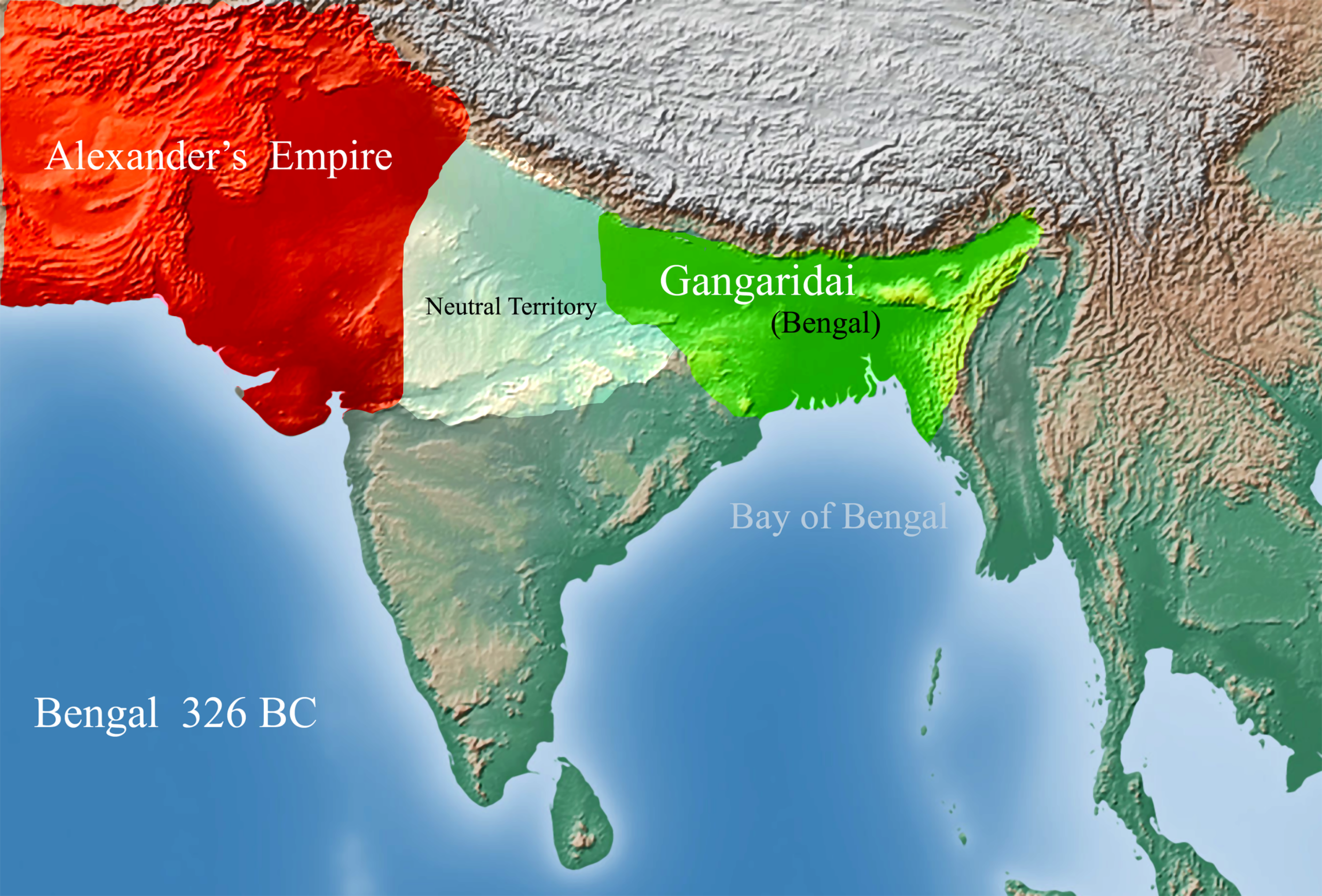
English: This is the Map of Bengal in 326 BC. Gangaridai (Greek: Γανγαρίδαι; Latin: Gangaridae) is a term used by the ancient Greco-Roman writers to describe a people or a geographical entity of the Ganges/Bengal Delta. Their writings describe Alexander the Great withdrew from the Indian subcontinent because of the strong Military force of the Gangaridai present Day Bengal
 Alexander crossed the Indus in 326 BC and fought and won an epic battle against King Porus, who ruled a region lying between the Hydaspes River Punjab, Therefore, Alexander turned south, advancing through southern Punjab and Sindh, along the way conquering more tribes along the lower Indus River. After conquering industry Alexander persuade his soldiers to march farther to Ganges delta to conquer Gangaridai the most prosperous region in South Asia. According to Megasthenes, c. 350 – c. 290 BC) and many Greek scholars Alexander army denied to attack Gangaridai for its geographic defensive position and its Mighty military power.  |
| Date | |
| Source | Own work based on: Ptolemy Asia detail.jpg and Asia vectorial map.jpg |
| Author | Aziz Tarak. |
The Map is based on 11th Map of Asia (Descriptio Undecimae Tabulae Asiae) from Ptolemy's Geography, depicting Gangaridai beyond the Ganges (India extra Gangem) and the land of the Sinai in south-east Asia. Detail observation from the book "Ancient India As Described By Megasthenes And Arrian by Mccrindle & The invasion of India by Alexander the Great as described by Arrian, Q. Curtius, Diodoros, Plutarch and Justin .
Licensing[edit]
- You are free:
- to share – to copy, distribute and transmit the work
- to remix – to adapt the work
- Under the following conditions:
- attribution – You must give appropriate credit, provide a link to the license, and indicate if changes were made. You may do so in any reasonable manner, but not in any way that suggests the licensor endorses you or your use.
File history
Click on a date/time to view the file as it appeared at that time.
| Date/Time | Thumbnail | Dimensions | User | Comment | |
|---|---|---|---|---|---|
| current | 00:08, 17 June 2018 | | 2,200 × 1,491 (4.35 MB) | Aziz Tarak. (talk | contribs) | {{Information |description ={{en|1=This is the Map of Bengal in 326 BC. Gangaridai (Greek: Γανγαρίδαι; Latin: Gangaridae) is a term used by the ancient Greco-Roman writers to describe a people or a geographical entity of the Ganges/Bengal Delta. Their writings describe Alexander the Great withdrew from the Indian subcontinent because of the strong Military force of the Gangaridai present Day Bengal Alexander crossed the Indus in 326 BC and fought and won an epic battle against King Po... |
You cannot overwrite this file.
File usage on Commons
There are no pages that use this file.