File:Map SLH-1650dansk.png
Jump to navigation
Jump to search

Size of this preview: 603 × 600 pixels. Other resolutions: 241 × 240 pixels | 483 × 480 pixels | 900 × 895 pixels.
Original file (900 × 895 pixels, file size: 317 KB, MIME type: image/png)
Captions
Captions
Add a one-line explanation of what this file represents
Summary[edit]
| Description |
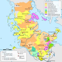
English: Map of Schleswig-Holstein after 1650 (danish version) |
| Date | |
| Source | File:Schleswig-Holstein location map.svg, de:Grafschaft Rantzau, File:Denmark_location_map.svg, http://www.geschichte-s-h.de, Ulrich Lange (Hrsg.): Geschichte Schleswig-Holsteins von den Anfängen bis zur Gegenwart. 2. Auflage 3003, Wachholtz, Neumünster. S.: 133 |
| Author | Begw / MarianneES |
| Other versions |
 |
Licensing[edit]
| I, the copyright holder of this work, release this work into the public domain. This applies worldwide. In some countries this may not be legally possible; if so: I grant anyone the right to use this work for any purpose, without any conditions, unless such conditions are required by law. |
File history
Click on a date/time to view the file as it appeared at that time.
| Date/Time | Thumbnail | Dimensions | User | Comment | |
|---|---|---|---|---|---|
| current | 08:07, 16 February 2010 | | 900 × 895 (317 KB) | MarianneES~commonswiki (talk | contribs) | Category:Maps of Schleswig-Holstein Category:Maps of the history of Denmark |
| 18:23, 15 February 2010 |  | 900 × 895 (317 KB) | MarianneES~commonswiki (talk | contribs) | {{Information |Description={{en|1=Map of Schleswig-Holstein after 1650 (danish version)}} |Source=File:Schleswig-Holstein location map.svg, de:Grafschaft Rantzau, File:Denmark_location_map.svg, [http://www.geschichte-s-h.de/vonabisz/bilder/ |
You cannot overwrite this file.
File usage on Commons
The following page uses this file:
File usage on other wikis
The following other wikis use this file:
- Usage on da.wikipedia.org
- Usage on da.wikibooks.org
- Usage on en.wikipedia.org
- Usage on et.wikipedia.org
- Usage on fi.wikipedia.org
- Usage on no.wikipedia.org
- Usage on ru.wikipedia.org
- Usage on sv.wikipedia.org