File:Map Europe alliances 1914-uk.svg
Jump to navigation
Jump to search

Size of this PNG preview of this SVG file: 800 × 473 pixels. Other resolutions: 320 × 189 pixels | 640 × 379 pixels | 1,024 × 606 pixels | 1,280 × 758 pixels | 2,560 × 1,515 pixels | 1,002 × 593 pixels.
Original file (SVG file, nominally 1,002 × 593 pixels, file size: 73 KB)
Captions
Captions
Add a one-line explanation of what this file represents
Summary[edit]
| Description |
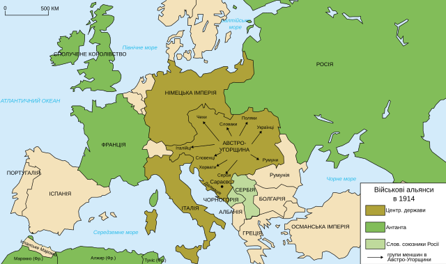
Українська: Схема військових альянсів в Європі в 1914 р. |
| Date | |
| Source | |
| Author |
|
| Other versions |
[]
|
.gif)


| This is a retouched picture, which means that it has been digitally altered from its original version. Modifications: Українська. The original can be viewed here: Map Europe alliances 1914-ru.svg:
|
Licensing[edit]
I, the copyright holder of this work, hereby publish it under the following license:
This file is licensed under the Creative Commons Attribution-Share Alike 2.5 Generic, 2.0 Generic and 1.0 Generic license.
- You are free:
- to share – to copy, distribute and transmit the work
- to remix – to adapt the work
- Under the following conditions:
- attribution – You must give appropriate credit, provide a link to the license, and indicate if changes were made. You may do so in any reasonable manner, but not in any way that suggests the licensor endorses you or your use.
- share alike – If you remix, transform, or build upon the material, you must distribute your contributions under the same or compatible license as the original.
Original upload log[edit]
This image is a derivative work of the following images:
- File:Map_Europe_alliances_1914-ru.svg licensed with Cc-by-sa-2.5,2.0,1.0
- 2010-11-18T08:19:41Z Bronikkk 1002x593 (70461 Bytes) {{Information |Description={{ru|Схема военных альянсов в Европе в 1914 г.}} |Source=*[[:File:Map_Europe_alliances_1914-en.svg|]] |Date=2010-11-18 08:18 (UTC) |Author=*[[:File:Map_Europe_alliances_
Uploaded with derivativeFX
File history
Click on a date/time to view the file as it appeared at that time.
| Date/Time | Thumbnail | Dimensions | User | Comment | |
|---|---|---|---|---|---|
| current | 16:13, 8 June 2017 | | 1,002 × 593 (73 KB) | Viiictorrr (talk | contribs) | Виправив «Османьска, слав (мова про слов’ян)» |
| 21:41, 28 November 2015 |  | 1,002 × 593 (75 KB) | Turnless (talk | contribs) | Russian Islands | |
| 03:12, 9 November 2011 |  | 1,002 × 593 (75 KB) | Homo lupus (talk | contribs) | АВСТРО-УГОРЩИНА | |
| 03:09, 9 November 2011 |  | 1,002 × 593 (75 KB) | Homo lupus (talk | contribs) | == {{int:filedesc}} == {{Information |Description={{uk|Схема військових альянсів в Європі в 1914 р.}} {{ru|Схема военных альянсов в Европе в 1914 г.}} |Source=*[[:File:Map_Europe_alliances_1914- |
You cannot overwrite this file.
File usage on Commons
The following 38 pages use this file:
- User:Magog the Ogre/Maps of conflicts/2015 November
- User:Magog the Ogre/Maps of conflicts/2017 June
- File:1914 ஐரோப்பியக் கூட்டணிகள்.svg
- File:1914년 유럽의 군사동맹지도.PNG
- File:Alliances militaires en Europe 1914-1918-hy.png
- File:Kartenn aliañsoù Europa 1914-br.svg
- File:Map Europe alliances 1914-ar.svg
- File:Map Europe alliances 1914-az.svg
- File:Map Europe alliances 1914-bg.svg
- File:Map Europe alliances 1914-bn.svg
- File:Map Europe alliances 1914-ce.svg
- File:Map Europe alliances 1914-cs.svg
- File:Map Europe alliances 1914-de.svg
- File:Map Europe alliances 1914-el.svg
- File:Map Europe alliances 1914-en.svg
- File:Map Europe alliances 1914-eo.svg
- File:Map Europe alliances 1914-es.svg
- File:Map Europe alliances 1914-fr.svg
- File:Map Europe alliances 1914-gl.svg
- File:Map Europe alliances 1914-he.svg
- File:Map Europe alliances 1914-hr.svg
- File:Map Europe alliances 1914-hu.svg
- File:Map Europe alliances 1914-hy.jpg
- File:Map Europe alliances 1914-it.svg
- File:Map Europe alliances 1914-ko.svg
- File:Map Europe alliances 1914-la.svg
- File:Map Europe alliances 1914-lt.svg
- File:Map Europe alliances 1914-mk.svg
- File:Map Europe alliances 1914-nl.svg
- File:Map Europe alliances 1914-no.svg
- File:Map Europe alliances 1914-ro.svg
- File:Map Europe alliances 1914-sr.svg
- File:Map Europe alliances 1914-sv.svg
- File:Map Europe alliances 1914-ta.png
- File:Map Europe alliances 1914-uk.svg
- File:PotenciasEnLiza1914-pt.svg
- File:PotenciasEnLiza1914.svg
- Template:Other versions/Map Europe alliances 1914
File usage on other wikis
The following other wikis use this file:
- Usage on uk.wikipedia.org
- Usage on www.wikidata.org