File:Mallnitz Stappitz Ankogel-Panorama 01.jpg
Jump to navigation
Jump to search

Size of this preview: 800 × 270 pixels. Other resolutions: 320 × 108 pixels | 640 × 216 pixels | 1,024 × 346 pixels | 1,280 × 432 pixels | 2,560 × 864 pixels | 13,236 × 4,468 pixels.
Original file (13,236 × 4,468 pixels, file size: 44.93 MB, MIME type: image/jpeg)
Captions
Captions
Mallnitz Stappitz Ankogel Austria
| Warning | The original file is very high-resolution. It might not load properly or could cause your browser to freeze when opened at full size. |
|---|
Summary[edit]
| Description |
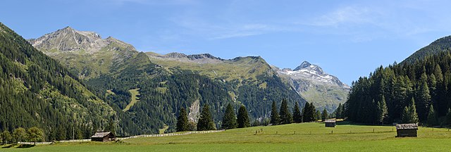
Deutsch: Ankogel (3252 m) im Nationalpark Hohe Tauern – Ansicht von Stappitz im Seebachtal bei Mallnitz, Kärnten, Österreich
English: Ankogel (3,252 metres (10,669 ft)) in the High Tauern National Park – view from Stappitz in the Seebach Valley near Mallnitz, Carinthia, Austria
Čeština: Hora Ankogel (3 252 m n.m.) v pohoří Vysoké Taury v Rakousku, pohled z místa Stappitz v údolí Seebach.
Español: Vista del Ankogel (3252 metros) en el parque nacional Hohe Tauern, desde Stappitz en el valle de Seebach, cerca de Mallnitz, Carintia, Austria.
Magyar: Az Ankogel (3252 m) látképe a Magas-Tauern Nemzeti Parkban a Stappitz felől a Seebach-völgyben (Mallnitz, Karintia, Ausztria)
Македонски: Планината Анкогел (3.252 м) во венецот Високи Таури гледана од долината кај Малниц во Корушка, Австрија.
Эрзянь: Ankogel пандось (3,252 metres (10,669 ft)) Сэрей Тауэрн раськень вирьпусмосо Зеебахской лаймесэ, Каринтия, Австрия.
Português: Montanha Ankogel (3 252 metros) no parque nacional do Alto Tauern, visto do Stappitz no vale de Seebach, perto de Mallnitz, Caríntia, Áustria
|
|||
| Date | ||||
| Source | Own work | |||
| Author | Uoaei1 |

| Camera location | | View this and other nearby images on: OpenStreetMap |
|---|

|
NOTE: This image is a panorama consisting of multiple frames that were merged or stitched in software. As a result, this image necessarily underwent some form of digital manipulation. These manipulations may include blending, blurring, cloning, and colour and perspective adjustments. As a result of these adjustments, the image content may be slightly different from reality at the points where multiple images were combined. This manipulation is often required due to lens, perspective, and parallax distortions.
|
|
The making of this work was supported by Wikimedia Austria. For other files made with the support of Wikimedia Austria, please see the category Supported by Wikimedia Österreich. |
Assessment[edit]
This image was selected as picture of the day on Wikimedia Commons for 14 August 2019. It was captioned as follows: English: Ankogel (3,252 metres (10,669 ft)) in the High Tauern National Park – view from Stappitz in the Seebach Valley near Mallnitz, Carinthia, Austria Other languages:
Čeština: Hora Ankogel (3 252 m n.m.) v pohoří Vysoké Taury v Rakousku, pohled z místa Stappitz v údolí Seebach. Deutsch: Ankogel (3252 m) im Nationalpark Hohe Tauern – Ansicht von Stappitz im Seebachtal bei Mallnitz, Kärnten, Österreich English: Ankogel (3,252 metres (10,669 ft)) in the High Tauern National Park – view from Stappitz in the Seebach Valley near Mallnitz, Carinthia, Austria Español: Vista del Ankogel (3252 metros) en el parque nacional Hohe Tauern, desde Stappitz en el valle de Seebach, cerca de Mallnitz, Carintia, Austria. Magyar: Az Ankogel (3252 m) látképe a Magas-Tauern Nemzeti Parkban a Stappitz felől a Seebach-völgyben (Mallnitz, Karintia, Ausztria) Português: Montanha Ankogel (3 252 metros) no parque nacional do Alto Tauern, visto do Stappitz no vale de Seebach, perto de Mallnitz, Caríntia, Áustria Македонски: Планината Анкогел (3.252 м) во венецот Високи Таури гледана од долината кај Малниц во Корушка, Австрија. |
|
This image has been assessed using the Quality image guidelines and is considered a Quality image.
|
Licensing[edit]
I, the copyright holder of this work, hereby publish it under the following license:
This file is licensed under the Creative Commons Attribution-Share Alike 4.0 International license.
- You are free:
- to share – to copy, distribute and transmit the work
- to remix – to adapt the work
- Under the following conditions:
- attribution – You must give appropriate credit, provide a link to the license, and indicate if changes were made. You may do so in any reasonable manner, but not in any way that suggests the licensor endorses you or your use.
- share alike – If you remix, transform, or build upon the material, you must distribute your contributions under the same or compatible license as the original.

|
Diese Datei wurde im Rahmen von WikiDaheim 2017 in Österreich erstellt und hochgeladen. Sie wurde dem Themenbereich Naturschutz zugeordnet. |
| Annotations | This image is annotated: View the annotations at Commons |
File history
Click on a date/time to view the file as it appeared at that time.
| Date/Time | Thumbnail | Dimensions | User | Comment | |
|---|---|---|---|---|---|
| current | 08:22, 15 August 2017 | 13,236 × 4,468 (44.93 MB) | Uoaei1 (talk | contribs) | User created page with UploadWizard |
You cannot overwrite this file.
File usage on Commons
The following 29 pages use this file:
- Ankogel
- Mallnitz
- WikiDaheim Vorjury 2017
- User:Anton-kurt/Tyrol new files/2017 August 11-20
- User talk:Uoaei1/Archive07
- Commons:Featured picture candidates/File:Mallnitz Stappitz Ankogel-Panorama 01.jpg
- Commons:Featured picture candidates/Log/September 2017
- Commons:Featured pictures/Places/Natural/Austria
- Commons:Featured pictures/chronological/2017-B
- Commons:Picture of the Year/2017/Candidates
- Commons:Picture of the Year/2017/R1/Gallery/2017-B
- Commons:Picture of the Year/2017/R1/Gallery/ALL
- Commons:Picture of the Year/2017/R1/Gallery/M09
- Commons:Picture of the Year/2017/R1/Gallery/Panoramic views
- Commons:Picture of the Year/2017/R1/v/Mallnitz Stappitz Ankogel-Panorama 01.jpg
- Commons:Quality images/Subject/Places/Natural structures/Panorama/Archive 2017
- Commons:Quality images candidates/Archives August 18 2017
- Template:Potd/2019-08
- Template:Potd/2019-08-14
- Template:Potd/2019-08-14 (cs)
- Template:Potd/2019-08-14 (de)
- Template:Potd/2019-08-14 (en)
- Template:Potd/2019-08-14 (es)
- Template:Potd/2019-08-14 (hu)
- Template:Potd/2019-08-14 (mk)
- Template:Potd/2019-08-14 (myv)
- Template:Potd/2019-08-14 (nl)
- Template:Potd/2019-08-14 (pt)
- Template:Potd/2019-08-14 (pt-br)
File usage on other wikis
The following other wikis use this file:
- Usage on be-tarask.wikipedia.org
- Usage on bn.wikipedia.org
- Usage on crh.wikipedia.org
- Usage on cv.wikipedia.org
- Usage on de.wikipedia.org
- Usage on en.wikipedia.org
- Usage on fr.wikipedia.org
- Usage on hu.wikipedia.org
- Usage on hy.wikipedia.org
- Usage on ka.wikipedia.org
- Usage on ko.wikipedia.org
- Usage on lbe.wikipedia.org
- Usage on lez.wikipedia.org
- Usage on mk.wikipedia.org
- Usage on os.wikipedia.org
- Usage on pfl.wikipedia.org
- Usage on pt.wikipedia.org
- Usage on ru.wikipedia.org
- Usage on ru.wikinews.org
- Usage on sah.wikipedia.org
- Usage on sq.wikipedia.org
- Usage on tt.wikipedia.org
- Usage on uk.wikipedia.org
- Usage on vep.wikipedia.org
- Usage on zh.wikipedia.org