File:Mali Azawad rebellion fr.svg
Jump to navigation
Jump to search

Size of this PNG preview of this SVG file: 629 × 600 pixels. Other resolutions: 252 × 240 pixels | 503 × 480 pixels | 805 × 768 pixels | 1,074 × 1,024 pixels | 2,148 × 2,048 pixels | 1,315 × 1,254 pixels.
Original file (SVG file, nominally 1,315 × 1,254 pixels, file size: 726 KB)
Captions
Captions
Add a one-line explanation of what this file represents
Summary[edit]
| Description |
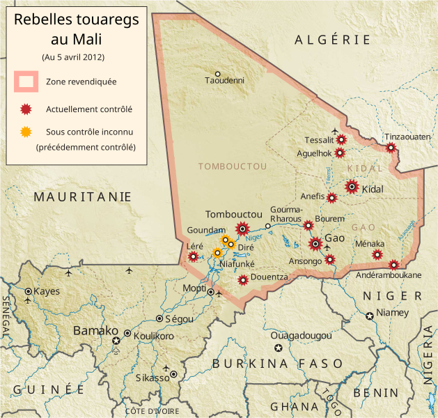
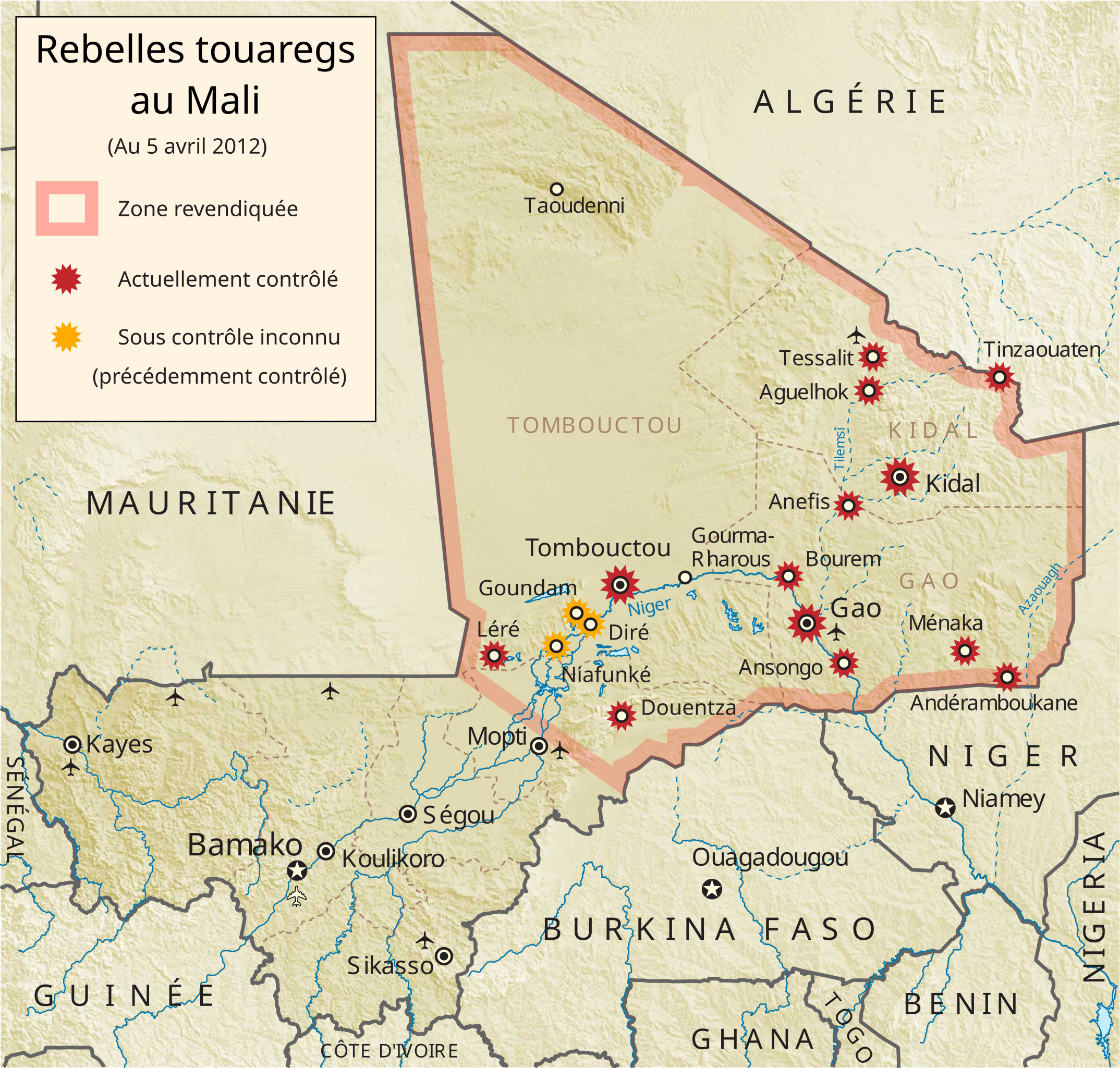
English: Map of the Tuareg rebellion in Azawad, Northern Mali showing rebel attacks as of 5 April 2012. (French)
Français : Carte du rébellion touareg au Azawad, au nord de Mali indiquant attaques des rebelles au 5 avril 2012 (Français) |
| Source |
Own work based on File:Azawad Tuareg rebellion 2012.svg This vector image includes elements that have been taken or adapted from this file: This vector image includes elements that have been taken or adapted from this file: |
| Author | Orionist (original design), GeoEvan (modifications, updates), WhisperToMe (translation) |
| Other versions | File:Azawad Tuareg rebellion 2012.svg (English/Anglais), Macedonian/македонски јазик/Macédonien |
Licensing[edit]
This file is licensed under the Creative Commons Attribution-Share Alike 3.0 Unported license.
- You are free:
- to share – to copy, distribute and transmit the work
- to remix – to adapt the work
- Under the following conditions:
- attribution – You must give appropriate credit, provide a link to the license, and indicate if changes were made. You may do so in any reasonable manner, but not in any way that suggests the licensor endorses you or your use.
- share alike – If you remix, transform, or build upon the material, you must distribute your contributions under the same or compatible license as the original.
File history
Click on a date/time to view the file as it appeared at that time.
| Date/Time | Thumbnail | Dimensions | User | Comment | |
|---|---|---|---|---|---|
| current | 12:22, 9 April 2012 | | 1,315 × 1,254 (726 KB) | GeoEvan (talk | contribs) | One more adjustment |
| 12:20, 9 April 2012 |  | 1,315 × 1,254 (726 KB) | GeoEvan (talk | contribs) | Adjusting text layout after seeing Wikipedia's PNG rendering | |
| 12:13, 9 April 2012 |  | 1,315 × 1,254 (726 KB) | GeoEvan (talk | contribs) | Fixing and improving wording, per ref desk feedback [http://en.wikipedia.org/wiki/Wikipedia:Reference_desk/Language#French_help:_.22Unknown_control.22] | |
| 16:45, 5 April 2012 |  | 1,315 × 1,254 (726 KB) | GeoEvan (talk | contribs) | {{Information |Description ={{fr|1=Carte du rébellion touareg au Azawad, au nord de Mali indiquant attaques des rebelles au 5 avril 2012}} |Source ={{own}} based on File:Azawad Tuareg rebellion 2012.svg {{AttribSVG|Mali relief location... |
You cannot overwrite this file.
File usage on Commons
There are no pages that use this file.
File usage on other wikis
The following other wikis use this file:
- Usage on fr.wikipedia.org
- Usage on fr.wikinews.org
- États-Unis : Audition au Sénat sur la situation au Mali
- Mali : La CEDEAO met la pression sur l'ONU
- Mali : Chronologie des évènements en 2012
- Mali : l'ONU donne son feu vert au déploiement d'une force internationale
- Mali : les islamistes se rapprochent de la ligne de front
- Mali : Hollande confirme l'engagement de l'armée française
- Mali : état d’urgence déclaré
- Mali: forces françaises et maliennes prennent une nouvelle ville
- Usage on nl.wikipedia.org
- Usage on no.wikipedia.org
- Usage on www.wikidata.org