File:Malawi regions.svg
Jump to navigation
Jump to search

Size of this PNG preview of this SVG file: 424 × 600 pixels. Other resolutions: 170 × 240 pixels | 339 × 480 pixels | 543 × 768 pixels | 724 × 1,024 pixels | 1,448 × 2,048 pixels | 744 × 1,052 pixels.
Original file (SVG file, nominally 744 × 1,052 pixels, file size: 1.08 MB)
Captions
Captions
Add a one-line explanation of what this file represents
Summary[edit]
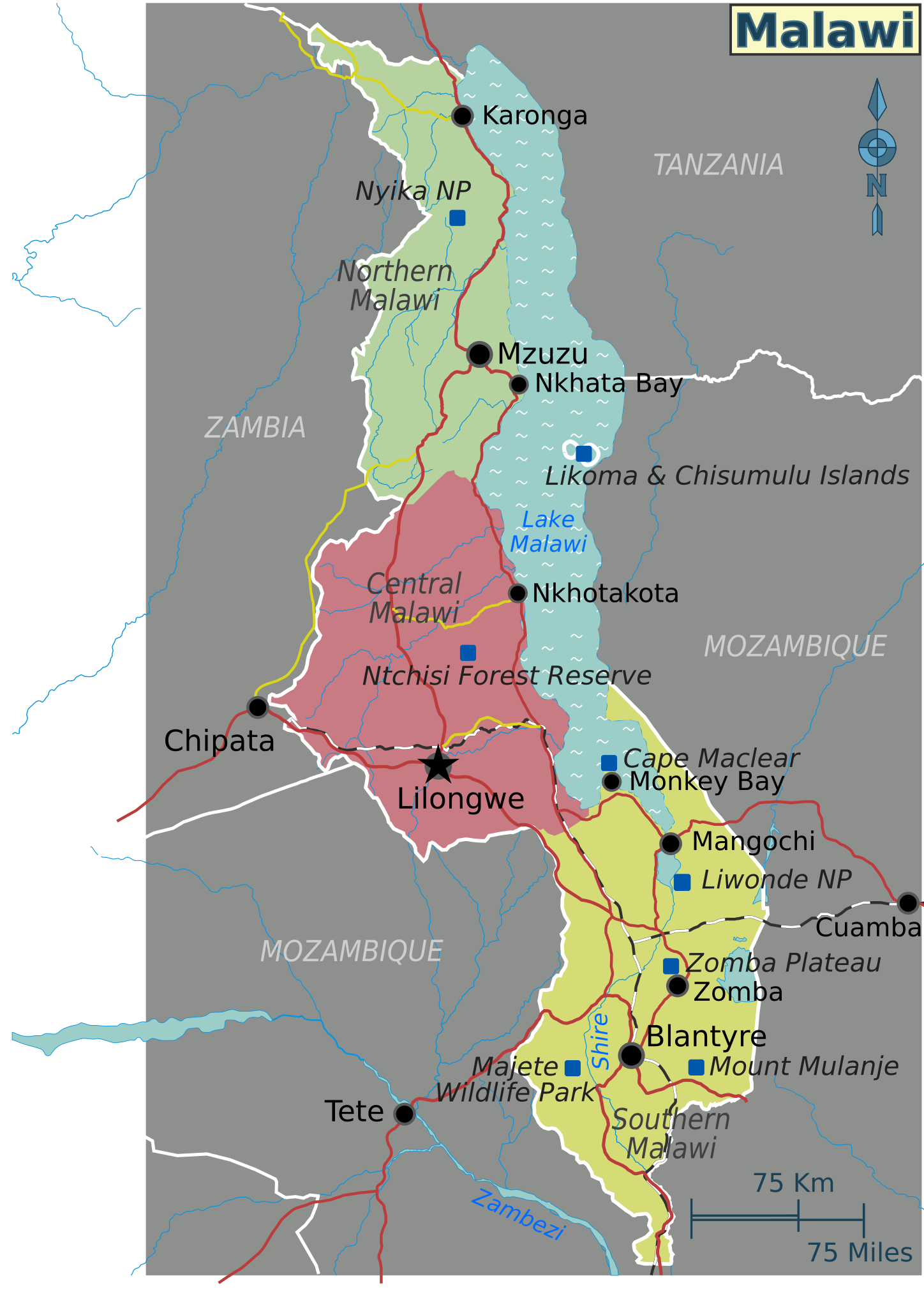
| Description | Map of Malawi with regions, major cities and other destinations noted (for use on Wikivoyage), multilingual SVG file | ||||
| Date | |||||
| Source |
Own work based on the UN map of Malawi
|
||||
| Author | Shaund | ||||
| Other versions |
PNG files: |
Licensing[edit]
This file is licensed under the Creative Commons Attribution-Share Alike 4.0 International, 3.0 Unported, 2.5 Generic, 2.0 Generic and 1.0 Generic license.
- You are free:
- to share – to copy, distribute and transmit the work
- to remix – to adapt the work
- Under the following conditions:
- attribution – You must give appropriate credit, provide a link to the license, and indicate if changes were made. You may do so in any reasonable manner, but not in any way that suggests the licensor endorses you or your use.
- share alike – If you remix, transform, or build upon the material, you must distribute your contributions under the same or compatible license as the original.
Original upload log[edit]
| This file was imported from Wikivoyage WTS. |
The original description page was here. All following user names refer to wts.wikivoyage-old.
- 2010-02-01 05:41 (WT-shared) Shaund archive copy at the Wayback Machine 744×1052 (1133708 bytes) {{Imagecredit|credit=[[User:Shaund|Shaund]]|captureDate=31 Jan 2010|location=Malawi|source=Drawn by me based on map from [http://www.un.org/ (Import from wikitravel.org/shared)
File history
Click on a date/time to view the file as it appeared at that time.
| Date/Time | Thumbnail | Dimensions | User | Comment | |
|---|---|---|---|---|---|
| current | 00:45, 18 November 2012 | | 744 × 1,052 (1.08 MB) | MGA73bot2 (talk | contribs) | {{BotMoveToCommons|wts.oldwikivoyage|year={{subst:CURRENTYEAR}}|month={{subst:CURRENTMONTHNAME}}|day={{subst:CURRENTDAY}}}} == {{int:filedesc}} == {{Information |description=Map of Malawi. SVG base map for Malawi regions, Malawi * Map of: Malawi¤ |dat... |
You cannot overwrite this file.
File usage on Commons
There are no pages that use this file.
File usage on other wikis
The following other wikis use this file:
- Usage on ca.wikipedia.org
- Usage on en.wikipedia.org
- Usage on zh.wikipedia.org