File:MalawiOMC.png
Jump to navigation
Jump to search

Size of this preview: 288 × 598 pixels. Other resolutions: 115 × 240 pixels | 500 × 1,039 pixels.
Original file (500 × 1,039 pixels, file size: 31 KB, MIME type: image/png)
Captions
Captions
Add a one-line explanation of what this file represents
Summary
[edit]
| Description | |
| Date | 9 August 2007 (original upload date) |
| Source | This map's source is here, with the uploader's (User:Kelisi) modifications. |
| Author | |
| Permission (Reusing this file) |
Original uploader used GFDL; added CC-by-2.5 as per the licensing of the original source map noted above. |
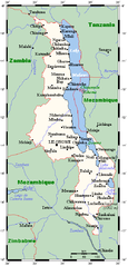
A map showing Malawi sand main towns. This map's source is here, with the uploader's modifications, and the GMT homepage archive copy at the Wayback Machine says that the tools are released under the GNU General Public License.
Licensing
[edit]

|
Permission is granted to copy, distribute and/or modify this document under the terms of the GNU Free Documentation License, Version 1.2 or any later version published by the Free Software Foundation; with no Invariant Sections, no Front-Cover Texts, and no Back-Cover Texts. A copy of the license is included in the section entitled GNU Free Documentation License. |
| This file is licensed under the Creative Commons Attribution-Share Alike 3.0 Unported license. | ||
| ||
| This licensing tag was added to this file as part of the GFDL licensing update. |
This file is licensed under the Creative Commons Attribution 2.5 Generic license.
- You are free:
- to share – to copy, distribute and transmit the work
- to remix – to adapt the work
- Under the following conditions:
- attribution – You must give appropriate credit, provide a link to the license, and indicate if changes were made. You may do so in any reasonable manner, but not in any way that suggests the licensor endorses you or your use.
Original upload log
[edit]
The original description page was here. All following user names refer to en.wikipedia.
Transferred to Commons using FtCG.
| Date/Time | Dimensions | User | Comment |
|---|---|---|---|
| 16:42, 9 August 2007 | 500 × 1,039 (32,038 bytes) | w:en:Kelisi (talk | contribs) | (== Summary == A map showing Malawi's cities and main towns. This map's source is [http://www.aquarius.ifm-geomar.de/ here], with the uploader's modifications, and the [http://gmt.soest.hawaii.edu/ GMT homepage] says that the tools are released under the G) |
File history
Click on a date/time to view the file as it appeared at that time.
| Date/Time | Thumbnail | Dimensions | User | Comment | |
|---|---|---|---|---|---|
| current | 18:56, 28 April 2012 | | 500 × 1,039 (31 KB) | Darkwind (talk | contribs) | Transferred from en.wikipedia: see original upload log above |
You cannot overwrite this file.
File usage on Commons
There are no pages that use this file.
File usage on other wikis
The following other wikis use this file:
- Usage on ar.wikipedia.org
- Usage on ca.wikipedia.org
- Usage on en.wikipedia.org
- Usage on ha.wikipedia.org
- Usage on ig.wikipedia.org
- Usage on tum.wikipedia.org
- Usage on uk.wikipedia.org