File:Mainmuendung Luftbild.jpg
Jump to navigation
Jump to search

Size of this preview: 800 × 600 pixels. Other resolutions: 320 × 240 pixels | 640 × 480 pixels | 1,024 × 768 pixels | 1,280 × 960 pixels | 2,560 × 1,920 pixels | 3,648 × 2,736 pixels.
Original file (3,648 × 2,736 pixels, file size: 1.69 MB, MIME type: image/jpeg)
Captions
Captions
Add a one-line explanation of what this file represents
Summary[edit]
| Description |
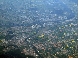
English: aerial view of the Main river flowing (upward) into the Rhine (flowing from left to right)
Deutsch: Luftbild der Mündung des Mains (Fließrichtung: aufwärts) in der Rhein (fließt von links nach rechts). Zu sehen sind vorne am linken Mainufer Raunheim, dann Rüsselsheim mit den Opelwerken, dahinter jenseits der Bahnanlagen Bischofsheim und in der Mainspitze Gustavsburg. Rheinaufwärts liegt Ginsheim. Am rechten Mainufer vorne liegt Flörsheim, weiter flussabwärts Hochheim mit den Weinbergen. Dann folgen die Wiesbadener Stadtteile Mainz-Kostheim und Mainz-Kastel. Ihnen gegenüber auf der linken Rheinseite liegt Mainz. Am rechen Bildrand in der Flussbiegung liegen Wiesbaden-Biebrich und Wiesbaden-Schierstein. Dahinter sind noch Teile des Rheingaus erkennbar. |
| Date | |
| Source | Own work |
| Author | Toksave |
Licensing[edit]
I, the copyright holder of this work, hereby publish it under the following licenses:
This file is licensed under the Creative Commons Attribution-Share Alike 3.0 Unported license.
- You are free:
- to share – to copy, distribute and transmit the work
- to remix – to adapt the work
- Under the following conditions:
- attribution – You must give appropriate credit, provide a link to the license, and indicate if changes were made. You may do so in any reasonable manner, but not in any way that suggests the licensor endorses you or your use.
- share alike – If you remix, transform, or build upon the material, you must distribute your contributions under the same or compatible license as the original.

|
Permission is granted to copy, distribute and/or modify this document under the terms of the GNU Free Documentation License, Version 1.2 or any later version published by the Free Software Foundation; with no Invariant Sections, no Front-Cover Texts, and no Back-Cover Texts. A copy of the license is included in the section entitled GNU Free Documentation License. |
You may select the license of your choice.
File history
Click on a date/time to view the file as it appeared at that time.
| Date/Time | Thumbnail | Dimensions | User | Comment | |
|---|---|---|---|---|---|
| current | 20:04, 13 May 2008 | | 3,648 × 2,736 (1.69 MB) | Toksave (talk | contribs) | {{Information |Description=en:aerial view of the Main river flowing into the Rhine de: Luftbild der Mündung des Mains in der Rhein: vorne links ist Rüsselsheim, auf der anderen Rheinseite Mainz und ganz rechts sind Teile Wiesbadens zu sehen. |Source=se |
You cannot overwrite this file.
File usage on Commons
The following 2 pages use this file:
File usage on other wikis
The following other wikis use this file:
- Usage on azb.wikipedia.org
- Usage on de.wikipedia.org
- Usage on fi.wikipedia.org
- Usage on lb.wikipedia.org
- Usage on nl.wikipedia.org
- Usage on uk.wikipedia.org
Metadata
Categories:
- Rhine in Mainz in 2008
- Rhine in Hesse in 2008
- Main in Hesse in 2008
- Aerial photographs of Hochheim am Main
- Aerial photographs of Flörsheim am Main
- Main in Rüsselsheim
- Mainspitze
- Aerial photographs of Kreis Groß-Gerau
- Aerial photographs of Mainz
- 2008 in Mainz
- Aerial photographs of confluences
- Main in Main-Taunus-Kreis