File:Main maritime shipping routes.png
Jump to navigation
Jump to search

Size of this preview: 756 × 600 pixels. Other resolutions: 303 × 240 pixels | 605 × 480 pixels | 968 × 768 pixels | 1,220 × 968 pixels.
Original file (1,220 × 968 pixels, file size: 808 KB, MIME type: image/png)
Captions
Captions
Main maritime shipping routes
Summary[edit]
| Description |
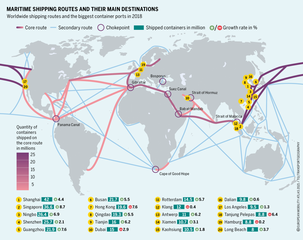
English: Main maritime shipping routes, chokepoints and biggest container ports in 2018. |
| Date | |
| Source | https://eu.boell.org/sites/default/files/2021-02/EUMobilityatlas2021_FINAL_WEB.pdf?dimension1=euma2021 |
| Author | Heinrich-Böll-Stiftung European Union |
Licensing[edit]
This file is licensed under the Creative Commons Attribution-Share Alike 4.0 International license.
- You are free:
- to share – to copy, distribute and transmit the work
- to remix – to adapt the work
- Under the following conditions:
- attribution – You must give appropriate credit, provide a link to the license, and indicate if changes were made. You may do so in any reasonable manner, but not in any way that suggests the licensor endorses you or your use.
- share alike – If you remix, transform, or build upon the material, you must distribute your contributions under the same or compatible license as the original.
File history
Click on a date/time to view the file as it appeared at that time.
| Date/Time | Thumbnail | Dimensions | User | Comment | |
|---|---|---|---|---|---|
| current | 14:11, 24 May 2022 | | 1,220 × 968 (808 KB) | WikipSQ (talk | contribs) | Uploaded a work by Heinrich-Böll-Stiftung European Union from https://eu.boell.org/en/shipping-setting-sail-challenges-for-sea-transport with UploadWizard |
You cannot overwrite this file.
File usage on Commons
There are no pages that use this file.
File usage on other wikis
The following other wikis use this file:
- Usage on fr.wikipedia.org