File:Maidenhead Locator Map.png
Jump to navigation
Jump to search

Size of this preview: 800 × 400 pixels. Other resolutions: 320 × 160 pixels | 640 × 320 pixels | 1,024 × 512 pixels | 1,280 × 640 pixels | 3,600 × 1,800 pixels.
Original file (3,600 × 1,800 pixels, file size: 925 KB, MIME type: image/png)
Captions
Captions
Add a one-line explanation of what this file represents
Summary[edit]
| Description |
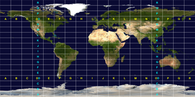
English: A map of the world subdivided into fields used in the Maidenhead Locator System used by Amateur radio operators. Each individual field is 10° in latitude and 20° in longitude.
This image was constructed from a public domain Visible Earth product of the Earth Observatory office of the United States government space agency NASA. It is based on a cylindrical equi-distant projection, and was manually marked up by User:Denelson83. |
| Source | http://visibleearth.nasa.gov/view_rec.php?id=2433 |
| Author | User:Denelson83 |
Licensing[edit]
| This file is in the public domain in the United States because it was solely created by NASA. NASA copyright policy states that "NASA material is not protected by copyright unless noted". (See Template:PD-USGov, NASA copyright policy page or JPL Image Use Policy.) | ||
 |
Warnings:
|
File history
Click on a date/time to view the file as it appeared at that time.
| Date/Time | Thumbnail | Dimensions | User | Comment | |
|---|---|---|---|---|---|
| current | 07:25, 12 October 2010 | | 3,600 × 1,800 (925 KB) | Denelson83 (talk | contribs) | Thicken the field grid lines |
| 07:12, 12 October 2010 |  | 3,600 × 1,800 (946 KB) | Denelson83 (talk | contribs) | {{Information |Description={{en|1=A map of the world subdivided into fields used in the w:Maidenhead Locator System used by w:Amateur radio operators. Each individual field is 10° in latitude and 20° in longitude. This image was constructed |
You cannot overwrite this file.
File usage on Commons
The following page uses this file:
File usage on other wikis
The following other wikis use this file:
- Usage on de.wikipedia.org
- Usage on en.wikipedia.org
- Usage on pl.wikipedia.org
- Usage on pt.wikipedia.org
- Usage on ru.wikipedia.org
- Usage on th.wikipedia.org
- Usage on uk.wikipedia.org
- Usage on www.wikidata.org
- Usage on zh.wikipedia.org