File:Mackenzie River Outflow.jpg
Jump to navigation
Jump to search

Size of this preview: 670 × 599 pixels. Other resolutions: 268 × 240 pixels | 537 × 480 pixels | 858 × 768 pixels | 1,145 × 1,024 pixels | 2,289 × 2,048 pixels | 7,600 × 6,800 pixels.
Original file (7,600 × 6,800 pixels, file size: 91.24 MB, MIME type: image/jpeg)
Captions
Captions
Add a one-line explanation of what this file represents
Summary[edit]
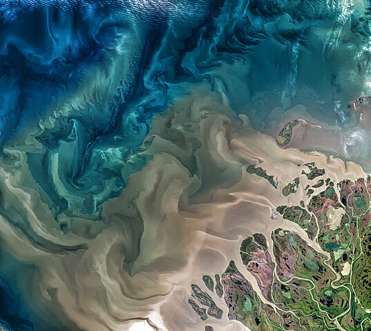
| Description | The above image shows part of the Mackenzie River delta and the river's turbid waters flowing into the Beaufort Sea. The Mackenzie River in Canada plays a major role in Arctic climate as warmer fresh water mixes with cold seawater. |
| Date | |
| Source | https://oceancolor.gsfc.nasa.gov/gallery/541/ |
| Author | Operational Land Imager on the Landsat 8 satellite |
| Warning | The original file is very high-resolution. It might not load properly or could cause your browser to freeze when opened at full size. |
|---|
Assessment[edit]
|
Licensing[edit]
| This file is in the public domain in the United States because it was solely created by NASA. NASA copyright policy states that "NASA material is not protected by copyright unless noted". (See Template:PD-USGov, NASA copyright policy page or JPL Image Use Policy.) | ||
 |
Warnings:
|
File history
Click on a date/time to view the file as it appeared at that time.
| Date/Time | Thumbnail | Dimensions | User | Comment | |
|---|---|---|---|---|---|
| current | 09:35, 7 June 2021 | | 7,600 × 6,800 (91.24 MB) | StellarHalo (talk | contribs) | higher resolution |
| 07:34, 7 January 2021 |  | 1,920 × 1,718 (2.89 MB) | StellarHalo (talk | contribs) | {{Information |Description=The Mackenzie River in Canada plays a major role in Arctic climate as warmer fresh water mixes with cold seawater. |Source=https://climate.nasa.gov/climate_resources/158/mackenzie-river/ |Date=July 18, 2017. |Author=Operational Land Imager on the Landsat 8 satellite |Permission= |other_versions= }} Category:Satellite pictures of the Northwest Territories |
You cannot overwrite this file.
File usage on Commons
The following 17 pages use this file:
- User:Aconcagua/Alaska new/2021 January
- User:Aconcagua/Alaska new/2021 June
- User talk:StellarHalo
- Commons:Featured picture candidates/File:Mackenzie River.jpg
- Commons:Featured picture candidates/File:Mackenzie River Outflow.jpg
- Commons:Featured picture candidates/Log/April 2021
- Commons:Featured picture candidates/Log/November 2021
- Commons:Featured pictures/Places/Satellite images
- Commons:Featured pictures/chronological/2021-B
- Commons:Featured pictures/chronological/November 2021
- Commons:Picture of the Year/2021/Candidates
- Commons:Picture of the Year/2021/R1/Gallery/2021-B
- Commons:Picture of the Year/2021/R1/Gallery/ALL
- Commons:Picture of the Year/2021/R1/Gallery/Astronomy
- Commons:Picture of the Year/2021/R1/Gallery/M11
- Commons:Picture of the Year/2021/R1/v/Mackenzie River Outflow.jpg
- File:Mackenzie River.jpg (file redirect)
File usage on other wikis
The following other wikis use this file:
- Usage on fr.wikipedia.org