File:Maasi valgala-es.svg
Jump to navigation
Jump to search

Size of this PNG preview of this SVG file: 396 × 600 pixels. Other resolutions: 158 × 240 pixels | 317 × 480 pixels | 507 × 768 pixels | 676 × 1,024 pixels | 1,352 × 2,048 pixels | 660 × 1,000 pixels.
Original file (SVG file, nominally 660 × 1,000 pixels, file size: 452 KB)
Captions
Captions
Add a one-line explanation of what this file represents
Summary[edit]
| Description |
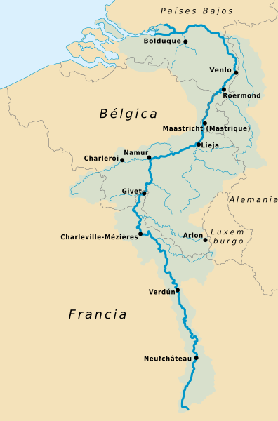
Français : Carte représentant l'importance du Bassin de la Meuse en Wallonie |
| Date | |
| Source | Own work based on: Bassin de la Meuse.svg by Nicolas Lardot and Maasi valgala.svg by Ahsoous |
| Author | Rowanwindwhistler |
| SVG development |
Licensing[edit]
This file is licensed under the Creative Commons Attribution-Share Alike 4.0 International license.
- You are free:
- to share – to copy, distribute and transmit the work
- to remix – to adapt the work
- Under the following conditions:
- attribution – You must give appropriate credit, provide a link to the license, and indicate if changes were made. You may do so in any reasonable manner, but not in any way that suggests the licensor endorses you or your use.
- share alike – If you remix, transform, or build upon the material, you must distribute your contributions under the same or compatible license as the original.
File history
Click on a date/time to view the file as it appeared at that time.
| Date/Time | Thumbnail | Dimensions | User | Comment | |
|---|---|---|---|---|---|
| current | 09:38, 16 August 2020 | | 660 × 1,000 (452 KB) | Rowanwindwhistler (talk | contribs) | Fake text added, larger font |
| 15:31, 25 July 2020 |  | 660 × 1,000 (226 KB) | Mapeh (talk | contribs) | Error Aquisgrán | |
| 14:23, 11 June 2020 |  | 660 × 1,000 (227 KB) | Mapeh (talk | contribs) | New version, translated from latest French version | |
| 09:07, 18 March 2017 |  | 704 × 1,067 (439 KB) | Rowanwindwhistler (talk | contribs) | User created page with UploadWizard |
You cannot overwrite this file.
File usage on Commons
The following 10 pages use this file:
- User:Chumwa/OgreBot/Potential transport maps/2017 March 11-20
- User:Chumwa/OgreBot/Transport Maps/2017 March 11-20
- User:Chumwa/OgreBot/Transport Maps/2020 August 11-20
- User:Chumwa/OgreBot/Transport Maps/2020 July 21-31
- User:Chumwa/OgreBot/Transport Maps/2020 June 11-20
- User:Chumwa/OgreBot/Travel and communication maps/2017 March 11-20
- User:Magog the Ogre/Multilingual legend/2020 August 11-20
- User:Magog the Ogre/Multilingual legend/2020 July 21-31
- User:Magog the Ogre/Multilingual legend/2020 June 11-20
- User:Mapeh