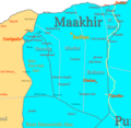
File:Maakhir map.png
From Wikimedia Commons, the free media repository
Jump to navigation
Jump to search
Maakhir_map.png (476 × 466 pixels, file size: 75 KB, MIME type: image/png)
File information
Structured data
Captions
Captions
Add a one-line explanation of what this file represents
Summary
[edit]| DescriptionMaakhir map.png | Map of Maakhir State of Somalia |
| Date | |
| Source | Own work |
| Author | Ingoman |
Licensing
[edit]| Public domainPublic domainfalsefalse |
| I, the copyright holder of this work, release this work into the public domain. This applies worldwide. In some countries this may not be legally possible; if so: I grant anyone the right to use this work for any purpose, without any conditions, unless such conditions are required by law. |
File history
Click on a date/time to view the file as it appeared at that time.
| Date/Time | Thumbnail | Dimensions | User | Comment | |
|---|---|---|---|---|---|
| current | 22:20, 17 March 2023 |  | 476 × 466 (75 KB) | Ayakatalintaguri3 (talk | contribs) | . |
| 19:05, 27 February 2008 |  | 476 × 466 (28 KB) | Ingoman (talk | contribs) | ||
| 17:23, 14 December 2007 |  | 487 × 571 (29 KB) | Ingoman (talk | contribs) | ||
| 21:40, 27 October 2007 |  | 544 × 624 (42 KB) | Ingoman (talk | contribs) | ||
| 01:56, 25 October 2007 |  | 540 × 584 (37 KB) | Ingoman (talk | contribs) | ||
| 03:25, 23 October 2007 |  | 676 × 768 (40 KB) | Ingoman (talk | contribs) | Reverted to version as of 03:09, 2 October 2007 | |
| 07:40, 22 October 2007 |  | 532 × 620 (36 KB) | Ingoman (talk | contribs) | ||
| 03:09, 2 October 2007 |  | 676 × 768 (40 KB) | Ingoman (talk | contribs) | {{Information |Description=Map of Maakhir State of Somalia |Source=self-made |Date=October 1st 2007 |Author= Ingoman }} |
You cannot overwrite this file.
File usage on Commons
The following 2 pages use this file:
File usage on other wikis
The following other wikis use this file:
- Usage on azb.wikipedia.org
- Usage on ca.wikipedia.org
- Usage on de.wikipedia.org
- Usage on eo.wikipedia.org
- Usage on es.wikipedia.org
- Usage on fr.wikipedia.org
- Usage on it.wikipedia.org
- Usage on pt.wikipedia.org
- Usage on ru.wikipedia.org
- Usage on uk.wikipedia.org
Metadata
This file contains additional information such as Exif metadata which may have been added by the digital camera, scanner, or software program used to create or digitize it. If the file has been modified from its original state, some details such as the timestamp may not fully reflect those of the original file. The timestamp is only as accurate as the clock in the camera, and it may be completely wrong.
| Horizontal resolution | 47.24 dpc |
|---|---|
| Vertical resolution | 47.24 dpc |
| Software used |
Hidden categories:
