File:MSY flight map.svg
Jump to navigation
Jump to search

Size of this PNG preview of this SVG file: 800 × 417 pixels. Other resolutions: 320 × 167 pixels | 640 × 333 pixels | 1,024 × 533 pixels | 1,280 × 667 pixels | 2,560 × 1,333 pixels | 1,859 × 968 pixels.
Original file (SVG file, nominally 1,859 × 968 pixels, file size: 752 KB)
Captions
Captions
Add a one-line explanation of what this file represents
Summary[edit]
| Description |
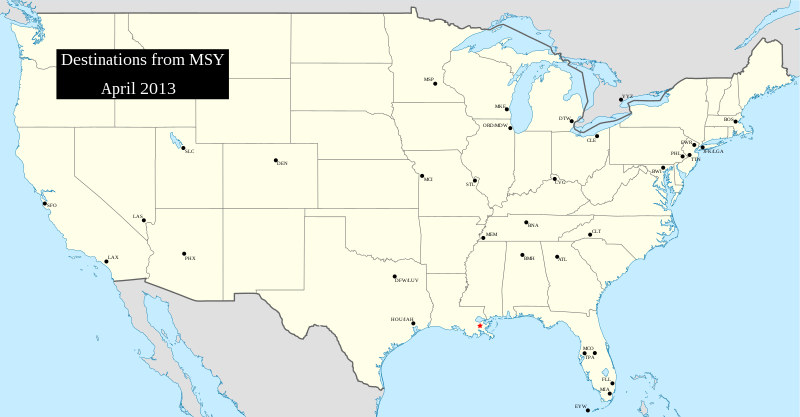
English: Map showing the destinations of outbound flights from Louis Armstrong New Orleans International Airport |
| Date | (UTC) |
| Source |
This file was derived from: USA location map.svg: |
| Author |
|
| This is a retouched picture, which means that it has been digitally altered from its original version. Modifications: Added text and shapes. The original can be viewed here: USA location map.svg:
|
Licensing[edit]
I, the copyright holder of this work, hereby publish it under the following licenses:
This file is licensed under the Creative Commons Attribution-Share Alike 3.0 Unported license.
- You are free:
- to share – to copy, distribute and transmit the work
- to remix – to adapt the work
- Under the following conditions:
- attribution – You must give appropriate credit, provide a link to the license, and indicate if changes were made. You may do so in any reasonable manner, but not in any way that suggests the licensor endorses you or your use.
- share alike – If you remix, transform, or build upon the material, you must distribute your contributions under the same or compatible license as the original.

|
Permission is granted to copy, distribute and/or modify this document under the terms of the GNU Free Documentation License, Version 1.2 or any later version published by the Free Software Foundation; with no Invariant Sections, no Front-Cover Texts, and no Back-Cover Texts. A copy of the license is included in the section entitled GNU Free Documentation License. |
You may select the license of your choice.
Original upload log[edit]
This image is a derivative work of the following images:
- File:USA_location_map.svg licensed with Cc-by-sa-3.0, GFDL
- 2008-07-29T20:04:42Z NordNordWest 1859x968 (738148 Bytes) {{Information |Description= {{de|Positionskarte der [[:de:Vereinigte Staaten|Vereinigten Staaten]]}} Quadratische Plattkarte, N-S-Streckung 120 %. Geographische Begrenzung der Karte: * N: 49.8° N * S: 24.2° N * W: 125.5° W
Uploaded with derivativeFX
File history
Click on a date/time to view the file as it appeared at that time.
| Date/Time | Thumbnail | Dimensions | User | Comment | |
|---|---|---|---|---|---|
| current | 19:18, 3 April 2013 | | 1,859 × 968 (752 KB) | Presidentman (talk | contribs) | add label for Vegas |
| 19:08, 3 April 2013 |  | 1,859 × 968 (752 KB) | Presidentman (talk | contribs) | == {{int:filedesc}} == {{Information |Description={{en|Map showing the destinations of outbound flights from Louis Armstrong New Orleans International Airport}} |Source={{Derived from|USA_location... |
You cannot overwrite this file.
File usage on Commons
The following page uses this file: