File:Münzenburg, oberhalb der Hirschgärten.jpg
Jump to navigation
Jump to search

Size of this preview: 800 × 533 pixels. Other resolutions: 320 × 213 pixels | 640 × 427 pixels | 1,024 × 683 pixels | 1,280 × 853 pixels | 2,560 × 1,707 pixels | 5,853 × 3,902 pixels.
Original file (5,853 × 3,902 pixels, file size: 17.75 MB, MIME type: image/jpeg)
Captions
Captions
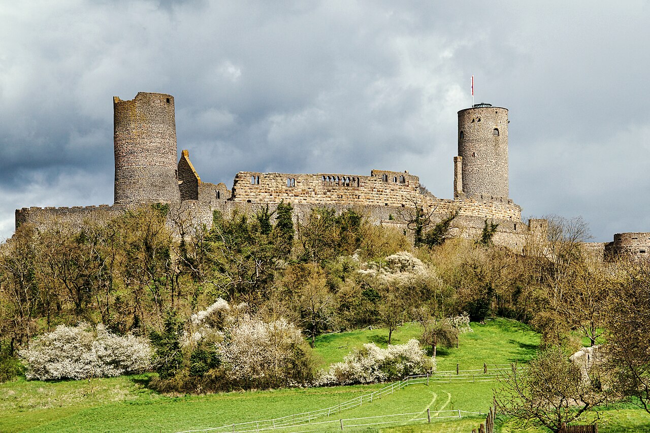
The Münzenberg Castle, known by name since 1162, is the ruin of a hilltop castle on the 239 m high Münzenberg in the Hessian Wetteraukreis. It is one of the most important castle complexes in Germany dating from the High Middle Ages
Summary[edit]
| Description |
English: Münzenberg Castle, known by name since 1162, is the ruins of a hilltop castle on the 239-meter-high Münzenberg south of the town of Münzenberg in the Wetterau district in Hesse. It is one of the most important castle complexes in Germany dating from the High Middle Ages. The castle has not been maintained since around 1600. When the Falkenstein family died out in 1418, ownership of the castle became even more fragmented, so that it could no longer fulfill its strategic purpose of securing control. It is significant that the Counts of Solms, as successors to the Falkenstein family, no longer settled in the castle, but south of it. There the new forms of representation (residential castle) and economy (manor) could be better realized.
Deutsch: Die seit 1162 namentlich bekannte Burg Münzenberg ist die Ruine einer Höhenburg auf dem 239 hohen Münzenberg südlich des Ortes Münzenberg im hessischen Wetteraukreis. Sie ist eine der bedeutendsten aus dem Hochmittelalter stammenden Burganlagen Deutschlands. Seit der Zeit um 1600 wurde die Burg nicht mehr unterhalten. Mit dem Aussterben der Falkensteiner im Jahre 1418 splitterten sich die Besitzanteile an der Burg weiter auf, so dass sie ihren strategischen Zweck der Herrschaftssicherung nicht mehr erfüllen konnte. Bezeichnend ist, dass die Grafen von Solms als Besitznachfolger der Falkensteiner nicht mehr in der Burg siedelten, sondern südlich von ihr. Dort ließen sich die neuen Formen der Repräsentation (Wohnschloß) und der Ökonomie (Gutshof) besser verwirklichen.
|
||
| Date | |||
| Source | Own work | ||
| Author | Xjvolker |
| Camera location | | View this and other nearby images on: OpenStreetMap |
|---|
Licensing[edit]
I, the copyright holder of this work, hereby publish it under the following license:
This file is licensed under the Creative Commons Attribution-Share Alike 4.0 International license.
- You are free:
- to share – to copy, distribute and transmit the work
- to remix – to adapt the work
- Under the following conditions:
- attribution – You must give appropriate credit, provide a link to the license, and indicate if changes were made. You may do so in any reasonable manner, but not in any way that suggests the licensor endorses you or your use.
- share alike – If you remix, transform, or build upon the material, you must distribute your contributions under the same or compatible license as the original.

|
This image was uploaded as part of Wiki Loves Monuments 2023.
|
File history
Click on a date/time to view the file as it appeared at that time.
| Date/Time | Thumbnail | Dimensions | User | Comment | |
|---|---|---|---|---|---|
| current | 19:38, 7 September 2023 | | 5,853 × 3,902 (17.75 MB) | Xjvolker (talk | contribs) | Uploaded own work with UploadWizard |
You cannot overwrite this file.
File usage on Commons
The following page uses this file:
File usage on other wikis
The following other wikis use this file:
- Usage on de.wikipedia.org