File:Mönarpa mossar i Vilske Vartofta och Frökinds härader.jpg
Jump to navigation
Jump to search
Size of this preview: 523 × 599 pixels. Other resolutions: 209 × 240 pixels | 419 × 480 pixels | 870 × 997 pixels.
Original file (870 × 997 pixels, file size: 550 KB, MIME type: image/jpeg)
Captions
Captions
Add a one-line explanation of what this file represents
Summary
[edit]
| Description |
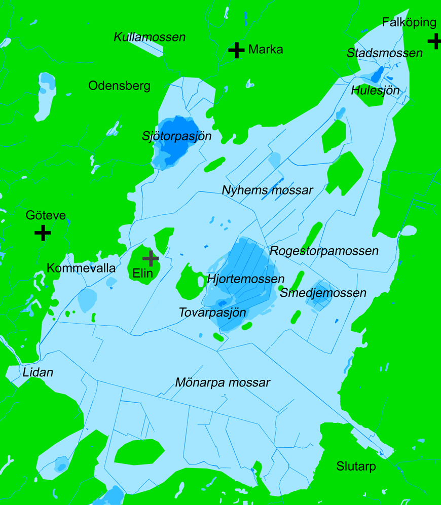
English: Map over the bog complex Mönarpa mossar (Mönarp's bogs) in the municipality of Falköping, Västergötland (Westrogothia), Sweden. Scale 1:40,000. Land is green. Lakes and watercourses are blue. Bogs are lighter blue. Drained peat soil is lightest blue.
Svenska: Karta över mosskomplexet Mönarpa mossar i Falköpings kommun, Västergötland, Sverige. Skala 1:40000. Fastlandet är grönt. Nuvarande sjöar och vattendrag är blå. Mossar är ljusare blå. Utdikad mossmark är ljusast blå. Namngivna i kursiv stil är ån Lidan, sjöarna Sjötorpasjön, Tovarpasjön och Hulesjön, samt mossarna Mönarpa mossar, Hjortemossen, Smedjemossen, Rogestorpamossen, Nyhems mossar och Stadsmossen. För orienteringen är Göteve kyrka, Marka kyrka och Falköpings S:t Olofs kyrka markerade med svarta kors. Elins ödekyrka är markerad med ett grått kors. Namnen på samhällena Odensberg och Slutarp är också utsatta för att underlätta orientering. |
| Date | |
| Source | Own work |
| Author | Gunnar Creutz (Achird) |
| Other versions |
  |
Licensing
[edit]
| I, the copyright holder of this work, release this work into the public domain. This applies worldwide. In some countries this may not be legally possible; if so: I grant anyone the right to use this work for any purpose, without any conditions, unless such conditions are required by law. |
File history
Click on a date/time to view the file as it appeared at that time.
| Date/Time | Thumbnail | Dimensions | User | Comment | |
|---|---|---|---|---|---|
| current | 17:15, 27 June 2010 | | 870 × 997 (550 KB) | Achird (talk | contribs) | {{Information |Description={{en|1=Map over the bog complex Mönarpa mossar (Mönarp's bogs) in the municipality of Falköping, Västergötland (Westrogothia), Sweden. Scale 1:40,000. Land is green. Lakes and watercourses are blue. Bogs are lighter blue. D |
You cannot overwrite this file.
File usage on Commons
The following 2 pages use this file: