File:Lut Desert (MODIS 2024-04-06).jpg

Original file (1,248 × 885 pixels, file size: 139 KB, MIME type: image/jpeg)
Captions
Captions
Summary[edit]
.jpg&action=edit§ion=1)
| Description |
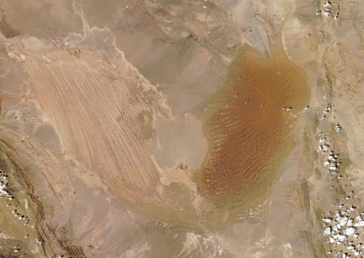
English: On April 5, 2024, the Moderate Resolution Imaging Spectroradiometer (MODIS) on NASA’s Aqua satellite acquired a stunning true-color image of the Lut Desert (Dasht-e Lut) in southeastern Iran.
In the Persian language, “Lut” refers to bare land without water and devoid of vegetation, and the hyper-arid region meets that definition. It is a land of extremes, including capturing the title of “the hottest place on Earth”, which it technically shares with the Sonoran Desert. While Death Valley has the highest air temperature, land surface temperatures as measured by MODIS data showed that in 2018, Lut hit an all-time high surface temperature of 80.8°C (177.4°F). The Sonoran Desert also hit this mark in 2019. As if one superlative wasn’t enough, the Lut Desert also contains some of the world’s best examples of aeolian yardangs landforms, according to the UNESCO World Heritage Committee. Yardangs are defined as, “bedrock features carved and streamlined by sandblasting”. In the Lut Desert, sandblasting occurs when tiny quartz sand grains are carried by long-lasting and tremendously intense winds, most often in the spring and summer. From space, the field of yardangs can be seen as a large patch of linear lines in the western desert. The lines are oriented parallel to prevailing wind. The rusty-colored area in the east is filled with sand and contains some of the tallest sand dunes on Earth, some of which reach a height of 475 meters (1,550 feet). The dunes take on various forms. Many are linear, but some look more like a crescent, or a star, or are funnel shaped. |
||
| Date | Taken on 5 April 2024 | ||
| Source |
|
||
| Author | MODIS Land Rapid Response Team, NASA GSFC |
| This media is a product of the Aqua mission Credit and attribution belongs to the mission team, if not already specified in the "author" row |
Licensing[edit]
.jpg&action=edit§ion=2)
| This file is in the public domain in the United States because it was solely created by NASA. NASA copyright policy states that "NASA material is not protected by copyright unless noted". (See Template:PD-USGov, NASA copyright policy page or JPL Image Use Policy.) | ||
 |
Warnings:
|
File history
Click on a date/time to view the file as it appeared at that time.
| Date/Time | Thumbnail | Dimensions | User | Comment | |
|---|---|---|---|---|---|
| current | 05:05, 6 April 2024 | | 1,248 × 885 (139 KB) | OptimusPrimeBot (talk | contribs) | #Spacemedia - Upload of http://modis.gsfc.nasa.gov/gallery/images/image04062024_250m.jpg via Commons:Spacemedia |
You cannot overwrite this file.
File usage on Commons
There are no pages that use this file.
.jpg&oldid=866210797)