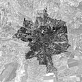
File:Lublin 1944 aerial image.jpg

Original file (19,687 × 19,687 pixels, file size: 86.77 MB, MIME type: image/jpeg)
Captions
Captions
Summary[edit]
| Warning | The original file is very high-resolution. It might not load properly or could cause your browser to freeze when opened at full size. |
|---|
| Title |
English: 'Lublin 1944 aerial image'. |
| DescriptionLublin 1944 aerial image.jpg |
English: Lublin in 1944. Mosaic of aerial images taken by Luftwaffe from May to October 1944. Original images were obtained from National Archives and Records Administration, College Park, MD (https://catalog.archives.gov/id/306065). Scale 1:10,000, size in print 1m x 1m, resolution 500 dpi, grayscale. Area outside the 1931-1947 administrative boundary of the city is masked. |
| Date | |
| Source | Own work |
| Creator | |
| Geotemporal data | |
| Date depicted | |
| Map location | Lublin, Poland |
| Map type | aerial image |
| Spatial reference system | EPSG:2180. |
| Scale | 1:10000 |
| Georeferencing | Georeference the map in Wikimaps Warper If inappropriate please set warp_status = skip to hide. |
| Archival data | |
| Dimensions |
height: 100 cm (39.3 in); width: 100 cm (39.3 in) dimensions QS:P2048,100.0U174728 dimensions QS:P2049,100.0U174728 |
| artwork-references | Lublin Ortophotomap 1944. |
| Scan resolution | 500 dpi |
| Camera location | 51° 14′ 42″ N, 22° 34′ 12″ E | View this and other nearby images on: OpenStreetMap |
|---|
I hereby share my work under Creative Commons license CC BY-SA 4.0 (Attribution - ShareAlike). The project was developed at Maria Curie-Sklodowska University in Lublin under the Polish National Science Centre grant programme - Miniatura 4.0. ref. no. 2020/04/X/HS4/00382. More information at https://ortolub.umcs.pl
Licensing[edit]
- You are free:
- to share – to copy, distribute and transmit the work
- to remix – to adapt the work
- Under the following conditions:
- attribution – You must give appropriate credit, provide a link to the license, and indicate if changes were made. You may do so in any reasonable manner, but not in any way that suggests the licensor endorses you or your use.
- share alike – If you remix, transform, or build upon the material, you must distribute your contributions under the same or compatible license as the original.
File history
Click on a date/time to view the file as it appeared at that time.
| Date/Time | Thumbnail | Dimensions | User | Comment | |
|---|---|---|---|---|---|
| current | 07:22, 19 October 2022 |  | 19,687 × 19,687 (86.77 MB) | Jakub Kuna (talk | contribs) | Uploaded 500dpi 24-bit (RGB) file, hope this would solve Wikimaps Warper display issues. |
| 13:11, 25 March 2022 |  | 19,687 × 19,687 (51.22 MB) | Jakub Kuna (talk | contribs) | uploaded optimised JPEG file (Irfan View, 8-bit) for Wikimaps Warper | |
| 14:10, 23 September 2021 |  | 19,687 × 19,687 (76.15 MB) | Jakub Kuna (talk | contribs) | uploaded higher resolution image (500 dpi) | |
| 13:31, 23 September 2021 |  | 11,812 × 11,812 (28.45 MB) | Jakub Kuna (talk | contribs) | Uploaded own work with UploadWizard |
You cannot overwrite this file.
File usage on Commons
The following 3 pages use this file:
Metadata
This file contains additional information such as Exif metadata which may have been added by the digital camera, scanner, or software program used to create or digitize it. If the file has been modified from its original state, some details such as the timestamp may not fully reflect those of the original file. The timestamp is only as accurate as the clock in the camera, and it may be completely wrong.
| Image title | Lublin 1944 |
|---|---|
| Author | J. Kuna |
| Copyright holder | CC BY-SA 4.0 |
| Width | 38,397 px |
| Height | 44,310 px |
| Bits per component | 8 |
| Compression scheme | LZW |
| Pixel composition | Black and white (Black is 0) |
| Orientation | Normal |
| Number of components | 1 |
| Horizontal resolution | 500 dpi |
| Vertical resolution | 500 dpi |
| Data arrangement | chunky format |
| Software used | Adobe Photoshop CS6 (Windows) |
| File change date and time | 09:08, 19 October 2022 |
| Color space | sRGB |
| Date and time of digitizing | 11:00, 19 October 2022 |
| Date metadata was last modified | 11:08, 19 October 2022 |
| Unique ID of original document | xmp.did:FD57B7B17B4FED11AA2F8162A20C8FBB |
| IIM version | 32,768 |