File:Location results from WMUK BL georeferencing pilot phase.jpg
Location_results_from_WMUK_BL_georeferencing_pilot_phase.jpg (546 × 402 pixels, file size: 90 KB, MIME type: image/jpeg)
Captions
Captions
 This media file has been nominated for deletion since 16 March 2024. To discuss it, please visit the nomination page.
Do not remove this tag until the deletion nomination is closed. Reason for the nomination: Googlemaps CopyVio
| |||
Show further instructions
If this template was added because you clicked "Mark for deletion" in the left menu (right when using Vector 2022 skin), please make sure that all necessary pages have been created. If they haven't been created after a few minutes, or if you added this template manually, you should complete these steps:
{{subst:delete2|image=File:Location results from WMUK BL georeferencing pilot phase.jpg|reason=Googlemaps CopyVio}} ~~~~
For mass deletions: If you want to nominate several related images, please make a mass request by manually adding Note: This template is for requests that may require discussion in order to be deleted. For speedy deletions, you can use
| |||
Summary[edit]
| DescriptionLocation results from WMUK BL georeferencing pilot phase.jpg |
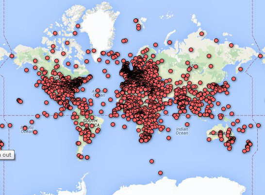
English: Pin map showing the centres identified via georeferencing for the 3000 map images in the pilot phase of the BL/WMUK georeferencing project |
| Date | |
| Source |
This is a Google pin map automatically generated from the BL/Klokan georeferencer program, showing the centres identified via georeferencing for the 3000 map images in the pilot phase of the BL/WMUK georeferencing project. I submit that the image is copyright ineligible under U.S. law, as lacking sufficient original creative expression, since the outline of the world at this resolution and its presentation on a Mercator projection is well known and entirely conventional; while the placement of the pins represents an equally conventional representation of an assembly of data from crowdsourcing that, if it is subject to copyright at all, is released by the British Library on CC0 terms. |
| Author | Jheald |
Licensing[edit]
| Public domainPublic domainfalsefalse |
| This work is ineligible for copyright and therefore in the public domain because it consists entirely of information that is common property and contains no original authorship. |
File history
Click on a date/time to view the file as it appeared at that time.
| Date/Time | Thumbnail | Dimensions | User | Comment | |
|---|---|---|---|---|---|
| current | 00:38, 27 April 2015 |  | 546 × 402 (90 KB) | Jheald (talk | contribs) | User created page with UploadWizard |
You cannot overwrite this file.
File usage on Commons
The following page uses this file:
Metadata
This file contains additional information such as Exif metadata which may have been added by the digital camera, scanner, or software program used to create or digitize it. If the file has been modified from its original state, some details such as the timestamp may not fully reflect those of the original file. The timestamp is only as accurate as the clock in the camera, and it may be completely wrong.
| JPEG file comment | Created with GIMP |
|---|

