File:LocationSouthAfrica-1990.png
Jump to navigation
Jump to search
No higher resolution available.
LocationSouthAfrica-1990.png (250 × 115 pixels, file size: 5 KB, MIME type: image/png)
Captions
Captions
Add a one-line explanation of what this file represents

|
File:South Africa in its region (1990).svg is a vector version of this file. It should be used in place of this PNG file when not inferior.
File:LocationSouthAfrica-1990.png → File:South Africa in its region (1990).svg
For more information, see Help:SVG. |
.svg) |
Summary
[edit]
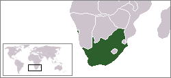
A locator map of South Africa showing en:Walvis Bay. This locator map is intended for South African articles taking place before the transfer of Walvis Bay to Namibia in 1994. The orginal map is by Vardion. Since that map is PD, this one is well.
Licensing
[edit]
| This work has been released into the public domain by its author, Hoshie. This applies worldwide. In some countries this may not be legally possible; if so: |
File history
Click on a date/time to view the file as it appeared at that time.
| Date/Time | Thumbnail | Dimensions | User | Comment | |
|---|---|---|---|---|---|
| current | 07:26, 17 December 2009 | | 250 × 115 (5 KB) | Hoshie (talk | contribs) | Reverted to version as of 03:34, 16 August 2006 rv, Nambia itself wasn't a part of S. Africa |
| 18:37, 2 December 2008 |  | 250 × 115 (5 KB) | ChrisDHDR (talk | contribs) | South Africa included Namibia at the time | |
| 03:34, 16 August 2006 |  | 250 × 115 (5 KB) | Hoshie (talk | contribs) | == Summary == A locator map of South Africa showing en:Walvis Bay. This locator map is intended for South African articles taking place before the transfer of Walvis Bay to Nambia in 1994. The orginal map is by [[Us |
You cannot overwrite this file.
File usage on Commons
The following page uses this file: