File:Light-Toned Material among Dunes in Lyot Crater.jpg
Jump to navigation
Jump to search

Size of this preview: 800 × 317 pixels. Other resolutions: 320 × 127 pixels | 840 × 333 pixels.
Original file (840 × 333 pixels, file size: 259 KB, MIME type: image/jpeg)
Captions
Captions
Add a one-line explanation of what this file represents
| Description |
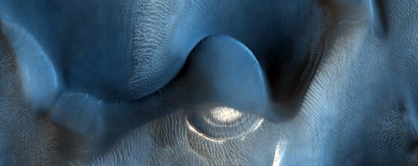
English: Barchan dunes on Mars, in Lyot crater, as seen by HiRISE on the Mars Reconnaissance Orbiter. From Wikipedia's article on Lyot crater: Lyot Crater is the deepest point in Mars's northern hemisphere. The image below of Lyot Crater Dunes shows a variety of interesting forms: dark dunes, light-toned deposits, and dust devil tracks. Light-toned deposits are widely believed to contain minerals formed in water. Research, published in June 2009, described evidence for liquid water in Lyot crater in the past.
Ελληνικά: Μηνοειδείς θίνες στην επιφάνεια του Άρη, στον κρατήρα Λιό (Lyot). Το ανοιχτόχρωμο υλικό πιστεύεται ότι αποτελείται από πετρώματα που σχηματίστηκαν με την παρουσία νερού. Εικόνα από το τηλεσκόπιο HiRISE, στη διαστημοσυσκευή Mars Reconnaissance Orbiter της NASA. |
|||||
| Date | ||||||
| Source | HiRISE webpage, file | |||||
| Author | NASA/JPL/University of Arizona | |||||
| Permission (Reusing this file) |
|
|||||
| Other versions |
 |

| Location on Mars | View this and other nearby images on: Google Maps |
|---|
File history
Click on a date/time to view the file as it appeared at that time.
| Date/Time | Thumbnail | Dimensions | User | Comment | |
|---|---|---|---|---|---|
| current | 14:53, 17 September 2011 | 840 × 333 (259 KB) | Badseed (talk | contribs) | {{Information |Description={{en|Barchan dunes on Mars, in Lyot crater, as seen by HiRISE on the Mars Reconnaissance Orbiter. From Wikipedia's article on Lyot crater: Lyot Crater is the deepest point in Mars's |
You cannot overwrite this file.
File usage on Commons
The following page uses this file: