File:Level III and IV Ecoregions of EPA Region 4.png
Jump to navigation
Jump to search

Size of this preview: 460 × 599 pixels. Other resolutions: 184 × 240 pixels | 368 × 480 pixels | 589 × 768 pixels | 786 × 1,024 pixels | 1,572 × 2,048 pixels | 6,600 × 8,600 pixels.
Original file (6,600 × 8,600 pixels, file size: 3.41 MB, MIME type: image/png)
Captions
Captions
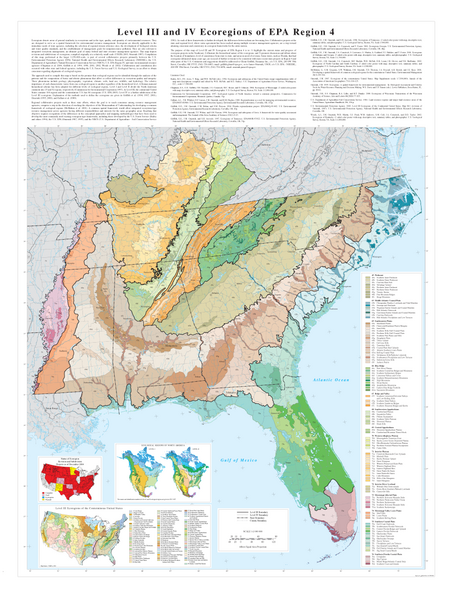
Map of Level III and IV Ecoregions of EPA Region 4
Summary[edit]
| Description |
English: Map of Level III and IV Ecoregions of EPA Region 4. Map is produced by the US EPA. |
| Date | |
| Source | https://www.epa.gov/eco-research/ecoregion-download-files-region#pane-04 |
| Author | Griffith, Glenn, and Omernik, James for the US EPA |
Licensing[edit]
This image (or other media) is a work of an Environmental Protection Agency employee, taken or made as part of that person's official duties. As works of the U.S. federal government, all EPA images are in the public domain.
|
||
File history
Click on a date/time to view the file as it appeared at that time.
| Date/Time | Thumbnail | Dimensions | User | Comment | |
|---|---|---|---|---|---|
| current | 18:55, 10 March 2024 | | 6,600 × 8,600 (3.41 MB) | MiseDominic (talk | contribs) | Uploaded a work by Griffith, Glenn, and Omernik, James for the US EPA from https://www.epa.gov/eco-research/ecoregion-download-files-region#pane-04 with UploadWizard |
You cannot overwrite this file.
File usage on Commons
There are no pages that use this file.